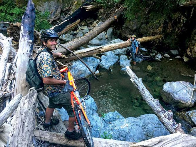
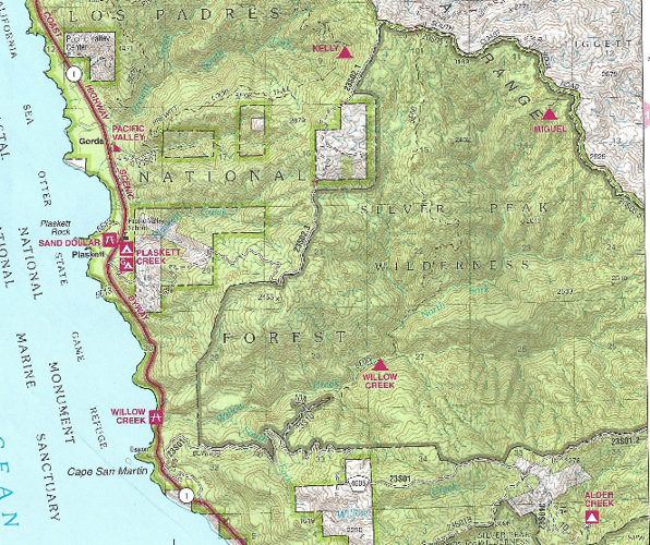

Author's note: The Weekly has confirmed this route, starting from Kinder Mine Road and to the end of Willow Creek Trail, is part of a 2002 addition to the Silver Peak Wilderness, and as such, is illegal to ride bikes in. That was not indicated on our map, or anything we could find online, nor was it signed. The Weekly posted a map of the region's wilderness, viewable by clicking on the right arrow of the above photo.
--
It’s supposed to be a shortcut.
At least that’s how Carmel Highlands resident Jan Doelman, on a night in late June under a tapestry of stars, describes the plan.
We’re sitting on the deck of a house he co-owns in Big Sur, about three miles north of Gorda. Also in the group are Santa Barbara resident and fellow co-owner David Erlach, and Pacific Grove resident Jonathan Roberts.
It seems simple: From the crest of Nacimiento-Fergusson Road, we ride mountain bikes south over the small peaks and valleys of the unpaved South Coast Ridge Road, then turn coastward, down Kinder Mine Road – also unpaved – to check out an old gold mine.
From there, we traverse two miles of the Willow Creek Trail. Doelman, a Los Padres National Forest veteran and self-described “connoisseur of bad trails,” says that stretch “might get spicy.” Then it’s onto Willow Creek Road, which will reconnect us with Highway 1.
Making the trail connection, as opposed to sticking to dirt roads, will not only give us the opportunity to explore the Kinder Mine, but it will shave off several miles of riding.
Around 11am the next day, at the saddle of Nacimiento-Fergusson, we unload our bikes from Doelman’s pickup. “This ride is going to separate the wheat from the chaff,” Erlach says.
The Los Padres has a reputation for overgrown, poorly maintained trails, and after the wettest winter in years – which boosted plant growth – that reputation soon proves accurate.
In the beginning, everything goes as planned: We suffer through the peaks, valleys and dust, sweating in the heat.
Not long after a short side-trip to Prewitt Ridge, which affords sweeping views of the coastline, we descend past a metal gate that blocks vehicle access to Kinder Mine Road.
The vegetation rips at our arms, drawing blood. We lower our heads and buckle down…
The road is heavily overgrown with chaparral, and it appears no motorized vehicles have driven it for years. As we make our dicey descent, doing our best to steer clear of ruts and large rocks, the vegetation rips at our arms, drawing blood. We lower our heads and buckle down, using our bike helmets to prevent branches from whipping our faces.
A few miles down, Roberts gets a flat. After he patches up his tube and we get ready to continue, Doelman realizes he too has a flat. It’s past 2pm, with four miles of dirt road and two miles of trail ahead of us. It’s six hours until sunset.
Minutes later, Roberts gets another flat. He has only one patch left, and the tube is punctured in two places.
He cuts the patch in two, but after applying it, it becomes clear the patch isn’t holding when his tire deflates. We are five-plus miles from the coast, and he’s going to have to walk his bike out.
But we are close to the Kinder Mine, and Roberts walks his bike downhill and meets us there just minutes after we arrive. There, an abandoned, two-story redwood-shingle house sits in a remote meadow. Old, handsome redwoods stand behind it, and budding grapevines climb on trellises next to it.
A decayed mining wheel in a meadow is the only evidence we see of the gold operation that started in the early 1900s, where no paydirt was ever struck.
After poking around, we think we find the Willow Creek Trail and set off on foot, pushing our bikes. About 50 yards into the forest, the trail disappears.
The day is growing shorter, and there is little time for debate. We act quickly and pass our bikes downhill – bracing ourselves with the roots of a tree – and carry them down a ravine, toward Willow Creek, about 100 yards off.
When Erlach takes a spill by the edge of the creek, falling facedown into a bush, he doesn’t realize his iPhone is sliding out of his pocket.
The going in the creek is slow, and becomes increasingly difficult. Numerous styles of carrying a bike are employed – a seat on the shoulder, or the bike resting on one’s back. As the water deepens, eventually reaching chest-deep, Erlach realizes he lost his phone. He goes back to search for it where he fell, and finds it. The canyon is darkening.
Snags in the creek begin to appear at almost every corner, with fallen trees and large boulders blocking the way. Climbing over and down them – while carrying a mountain bike – requires slow, careful steps to keep from falling.
After we cover less than a half-mile in 90 minutes, we check the time. It’s 5pm, with more than four miles to go.
At a tributary, Doelman searches for the trail and finds it just uphill. It’s narrow, overgrown and has a steep drop-off. Bad as it is, it’s better than the creek.
When we reach Willow Creek Road, the sun is almost setting, and Doelman and I make a speedy descent down the dirt road toward Treebones for a beer. Erlach has already pushed ahead to retrieve his truck, while Roberts is behind us, walking his bike.
Just as Doelman and I get a cold Kirin in hand, the sun hits the ocean.


(3) comments
Thanks to David for making the important correction that precedes this article. The story is an exciting one and I totally understand the appeal. However, the fact that a detailed account of a wilderness incursion passed muster in the newsroom, withstood fact-checking and made it into print speaks to widespread misconceptions about appropriate use of our public lands.
I’m not here to chastise anyone, but hope that we can turn this into a teachable moment, set aside our differences and join forces to support the conservation of what little wild country remains here on the central coast. Heaven knows there are many who’d love to pit us against one another and sell off our collective birthright while we tussle in the ensuing smokescreen (Utah Senators Mike Lee and Orrin Hatch’s “Human-Powered Travel in Wilderness Act” come to mind).
The bad news is that maps and signs have their limits. Our non-profit organization works closely with commercial mapping operations that cover the Big Sur bckcountry. In our opinion, they’ve generally done a good job keeping trails, roads and wilderness boundaries current. While maps printed prior to 2002 obviously would not reflect the Silver Peak Wilderness addition referenced in this article, planning an adventure into terra incognita using 15+ year-old maps is definitely not advisable. Nor is the expectation that signage will clearly articulate land-use regulations. The first Leave No Trace principle, “Plan Ahead and Prepare” admonishes one to “know the regulations and special concerns for the area you’ll visit.” In other words, know before you go! With the ever-increasing use of Big Sur’s precious public lands comes a shared responsibility to know the rules, leave no trace of our adventures, and to educate friends and fellow visitors to do the same.
The good news is that Monterey County is blessed with abundant public lands. County Parks, Monterey Peninsula Regional Park District lands, California State Parks and Fort Ord National Monument offer a vast array of recreational opportunities, including loads of legal mountain bike trails. Bureau of Land Management units on the interior tend toward multiple use, including resource extraction. Pinnacles National Park, although focused on conservation, still features attractive recreation options for hikers and rock climbers alike. But let’s focus on the Los Padres National Forest Monterey Ranger District, where this story takes place.
All but a few of the Monterey Ranger District’s 313,000-odd acres are within Monterey County, and of this total, more than 270,000 acres have been federally designated as the Ventana and Silver Peak Wilderness. As defined in the Wilderness Act of 1964, wilderness is a special designation created to protect a select few places “where the earth and its community of life are untrammeled by man”. Wilderness offers “outstanding opportunities for solitude or a primitive and unconfined type of recreation”. Wilderness strictly prohibits “motor vehicles, motorized equipment… mechanical transport.” It is a place where we have agreed to practice restraint and leave convenience behind so as to connect with nature on its own terms.
I’m an avid hiker and mountain biker myself, and in such a highly urbanized landscape, consider it a genuine honor to be able lock my bike at a wilderness trailhead and enter slowly and quietly, on foot. It’s also the law. As public landowners, it’s up to all of us to care for our wide open spaces, know what’s appropriate where, and exercise restraint when it is warranted. Let’s keep it wild!
Mike Splain, Ventana Wilderness Alliance
Bicycles should not be allowed in any natural area. They are inanimate objects and have no rights. There is also no right to mountain bike. That was settled in federal court in 1996: http://mjvande.info/mtb10.htm . It's dishonest of mountain bikers to say that they don't have access to trails closed to bikes. They have EXACTLY the same access as everyone else -- ON FOOT! Why isn't that good enough for mountain bikers? They are all capable of walking....
A favorite myth of mountain bikers is that mountain biking is no more harmful to wildlife, people, and the environment than hiking, and that science supports that view. Of course, it's not true. To settle the matter once and for all, I read all of the research they cited, and wrote a review of the research on mountain biking impacts (see http://mjvande.info/scb7.htm ). I found that of the seven studies they cited, (1) all were written by mountain bikers, and (2) in every case, the authors misinterpreted their own data, in order to come to the conclusion that they favored. They also studiously avoided mentioning another scientific study (Wisdom et al) which did not favor mountain biking, and came to the opposite conclusions.
Those were all experimental studies. Two other studies (by White et al and by Jeff Marion) used a survey design, which is inherently incapable of answering that question (comparing hiking with mountain biking). I only mention them because mountain bikers often cite them, but scientifically, they are worthless.
Mountain biking accelerates erosion, creates V-shaped ruts, kills small animals and plants on and next to the trail, drives wildlife and other trail users out of the area, and, worst of all, teaches kids that the rough treatment of nature is okay (it's NOT!). What's good about THAT?
To see exactly what harm mountain biking does to the land, watch this 5-minute video: http://vimeo.com/48784297.
In addition to all of this, it is extremely dangerous: http://mjvande.info/mtb_dangerous.htm .
For more information: http://mjvande.info/mtbfaq.htm .
The common thread among those who want more recreation in our parks is total ignorance about and disinterest in the wildlife whose homes these parks are. Yes, if humans are the only beings that matter, it is simply a conflict among humans (but even then, allowing bikes on trails harms the MAJORITY of park users -- hikers and equestrians -- who can no longer safely and peacefully enjoy their parks).
The parks aren't gymnasiums or racetracks or even human playgrounds. They are WILDLIFE HABITAT, which is precisely why they are attractive to humans. Activities such as mountain biking, that destroy habitat, violate the charter of the parks.
Even kayaking and rafting, which give humans access to the entirety of a water body, prevent the wildlife that live there from making full use of their habitat, and should not be allowed. Of course those who think that only humans matter won't understand what I am talking about -- an indication of the sad state of our culture and educational system.
Now watch the mountain bikers lie and attack me for telling the truth about their selfish, destructive sport!
There is a problem with this little "adventure." It is illegal. Check your USFS regs. "ountain biking is a growing sport. Riding is permitted only on designated forest roads and trails. Riding is not permitted inside designated Wilderness areas and some "Front Country" trails. " From the gate, down to the creek all the way down to the highway is Silver Peak Wilderness area, a designated wilderness area. Please don't be advising others to take this road. And further, the Kinder Mine is owned by a friend of mine, and is NOT abandoned. He hikes in.
Welcome to the discussion.
Log In
Keep it Clean. Please avoid obscene, vulgar, lewd, racist or sexually-oriented language.
PLEASE TURN OFF YOUR CAPS LOCK.
Don't Threaten. Threats of harming another person will not be tolerated.
Be Truthful. Don't knowingly lie about anyone or anything.
Be Nice. No racism, sexism or any sort of -ism that is degrading to another person.
Be Proactive. Use the 'Report' link on each comment to let us know of abusive posts.
Share with Us. We'd love to hear eyewitness accounts, the history behind an article.