
The Pajaro River and its tributaries are, for the most part, hidden.
Despite traversing a few dozen miles throughout Monterey and Santa Cruz counties, the general public typically notices it when they cross a bridge here and there – or when it floods, as it is all too prone to do. The vegetation that grows in and around the river is so thick that it conceals the trickle of water from within, left mostly undisturbed since the levee system was built in 1949. And in areas such as Corralitos Creek in Watsonville, the tributary was essentially shaped by farmers over the decades.

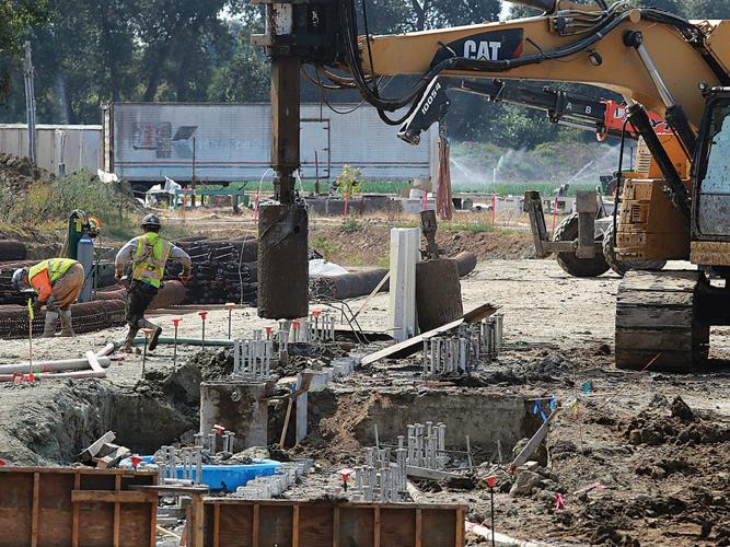
Work on the Pajaro River Flood Risk Management Project is underway along Corralitos Creek in Watsonville. It’s the first phase of a multi-year project to add new levees and rebuild the system constructed in 1949.
When dignitaries gathered along Corralitos Creek in October 2024, the area was unrecognizable. The land around the creek had been cleared, exposing a section of the waterway that for years has been hidden in plain sight. Beyond the wildlife – and the unhoused people – who live in the creekbed, this was the first time many had seen it with their own eyes.
The life that surrounds the river is in a constant state of balance. Vegetation provides important habitat for birds, fish and other wildlife that depend on the river for survival. Too much of it, however, can block the river’s flow, and in times of a heavy downpour, that water has to go somewhere – oftentimes breaching the channel and flooding neighborhoods.
That October day marked a milestone for the Pajaro River Flood Risk Management Project. After decades of floods, damage and lives uprooted, the project – to at last provide a more secure levee – broke ground.
Nearly two years later, work to construct a levee along Corralitos Creek has hit a high gear, clearing more land in the area than ever before and uncovering this natural feature that surrounds communities of tens of thousands of people.
As the decades-overdue levee project continues, a group of researchers are finding a way to make life better for both the animals that reside in the river and those responsible for the levee’s maintenance.
IN SUMMER 2023, the University of California was awarded more than $80 million in grants to support projects that help communities adapt to climate change.
Five projects at UC Santa Cruz received grants, including $1.9 million to a team led by Earth and Planetary Sciences Professor Andrew Fisher.

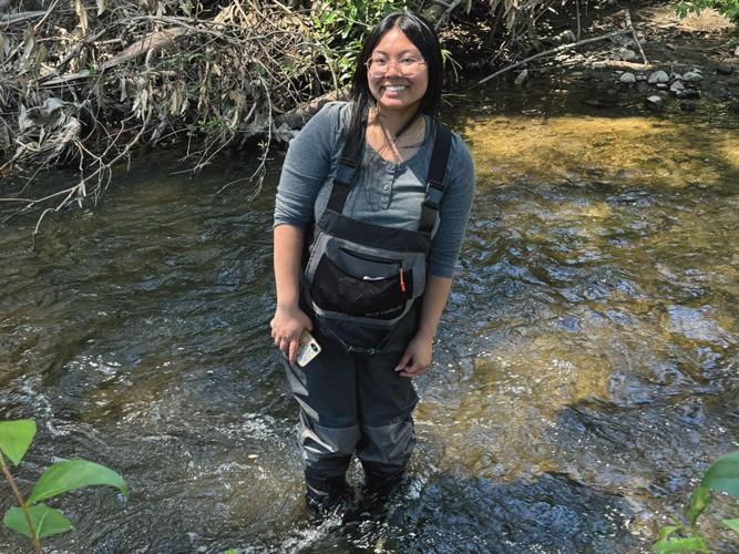
Lauryn Tagashira is among the CSU Monterey Bay students studying biodiversity in the Pajaro River.
Fisher says he has long been interested in how climate change affects the cycle of water, and was thrilled when the grant funds came through. The group of researchers led by Fisher had submitted a proposal for the grant just two months before the Pajaro flood.
“It’s serious funding that lets us do something I’ve been dreaming of for a long time,” he says. As the climate warms, more precipitation is falling as water rather than snow. And as recent years have shown, while the total amount of rainfall for a season has remained relatively constant, the storms are increasing in intensity, Fisher says.
More land covered by pavement and altered by humans in other ways leads to more runoff heading into rivers and streams, stressing systems, he notes. Case in point is the Pajaro River levee, which crumbled in March 2023 and caused floodwaters to tear through Pajaro, forcing hundreds of people to evacuate and causing countless dollars in damage.
When the $599 million funding for the levee project was announced, Fisher organized a group to come up with a plan to gather research on how a levee rebuild project could have further benefits beyond reducing the flood risk.
“I had been discussing with regional folks ideas about things that might be done,” he says. “What else could be done to provide benefit? What could be done to improve water quality? What could be done to improve groundwater recharge?”
With a team in place, including researchers from CSU Monterey Bay, UC Berkeley, UC Davis and the Resource Conservation District of Santa Cruz County, the group got started in summer 2023. What was originally supposed to be a two-year project was extended by another year.
Now, the researchers – a mix of students and faculty – are putting the finishing touches on their study, due to be released for public viewing in the fall.
Much of what they learned backed up what they already knew. Other things were surprising.
Some people flush their goldfish down the toilet. Others, perhaps more humanely, dump them in the Pajaro River…
CSUMB student researchers studying the habitat in the river found the presence of carp – an invasive species that was possibly introduced by someone throwing their goldfish into the water.
They know this thanks to environmental DNA (eDNA), a type of technology that’s similar to how forensic scientists find evidence in a crime scene.
Using a water, soil or air sample, researchers are able to extract small quantities of degraded DNA from such things as scales and fecal matter, which can give them an idea of what species passed through the area.
“It’s often pretty degraded or broken down,” says Liz Alter, an associate professor of biology at CSUMB. “We have to take a lot of precautions to avoid contamination. We often end up with a lot of human DNA, because it’s everywhere.
“We also have to be careful about contamination from sewage pipes, because then you’re introducing DNA from what people ate for lunch.”
Alter’s lab is heading up the eDNA portion of the overall study to capture a snapshot of the biodiversity in the river. Here, students have taken samples from 10 sites along the river and have now nearly wrapped up their data analysis. While the samples can’t pinpoint the exact location of a species – water flows downstream, after all, taking DNA with it – it does show what is in the river, or has been at some point.
“It’s a complex system which we’re trying to figure out,” Alter says. “If we take a sample of water at this spot, does that mean those species were there 10 minutes ago or an hour ago, or a kilometer away? That’s all inferences that we make.”
She adds the study will provide a more complete picture of habitat in the river than any other such research in the past.
“To date, there’s been patchy surveys of biodiversity of the river,” she says. “The surveys that have occurred so far have been traditional surveys, where you’re going out and visually looking for organisms and counting them. That’s time-consuming, and it’s limited both in how much time and space you can cover.”
The researchers found more than 31 species, including steelhead and Sacramento suckers – “species that we are happy to see because they indicate ecological health in the system,” Alter says.
On the flipside, they discovered some non-native, invasive species, including mosquitofish, catfish and bullfrogs. That can be a problem, because bullfrogs, for example, will eat the eggs and larvae of endangered fish and amphibians, including the long-toed salamander. Mosquitofish, while useful for pest control in ponds or lakes, compete for resources with the native fish.
“We’re working hard to protect the habitat of the native species,” Alter says. “To have non-native species in the system that are actively working against them, that’s a problem.”
Finding evidence of these non-native species is important for the study, which can recommend ways the levee project can modify the habitat to be friendly to the natives and to limit the spread of the invasive species.
CSUMB environmental graduate student Subi Nair says the research helps establish a baseline for the current conditions in the river as a way to guide what impacts the levee project will have not only in the channel, but on the surrounding environment.

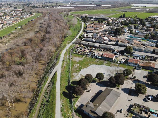
The town of Pajaro is situated next to the river’s levee, making it vulnerable to flooding, as happened most recently in 2023.
“I see this as a larger group effort between a lot of different institutions that are working with this common goal to build a comprehensive report of what these levee setbacks are going to do and the effects down the road,” she says. “Hopefully, we’ll set a precedent for future projects.”
Fisher’s team of student researchers at UCSC is looking at the river’s water quality and recharge. What’s surprising to Fisher is areas of the river that were losing water at a pace quicker than others, yet a couple of months later gained it back.
The researchers suspect it has to do with the geology of the Pajaro Valley, which has an extensive, impervious layer of clay throughout that is a remnant from its history as a vast wetland complex.
“If you have this clay level below the river, that limits where recharge can occur,” Fisher says.
The data from the study can help inform the Army Corps of Engineers, which is managing the project’s construction, how to design and build the levee in a way that benefits water flow and quality. Not only is it designed for the habitat, but also with maintenance in mind, Fisher notes, such as building ramps into the river and staging areas for equipment needed for the upkeep.
“This has been a long-term challenge for the area,” he says. “Keeping these levees functional and keeping these channels clear can be expensive. Are there ways to design this that makes maintenance easier? In the long run, that benefits everybody.”
A FEW TIMES EVERY DECADE, the idea of an El Niño event makes the news, bringing with it the threat of wetter winters and more powerful storms. But such instances are not guaranteed, nor are they likely to happen evenly across the state.

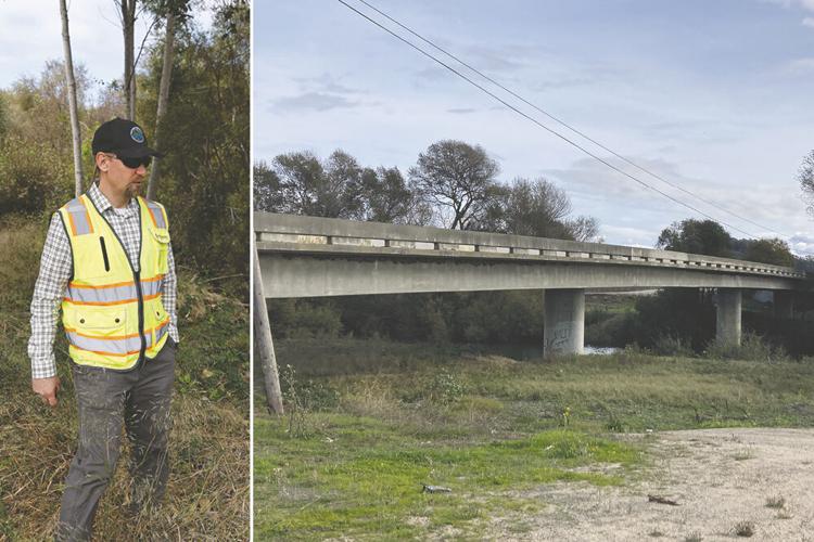
(Left) Mark Strudley, executive director of the Pajaro Regional Flood Management Agency, shows some of the overgrowth in the Monterey County side of the levee. (Right) The Thurwachter Road bridge spans the Pajaro River in Watsonville. Another, smaller breach opened up along the levee near the area in 2023.
Still, local jurisdictions use the late summer and fall to prepare for what may (or may not) come at the end of the year.
The Pajaro Regional Flood Management Agency, which maintains about 26 miles of the Pajaro River system, is gearing up for the winter.
On Aug. 12, PRFMA Executive Director Mark Strudley presented a report to the agency’s board, outlining the winter preparation plan, which while similar to previous years, feels a little more urgent with the possibility of a strong El Niño event.
That includes more than $900,000 for ongoing vegetation clearing and sediment removal. The agency is also investing in a plan to fortify the levees on the Monterey County side, similar to what it did in 2024 when it brought in new soil to reconstruct a portion of the levee and bring it back up to its original height.
PRFMA is also looking at building what is known as “seepage berms,” which are large masses of rocks placed on the sides of the levees to help fortify it and allow water to seep through without taking sediment with it and undermining the levee walls.
“There’s been a lot of media hype about El Niño,” says Strudley, who was previously a hydrologist with the National Weather Service. “It’s tough to tell even with a strong El Niño what that means for us here in the Santa Cruz, Monterey County area. You do get more wet winters in Southern California and the Pacific Northwest. We’re in between that.”
Regardless, he says PRFMA is preparing for whatever may happen.
“The name of the game is preparedness,” Strudley says. “It’s better to be safe than sorry.”
Strudley says he’s been in constant contact with Fisher and the researchers as the results from the study trickle in. While the study is only a recommendation and not binding, Strudley adds it’s been “super helpful to have.”
The research can help inform the design of the levee, he says, as the Army Corps of Engineers relies on studies to show the best way to build the channel to maximize flood protection within the constraints of the space it has to work with. But it can also guide the design in a way that accomplishes that goal while benefiting water quality and wildlife. Those specific recommendations from the researchers will be outlined in the final report.
“It’s showing us things that we otherwise wouldn’t necessarily know,” Strudley says. “It’s helping us understand that maybe we want to put a levee here and not exactly there. Maybe we want to excavate this new floodplain bench to this depth because we think it helps groundwater recharge.”
Construction is underway on what’s known as Reach 6, which is adding levees along a section of Corralitos Creek in Watsonville. Work is expected to continue into 2027, according to Strudley.
The next section, Reach 5, which follows Salsipuedes Creek through Watsonville to the Pajaro bridge, recently passed the 60-percent design milestone, Strudley says, with final design expected sometime in 2027.
Following that are Reaches 4, 3 and 2 in Pajaro (Reach 4 contains the section that broke in 2023). According to Strudley, those phases could have design contracts in place later this year.
State legislators, meanwhile, are close to giving PRFMA more tools to complete levee maintenance projects.
Senate Bill 1055 by State Sen. John Laird, D-Santa Cruz, passed the California Assembly and Senate earlier in August. The PRFMA currently has limited construction procurement methods, such as awarding design and construction projects separately and to the lowest bidder.
The bill opens up four more procurement methods for PRFMA, including what is known as “design-build,” where one contractor is awarded the design and construction project at once.
“SB 1055 gives the Pajaro Regional Flood Management Agency more flexibility to deliver critical levee and flood control improvements faster, helping better protect families, businesses and farmland from future flooding,” Laird said in a statement.
The bill is going through proofreading before it goes to Gov. Gavin Newsom’s desk for his consideration.
Many of the students involved in the research spent this summer putting the final touches on the work they’ve spent the past few years toiling over.
For Nair, that included collecting data from winter 2023 through spring 2024, then spending a year in the lab filtering the water samples and extracting the DNA. It’s been roughly another year of analyzing the data.
Alter says the research project holds a special meaning for many of the students.
“It’s such a relevant issue for anyone who lives in this area,” she says. “We all experienced those intense rainstorms of 2023. The students live in Monterey, San Benito, Santa Cruz counties. They’re very familiar with the terrible flooding and destruction that occurred.
“They see the impacts of climate change firsthand in their communities. This project was really exciting for them in that regard because they had the opportunity to collect data that can make a difference in the long run.”
Both Alter and Nair note that the CSUMB team was just a piece of a bigger project, one they hope will pay dividends in the future.
“We’re a small little puzzle piece in the whole thing,” Alter says. “It’s been amazing to work with such a broad, diverse array of scientists.
(1) comment
Recreation? The Watsonville and Pajaro areas are lacking in recreational opportunities. Introducing children and families to the natural environment hidden in their midst would educate and elevate their relationship with the world hidden right at their doorstep. But not only was this news story devoid of any mention of the opportunity for recreation, but the fact that our elected local officials didn't include recreation is stunning. Imagine families walking and riding bikes along the Pajaro River levee, or the Salsipuedes and Corrolitos creek levee now being constructed. Imagine children from Watsonville High, Pajaro Middle School, and the dozen elementary schools using the river and creek access for introducing them to the natural world. A lost opportunity.
Welcome to the discussion.
Log In
Keep it Clean. Please avoid obscene, vulgar, lewd, racist or sexually-oriented language.
PLEASE TURN OFF YOUR CAPS LOCK.
Don't Threaten. Threats of harming another person will not be tolerated.
Be Truthful. Don't knowingly lie about anyone or anything.
Be Nice. No racism, sexism or any sort of -ism that is degrading to another person.
Be Proactive. Use the 'Report' link on each comment to let us know of abusive posts.
Share with Us. We'd love to hear eyewitness accounts, the history behind an article.