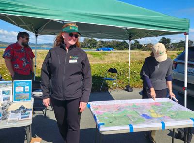

Aric Sleeper here, impressed after I put on a virtual reality headset and took a simulated tour of Elkhorn Slough at the public drop-in session for the Highway 1 Elkhorn Slough Corridor Resiliency Project at the Sea Harvest parking lot in Moss Landing on Wednesday afternoon.
The virtual reality tour provides a bird’s-eye view of the slough and allows the user to see it as it is today and what it will look like after 2 and 5 feet of sea level rise. As you can imagine, portions of Highway 1 and the Union Pacific Railroad line are mostly submerged after 2 feet of sea level rise, and completely underwater after 5.
The resiliency project, intended to prepare for the eventuality of sea level rise, is still in its early stages and the Transportation Agency for Monterey County is seeking public input for the project before moving forward. In addition to drop-in information sessions like the one I attended, a community survey is available (in English or in Spanish), which asks respondents about their relationship to the slough and what they would like to see in the future, such as four lanes on the highway versus two, or bike lanes along the stretch.
During the virtual reality tour, some of the options being considered for the two-lane section of Highway 1 in Moss Landing are presented, which include raising the roadway onto pilings, allowing the seawater to pass through, or adding more earth to the area to raise the land and the roadway. Whatever the project eventually becomes will be up to the public and the many stakeholders, which include TAMC, Caltrans, the Nature Conservancy, the Elkhorn Slough National Estuarine Research Reserve, and the California Coastal Commission.
The project is currently in a pre-environmental review phase known as a planning and environmental linkages study, a relatively new requirement, according to TAMC Planning Director Christina Watson.
“We’re doing this because it’s such a huge undertaking,” Watson says. “It impacts eight miles of the highway, five miles of the railroad, and two different counties and the commuters that go between the two. And it impacts a major natural resource: the slough and the marine sanctuary.”
Watson hopes to receive meaningful feedback from community members to get “the best possible project” before embarking on the environmental review. She mentioned that public outreach is just beginning for those who also want to strap on VR goggles and see a submerged slough.


(0) comments
Welcome to the discussion.
Log In
Keep it Clean. Please avoid obscene, vulgar, lewd, racist or sexually-oriented language.
PLEASE TURN OFF YOUR CAPS LOCK.
Don't Threaten. Threats of harming another person will not be tolerated.
Be Truthful. Don't knowingly lie about anyone or anything.
Be Nice. No racism, sexism or any sort of -ism that is degrading to another person.
Be Proactive. Use the 'Report' link on each comment to let us know of abusive posts.
Share with Us. We'd love to hear eyewitness accounts, the history behind an article.