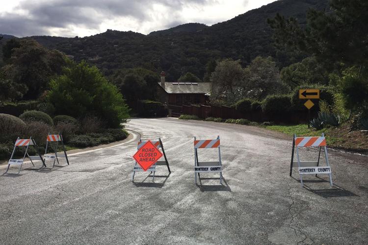
Following years of drought, and a 2015-16 El Niño winter that under-delivered on predicted precipitation, the winter of 2016-17 is making history. Repeated weather events have delivered significant rain and high winds to many areas of Monterey County, resulting in flooding, mudslides, power outages and road closures affecting thousands of people.
Our coverage of the winter weather appears below, with the oldest stories at the bottom.
1
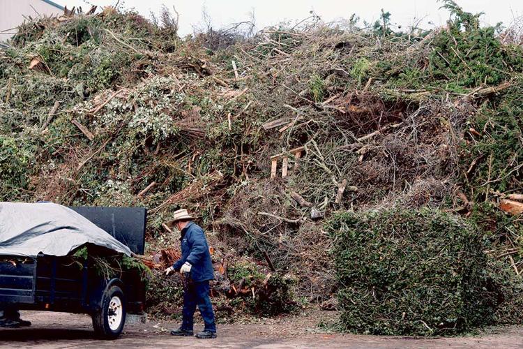
The truckloads of wood and brush just didn’t seem to stop coming March 4 to the Marina landfill. By the end of the day, 150 tons of yard waste had rolled through its gates, the equivalent of 15 garbage trucks. It was the largest single day of green waste disposal in the 65-year history of the dump.
Since a massive storm hit Monterey County Feb. 17-21, the tonnage numbers racked up by the landfill are staggering: 7,580.83 tons of green waste between Feb. 18-March 4, the equivalent weight of more than 2,500 Asian elephants and a 181-percent increase over the same time period last year, according to Jeff Lindenthal, Monterey Regional Waste Management District’s director of communications and sustainability.
“We’re having trouble chipping it fast enough,” Lindenthal says. The district is making plans to bring a new state-of-the-art wood chipper online in the coming weeks to help with disposal. In the meantime, the landfill’s on-site composter, Keith Day Company, is helping grind up surplus debris.
With even more tree and brush debris expected, officials are struggling to meet demand and dispose of it quickly – without causing damage to the environment. A prime example is in Prunedale, where hundreds of eucalyptus, pine and oak trees fell, and where it’s common practice to burn tree debris.
But smoke from burning debris in the many canyons of North County could pose a serious health risk, says Richard Stedman, air pollution control officer for the Monterey Bay Air Resources District. Soon after the storm, Stedman began investigating how to get wood-chipping equipment to Prunedale.
“We don’t have the financial resources to service the whole county,” Stedman says. “We’re trying to target this so we get our biggest bang for the buck.”
He’s taking a budget proposal March 15 to the air district board, seeking approval to pay for the wood-chipping program. He originally planed on asking for $25,000, but now expects he’ll need $100,000 – for Prunedale alone.
And then there’s the issue of what to do with the wood chips. While some residents may want to spread chips directly on their properties, any leftovers will have to go to the already-stressed landfill, which could cost more.
Waste management district officials are talking about whether to accept storm debris as disaster waste, and waive the cost. (The fee for green waste is $30 per ton, compared to $51.75 per ton for solid waste.)
The chips at the landfill are composted and sold as mulch. The composting process, which is designed to sterilize the chips and kill any potential diseases like pine pitch canker or sudden oak death, will neutralize any tannins in eucalyptus wood – highly prevalent in Prunedale – that might damage other plants, Lindenthal says.
The air district is also contemplating how to get rid of debris that flowed down the Salinas River, washing up on surrounding agricultural land. The presence of invasive plants means that debris will have to be burned, rather than chipped and used as mulch; plans are underway to incinerate it onsite.
For Stedman, February’s storm and the colossal debris effort is just a trial run for what’s to come in the future.
“With climate change, we expect to have more of these storms,” he says. “This will probably be the mainstay of the future.”
2
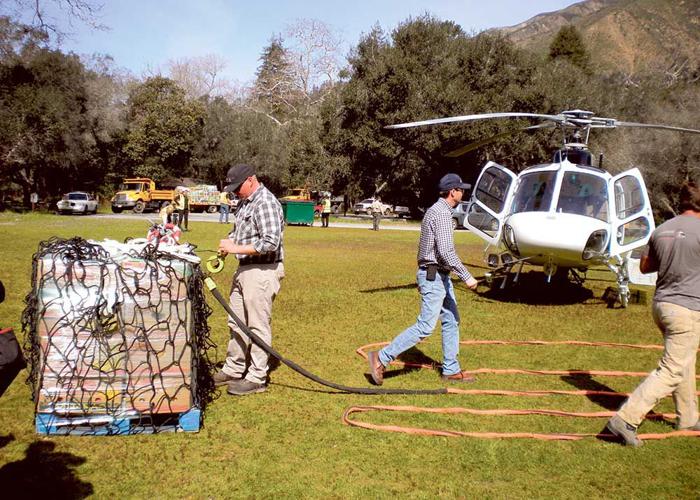
Just after 10am March 3, turkey vultures soar above the Big Sur River, searching for carrion. The sky is clear, and the sunny morning grows warmer.
About 30 minutes later, at the softball field at Pfeiffer Big Sur State Park, the distant thunder of a helicopter fills the air, and the vultures disappear. The helicopter approaches from the south, circles around the field, and makes a landing from the north.
About 30 people – State Parks and Monterey County employees, volunteer firefighters, journalists and politicians – watch the scene unfold: Vans and trucks roll onto the field, and thick-armed men quickly get to work unloading pallets of supplies to be delivered to the some 350 residents marooned on Big Sur’s “island,” who are cut off from road access to the outside world.
Gerry Malais, director of the county Office of Emergency Services, steps across the field to meet Scott Sinton, vice president of the helicopter company hired by the county, for $5,000, to deliver the supplies (paid for by residents, with the exception of diesel – which the county paid $5,700 for) to Post Ranch Inn. Minutes later, Malais says that despite getting off to a later start than anticipated, “Scott assured me there will be enough time for [all] 12 loads before dark.”
Malais says the supplies – procured through a grassroots effort led by Big Sur residents Butch and Patte Kronlund – should last about 150 people two to three weeks, and that those who didn’t order them are otherwise prepared.
County Supervisor Mary Adams, whose district includes Big Sur, smiles as she grabs a box of homework out of a van for kids stuck on the island.
The helicopter begins delivering supplies just before noon and finishes all 12 loads by 2pm. For most of the afternoon, the whir of that copter, as well another one carrying people, fills the valley.
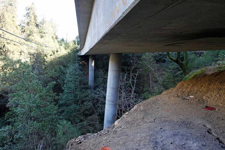
Meanwhile, the collapsing Pfeiffer Canyon Bridge on Highway 1, which is the northern border of the island, continues to sag, and Caltrans spokeswoman Susana Cruz says a crane is being shipped to the bridge in 11 pieces, where it will be assembled and used to wreck the bridge sometime next week. At Paul’s Slide, the southern edge of the island, Caltrans crews hope to have the road repaired enough by March 13 to allow for much-needed deliveries of propane.
Big Sur Volunteer Fire Brigade Chief Martha Karstens says work on a trail through state parks land is expected to begin March 9, which will provide locals a way to get on and off the island by foot.
Once the trail is done, Karstens says, “We can settle down and prepare for what our new normal is.”
3
Martha Karstens, chief of the Big Sur Volunteer Fire Brigade, has lived in Big Sur since 1971, and has seen her share of fire – and storm-related disasters. But she says the storms this winter – especially in the wake of last summer’s Soberanes Fire – have been the toughest disaster yet.
“There’s no light [at the end of the tunnel] right now,” she says. “You don’t know what to plan for.”
For at least another few weeks, a large portion of Big Sur – from south of the failing Pfeiffer Canyon Bridge all the way to Paul’s Slide, which is just south of Lucia – will remain an island, leaving around 350 residents with no road access to the outside world.
Caltrans spokesperson Susana Cruz says crews are working around the clock at Paul’s Slide in rotating 12-hour shifts to install a soil nail wall, which will stabilize the hillside, but that the situation remains dynamic.
“Dry weather after heavy rains does not mean slide activity is done,” she says. “Even after sunny weather, slides can move for up to 30 days.”
Caltrans has also been drilling into the soil around Pfeiffer Canyon Bridge as part of the process in assessing if and how a new bridge should get built, and is slated to release its investigative findings March 17.
Cruz says at that point Caltrans will know if the existing bridge is salvageable; regardless, even with Caltrans expediting the process, she estimates it will take six months to a year before the bridge reopens.
In the meantime, State Parks is doing its own assessment of the best trail route to provide pedestrian access around the bridge, but Brent Marshall, superintendent of the Monterey District for State Parks, says even that is complicated.
“There’s no trail there for a reason,” he says. “It doesn’t yield itself well to a regular parks trail.”
Marshall says portions of the contemplated route are steep, and with all the rains, the landscape is shifting.
“The physical work itself is not the challenging part, it’s finding the alignment that stands the test of time,” he says. “If things go well, it’ll be up and running in four or five weeks, but if there are more storms or slides, it’ll take a bit longer.”
To resupply groceries to those trapped on the island, the Coast Property Owners Association distributed a form for residents to create a shopping list, and the Safeway at the Carmel Crossroads has agreed to box up the orders for pick up by Monterey County Office of Emergency Services.
OES Director Gerry Malais says the county has hired a helicopter – $15,000 for six hours of time – to deliver the supplies, including diesel fuel, on March 3. But, Malais says, the county is unable to secure a helicopter big enough to resupply propane.
Sarah Davey, spokesperson for U.S. Rep. Jimmy Panetta, D-Carmel Valley, says Panetta is in talks with the National Guard to see if the military might be able to deliver fuel to Big Sur from Fort Hunter Liggett to the east.
Until roads are fixed and access to the outside world is re-established, Karstens says residents will continue hunkering down, but right now, “it’s like an abandoned community.”
“It’s an unsettling feeling,” she says. “Everybody’s lives have been affected.”
4
Travel up the narrow canyons surrounding Prunedale these days and the thick smell of eucalyptus, accompanied by the sound of whirring chainsaws echoing off the hillsides, is hard to miss.
It’s evidence of the cleanup of hundreds, if not thousands, of the non-native trees that came crashing down around North County during the storm that slammed into the region over President’s Day weekend.
Prunedale was hit with “Category 1 hurricane-strength winds” early Feb. 17, according to PG&E meteorologists, knocking out power to 9,000 residents for up to six days and temporarily blocking nearly every major road. At least 400 residents were without potable water for days, in addition to countless others on small private wells.
“North County took a huge, huge hit,” says Monterey County Supervisor John Phillips, a Prunedale resident who represents District 2, which encompasses North County. He says he hadn’t seen anything like it in his 45 years of living in the area.
Despite power outages, thousands of residents accessed social media from almost the first moments of the storm, keeping up to date. They helped each other out by offering freezer space, chainsaws, information on where to get bottled water, what roads to avoid, or lost and found animals.
Amanda Young, a Prunedale native, is an administrator of the Prunedale Neighborhood Watch Facebook page, which set up about a year ago. The group has more than 2,500 members, about 14 percent of Prunedale’s population.
Young says she and her neighbors were unprepared for the fierceness of the storm. She was also unprepared for what happened next: an equal and opposite fierce reaction of neighbors coming together like she hasn’t seen in decades.
“My phone and was blowing up with notifications from the group,” she says.
As the rain began to subside on Feb. 21, plans spontaneously erupted on the Facebook page for a community barbecue by early summer. The response was so great, Young shifted the original plan to use a smaller venue like the Prunedale Grange Hall to something bigger, possibly Manzanita Park.
As Prunedale has grown over the years, Young says the lines of communications between neighbors have waned, but the storm is bringing Prunedale back to the one she remembers growing up.
Another Prunedale native and local real estate broker, Chantel Henson, agrees: “I’ve talked to my neighbors in the last week more than I did in the year prior to that,” Henson says.

5
For people isolated in Big Sur, today is a day you can request medication refills.
The Big Sur Health Center sent out an urgent email to patients on Monday morning, letting anyone south of the closed Pfeiffer Canyon Bridge know that if they need medicine refills they should contact the center by 1pm today for a helicopter delivery on Tuesday morning.
"This requires intensive staff time, so we are trying to consolidate trips to all the various pharmacies," the email states. "Please check your supply and plan ahead. Thank you!"
The health center is located north of the closure at Pfeiffer Canyon Bridge. It was closed from Feb. 17, for a total of six business days, due to the storm. The clinic reopened at 10am Monday, says executive director Sharen Carey.
The health center receives several calls a day from trapped residents in need of medications, Carey says.
Staff members pick up the medications from various pharmacies, and a helicopter service called Specialized Aviation ferries the medications from Del Monte Aviation at the Monterey Airport—along with people and other supplies—to the fire station located at the Post Ranch Inn. Residents pick up their medications from the station.
Specialized Aviation carries the medicines for free, as long as there are paying passengers.
"All in all it has been a great team effort," Carey says.
Last summer, Big Sur Health Center staff members were active during the Soberanes Fire providing medical treatment to firefighters. The center also offered free medications and services to anyone affected by the fire, a Big Sur Health Center blog post states.
Editor's note: This post was updated with information provided by Sharen Carey.
6
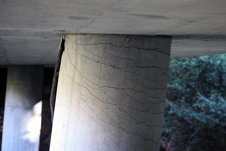
During a break between rainstorms, Caltrans and other work crews are finally able to start assessing the damage to Pfeiffer Canyon Bridge on Highway 1 in Big Sur after a landslide compromised a support column on Feb 11.
“The bridge is beyond repair,” says Caltrans spokeswoman Susana Cruz, based on a Feb. 21 structural assessment.
She says the bridge will have to come down. She estimates a replacement could take upward of a year – a long isolation for some 435 residents who live south of Pfeiffer Canyon, as well as dozens of restaurants and businesses.
North of the bridge, Highway 1 shows damage from mudslides and downed trees as crews work to clear mud and silt from the road while weather permits.
California Highway Patrol has closed the highway just south of Palo Colorado Road to the public, with the exception of work and emergency crews and residents living south of Palo Colorado Road who are allowed to travel that stretch of the highway.
The closure Pfeiffer Canyon Bridge is a hard closure and no members of the public—including pedestrians, cyclists and local residents—are being allowed through.
7
A few days after storms rocked Monterey County, causing flooding, power outages and road closures affecting thousands of residents, it finally feels like a beach day.
But all of Monterey County's beaches remain closed due to storm runoff, according to the Monterey County Health Department.
"The public is advised not to have ocean water contact at this time," according to the Health Department's advisory, which has been in effect since Tuesday.
County health officials regularly test ocean water off popular beaches, including Carmel Beach, Lovers Point, Asilomar and Del Monte Beach for fecal coliform and the bacteria Enterococcus.
Because water coming out of storm drains is more likely to contain bacteria, viruses and and chemicals, officials are encouraging people to stay out of the water until test results confirm lowered concentrations of the nasty stuff they test for.
For the most up-to-date information on beach closures, visit the Monterey County Health Department's website at www.mtyhd.org/beach or call the beach information hotline at (800) 347-6363.
8
Nearly 8 inches of rain dumped on already-saturated Big Sur coast from Feb. 18-22, and a fractured support column under Pfeiffer Canyon Bridge on Highway 1 in Big Sur continued sliding downhill.
“The bridge is beyond repair,” says Caltrans spokeswoman Susana Cruz, based on a Feb. 21 structural assessment. “The time frame for a new bridge is unknown. We have a couple of days of dry weather, which will help us.”
Numerous cracks were found in the support column on Feb. 11 as a mudslide under the bridge shifted the concrete base.
Cruz estimates a replacement could take upward of a year – a long isolation for some 435 residents who live south of Pfeiffer Canyon, as well as dozens of restaurants and businesses. Access is also closed on Highway 1 to the south of Big Sur due to slides, and Nacimiento-Fergusson Road – the only east-west paved access – is also currently closed.
“The county is working on options,” Monterey County spokesperson Maia Carroll says. The county’s goal is to do a resupply within a couple of weeks.
So far, a medevac helicopter has been set up to transport Big Sur patients in case of medical emergencies.
Palo Colorado residents are also isolated after part of Palo Colorado Road washed out. Anticipating it will remain impassable for months, the Boy Scouts of America announced they are closing Camp Pico Blanco for their 2017 summer season.
Mid-Coast Fire Brigade Chief Cheryl Getz posted a message Feb. 21 on Nextdoor.com urging residents to prepare. “If you want to move vehicles out of the canyon do it now because I don’t think that option will be available much longer,” she wrote. “The road is holding up, but it will not for long.”
According to the National Weather Service, more rain is expected this weekend.
9
In a special meeting at 8:30am Feb. 22, the County Board of Supervisors is set to extend the local emergency in two nearly identical resolutions, one of which is Big Sur-focused and asks Gov. Jerry Brown to extend a state of emergency in the county.
The move is largely a clerical requirement, as state of emergency's expire and must continue to be extended if problems persists.
Among other things, a state of emergency allows contracts to be granted without board approval, and repair work would continue to be exempt from the California Environmental Quality Act.
If Brown agrees to extend a state of emergency in the county, it will also allow the county to become eligible for state funds under the California Disaster Assistance Act.
That same resolution asks that the state continue expediting "access to federal resources and any other appropriate federal disaster relief programs."
Roads in Big Sur have been hit hardest by this winter's onslaught of atmospheric rivers, and Pfeiffer Canyon Bridge on Highway 1 in Big Sur is closed indefinitely as the ground below it shifting, causing the bridge's support beams to crack and become unstable.
Presently and into the future, businesses and residences south of Sycamore Canyon have effectively become an island, with the only access to the outside world coming by way of helicopters.
County spokeswoman Maia Carroll says the county is making "extraordinary efforts" to come up with solutions for how to help those trapped on the island until roads on the south—which have closed due to slides—open back up.
10
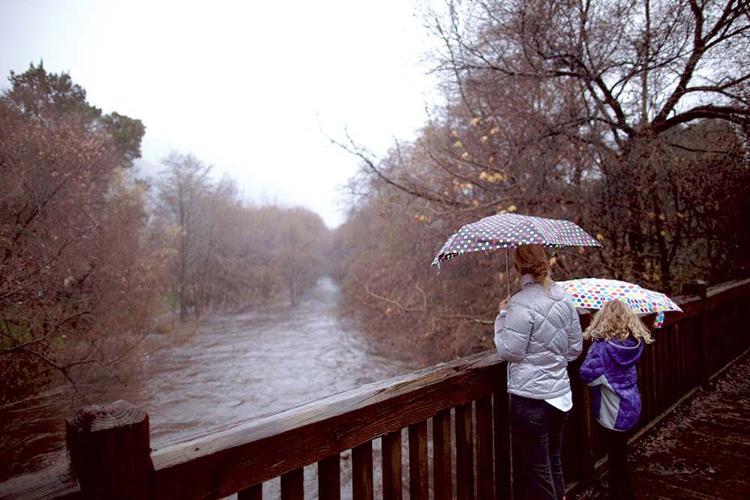
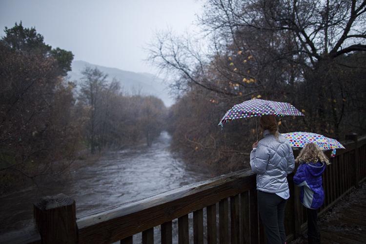
With more rain in the forecast this afternoon and evening, Carmel Valley residents who live along the Carmel River are ordered to evacuate, "as quickly as possible," according to a Monterey County announcement.
The Carmel River is expected to hit flood stage beginning at 4pm today (Monday, Feb. 20), and peak at 8pm.
The low-lying area that might be affected extends from communities along the river from the Los Padres Dam to Mission Fields.
The Red Cross has set up an evacuation center at Carmel Middle School, located at 4389 Carmel Valley Road.
Earlier Monday afternoon, residents of the Bolsa Knolls community in North Salinas were ordered to evacuate due to flooding.
An emergency evacuation shelter has been set up at the Northminster Presbyterian Church at 315 E. Alvin St. in Salinas.
11
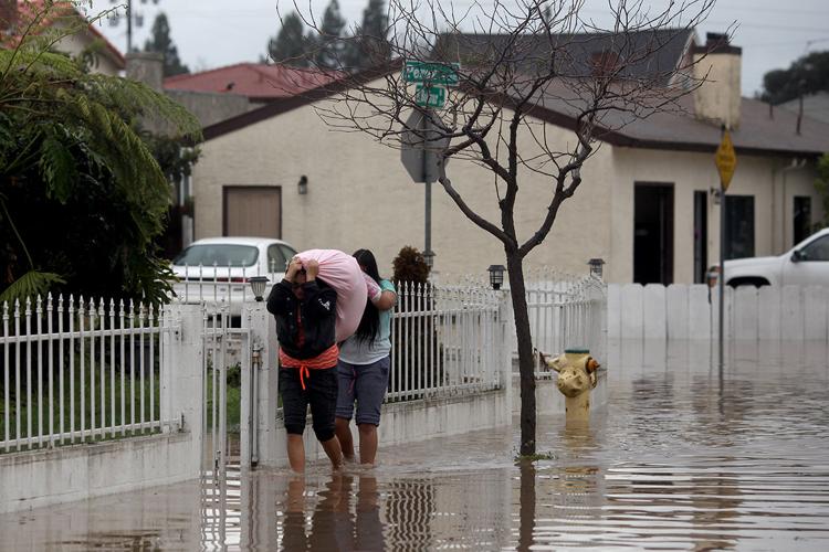
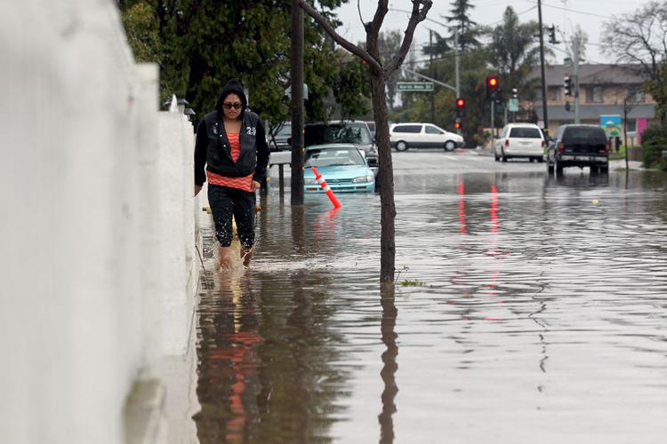
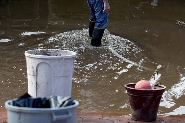
Residents in the 100 block of East Bolivar Street in Salinas awoke Monday to a few feet of water in the streets around their homes.
It didn't get much better from there, as waters continued to steadily rise as heavy storms pounded the Salinas Valley after starting late Sunday night.
At least one home was damaged by floodwaters as Salinas firefighters waded through thigh-high water to help residents.
Across town, in the 300 block of Griffith Street between East Alisal and John Streets, residents living in their RVs also waded through floodwaters rising from a nearby reclamation ditch.
National Weather Service data shows that 1.97 inches of rain fell during a 24-hour period in North Salinas from 2pm Sunday to 2pm Monday. During the same time period, 4.76 inches feel at the Three Peaks gauge in Big Sur.
As of 2:20pm Monday afternoon, residents of the Bolsa Knolls community are under mandatory evacuation orders.
The area under evacuation, according to the Monterey County Office of Emergency Services, extends from Russell Road to Bear Creek Court, just past the entrance to the Salinas Country Club, and from Van Buren Avenue to the southeast side of San Juan Grade Road.
An emergency evacuation shelter has been set up at the Northminster Presbyterian Church at 315 E. Alvin St. in Salinas.
Various water systems in North Monterey County have been disrupted over the weekend, with a sewage line break and spill reported at about 9:30pm Sunday night.
The spill is located east of McGowan Bridge near Pajaro and has been contained, but county officials expect repairs to take several days due to storm conditions.
Monterey County Environmental Health officials have posted closure signs at Zmudowski and Moss Landing beaches as a precaution due to the sewage spill.
The broken line brings wastewater from North County communities to the Watsonville Wastewater Treatment Plant.
Also in North County, Pajaro/Sunny Mesa customers on the Normco water system are under a boil-water order as of Feb. 17.
Bottled water is available the North County Fire Station No. 2 on Pesante Road; Pajaro/Sunny Mesa is also delivering bottled water to customers who can’t get to the fire station. (Affected residents can call 722-1389 for up-to-date water information from Pajaro/Sunny Mesa.)
In the tri-county region, some 10,400 people are without power as of about 2pm Monday, more than half of those in Salinas and just outside Salinas, PG&E spokesperson Tamar Sarkissian says. Nearly 900 people in Carmel are without power Monday afternoon, and 20 people in Monterey.
PG&E crews have set up two base camps to respond to weather-related outages at the Salinas Sports Complex and in Scotts Valley, and more than 2,000 employees and contractors are at work in the Northern California region, which includes the Central Coast.
There are 70 mutual assistance crews also in the area from other parts of California and as far away as Washington, Arizona and New Mexico.
Sarkissian says PG&E expects there will be more outages today due to continued rain and wind.
Road advisories are in effect in various places along Carmel Valley Road due to flooding, though the road remains open at this time.
There are advisories at Schulte Road and at Garland Park, and only one lane is currently open due to a slide near the intersection of Cachagua Road.
Pam Marino and Sara Rubin contributed to this report.
12
In the last 24 hours, heavy rains have dropped 5.5 inches in southern Big Sur, and the impact of rain and wind left more than 30,000 PG&E customers without power.
Monterey County was the hardest hit by power outages in the state, says Mayra Tostado, PG&E spokesperson.
"We're doing everything possible to return service as quickly as possible," she says. "We're going to be working around the clock and through the night."
Extra crews are coming in from around the state and PG&E put out a call to 30 mutual aid crews in neighboring states to restore power to the county.
High gusts of wind in Salinas—the National Weather Service reported one at 71 miles per hour—toppled two transmission poles around 5:30am. A substation near downtown Salinas was also affected by the storm.
Nearly 23,000 customers in the Salinas area lost power, and they remained without power Friday evening, with no known time as to when it will be restored.
According to Steve Anderson, a meteorologist with the National Weather Service, the wet weather is taking a slight break on Saturday, but will pick up again on Sunday through Monday night.
From yesterday at 4pm, other local areas received the following rainfall totals:
- Salinas - 0.58 inches.
- Big Sur Valley - 3.2 inches
- Monterey - 1.04 inches
- King City - 2.02 inches
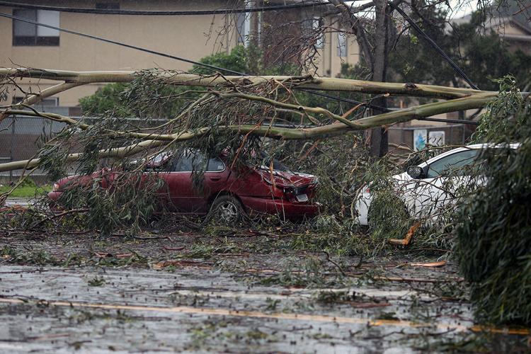
Heavy winds also tore through the Salinas Valley and Monterey Peninsula, leaving multiple trees smashed into cars and taking out power lines.
Highway 101 was closed from 8am until 2pm due to a large tree blocking all the lanes, according to a California Highway Patrol report. Highway 156 at 101 was also closed from 8am until 3:30pm.
Editor's note: This post was updated to include new information from the California Highway Patrol and PG&E.

13
Strong gusts of wind—including one clocked at 71 miles per hour in Salinas at 6am—wreaked havoc all over Monterey County Friday morning, knocking out power, felling trees and causing snarled traffic due to accidents, according to the National Weather Service in Monterey.
"We're just playing leapfrog from one call to another call to another call," California Highway Patrol spokesman Oscar Loza says.
Update at 1:10pm: Monterey County is keeping its Road Closure and Information website page updated with the latest road closure information. It includes an interactive map showing all the roads that are partially blocked or closed due to trees down, flooding, low hanging wires and more.
The area is under a high wind alert until 2pm Friday, the weather service reports.
CHP, Caltrans, PG&E, as well as local fire and law enforcement agencies are receiving a torrent of calls for everything from accidents to downed power lines, Loza says.
As of 12:50pm the CHP was reporting on Facebook that the agency has had up to 72 calls today. The post is accompanied by a photo of Highway 101 completely blocked off near Dumbarton Road in Prunedale by fallen eucalyptus trees. Caltrans crews are shown attempting to clear the trees.
"If you are stuck in traffic please be patient as we are working as quickly as possible to clear the road," the post reads.
Earlier in the day an 18-wheeler truck was blown onto its side on Highway 1 in Marina at 5:40am, Loza says, slowing down traffic for hours this morning. A tow truck was able to shove the truck into the center divide, but crews will not be able to bring the truck upright until winds die down later today. The driver was not injured.
Accidents completely blocked traffic on Highway 156, and as of 10:45am motorists were stuck on that roadway, Loza says.
In Salinas, City Councilwoman Kimbley Craig reports she's stranded in her condo complex North Main Street between Bolivar and Russell do to street closures because of downed trees and power lines.
Residents are reporting North Main is shut down near Bernal Drive due to downed eucalyptus trees, and neighboring businesses are closed.
Power lines were reported down on Kenneth Street and Avalon Place in Del Rey Oaks, says Seaside Division Chief Dave Nava. Those streets were closed off as crews worked on repairs. He says the department is getting reports of several downed trees.
"We're encouraging people to stay home and stay inside," Nava says. He emphasized that people should not touch any suspicious downed lines and call 911.
The worst of the wind will be over by mid-Friday afternoon, according to meteorologist Brian Garcia.
In addition to the 71-mile-per hour gust in Salinas, other parts of Monterey County clocked winds as high as 50 miles per hour, Garcia says.
By 8am there were reports of power outages in various spots around the county. As of 10:45am more than 5,000 customers were without power on the Monterey Peninsula. Thousands more were without power in Carmel, Sand City, Salinas, North County and Big Sur.
Monterey County announced on Twitter that offices in Salinas are closed due to the storm, including the Monterey County Government Center at 168 W Alisal St., the Health Department Offices at 100 N. Main St., the Department of Social Services at 1000 S. Main St., and Animal Services at 160 Hitchcock Rd.
A later press release also announced that the Department of Social Services Peninsula District Office and the Employment Office, both in Seaside, are closed.
Monterey County Library branches in Marina, Aromas and Prunedale are also closed for the day.
Rain is expected throughout the day, and into the evening, with a chance of thunderstorms. The forecast for Saturday is a 50-50 chance of rain and a 20 percent chance of rain on Sunday.
Heavy rain is expected to return by Monday, the weather service predicts.
Editor's note: This post is being updated throughout the day with the latest information.
14
This article, which originally appeared Feb. 15, has been updated with segments of a story by Nic Coury appearing in print Thursday, Feb. 23.
Nearly 8 inches of rain dumped on already-saturated Big Sur coast from Feb. 18-22, and a fractured support column under Pfeiffer Canyon Bridge on Highway 1 in Big Sur continued sliding downhill.
“The bridge is beyond repair,” says Caltrans spokeswoman Susana Cruz, based on a Feb. 21 structural assessment. “The time frame for a new bridge is unknown. We have a couple of days of dry weather, which will help us.”
Numerous cracks were found in the support column on Feb. 11 as a mudslide under the bridge shifted the concrete base.
Cruz estimates a replacement could take upward of a year—a long isolation for some 435 residents who live south of Pfeiffer Canyon, as well as dozens of restaurants and businesses. Access is also closed on Highway 1 to the south of Big Sur due to slides, and Nacimiento-Fergusson Road—the only east-west paved access—is also currently closed.
“The county is working on options,” Monterey County spokesperson Maia Carroll says. The county’s goal is to do a resupply within a couple of weeks.
So far, a medevac helicopter has been set up to transport Big Sur patients in case of medical emergencies.
The first piece appears here:
If one wanted to have, say, a nice craft beer and a taco at Big Sur Taphouse, or a famous ambrosia burger and South Coast margarita at Nepenthe, or some Black River caviar at Sierra Mar, they'd have to really want it.
(And, in the case of the caviar, they'd have to have $225.)
That's because of two major road closures that have reduced Big Sur proper to a coastal island-of-sorts.
Then Nacimiento-Fergusson Road south of Lucia was shut down because the road is sliding down the cliff.
Don't worry—99.9 percent of Big Sur types know what they signed up for when they moved there or started work down south. At least if they didn't, they know now.
But to get that food and drink, one would have to park on the north side of the blockade and hike a mile to reach Big Sur Taphouse. (There is beer flowing, and food sizzling, because Taphouse staff can cart supplies along that corridor via dolly, wheelbarrow and backpack.)
(Or at least that is the status quo. From 10am-1pm cars can cross the bridge one-by-one, under Caltrans supervision.)
If they had a friend with a car on the other side—or really wanted to hike—they could make it to Nepenthe.
Only there's no food being served there.
Nepenthe is closing operations until at least March 1 to give employees a chance to regroup and find steadier work elsewhere while its family hunkers down without the ability to move propane or trash, let alone edible and potable supplies.
"When we can't get food or drink or people here safely," Manager Alicia Hahn-Peterson says, leaving the thought to trail off.
March 1, considering oncoming storms, dynamic slide conditions and who-knows-what-else-on-the-way, seems optimistic. Certain experts arriving to consult on the safety of various roads and bridges aren't expected until next week.
Most all of the businesses on the South Coast—and a lot of people—are hurting financially from two months essentially dark from the Soberanes Fire caused by an illegal campfire.
Hahn, like the wider Nepenthe family, is most concerned for her employees, and wants to alert all Peninsula restaurants in need of skilled, well-trained front and back of the house staff so that she can connect them.
Her email is ahahn@nepenthebigsur.com
"We're prioritizing our employees," she says. "It's my first year as a manager and it's been intense—the fire, then this."
"The family has had a plan for this sort of this thing," she adds. "Other people are doing some soul-searching, [asking,] "If I'm on this side am I prepared to stay?"
Nepenthe's place at the heart of Big Sur resilience—and community—was a major theme of the cover story I wrote on its 60th anniversary, "It’s a Sur Thing: Nepenthe still swinging as it turns 60," as this passage attests:
When a split-second of silver in the summer sky and years of golden-brown on the ground collaborated to stoke a fire hungry enough to gnaw up more than 160,000 acres – and to chew within 30 feet of Highway 1, right up the road from the old restaurant – it wasn’t Nepenthe’s first folk dance with disaster.
El Niño (1983 edition) shoved mudslides down the Santa Lucia range and onto Highway 1, closing it in both directions for 10 weeks (and south access for months longer). Its ’98 reincarnation did much of the same. Meanwhile, Kirk Complex, Rat Gorda Complex and Marble Cone fires sufficiently rattled Big Sur’s soul (and infrastructure).
The chaos brought them closer, which isn’t easy. Nepenthe and Big Sur have been indecipherable since Bill Fassett coined its early motto when ambrosia burgers were still 60 cents: “In Big Sur it’s Nepenthe – ask anybody.”
“It’s hard to imagine Big Sur without it,” says Stan Russell, Big Sur Chamber of Commerce executive director. “It’s such a critical part of the heart of Big Sur. If it didn’t exist it would have to be invented.”
“A rare structure, a rare family, a rare approach in this rare place,” Big Sur Lodge guide Jack Ellwanger says. “They’re really at the heartbeat of the coast.”
15
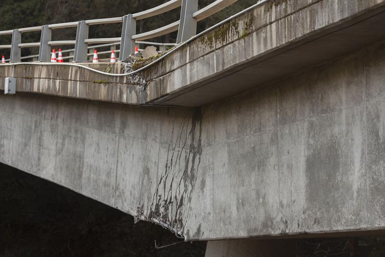
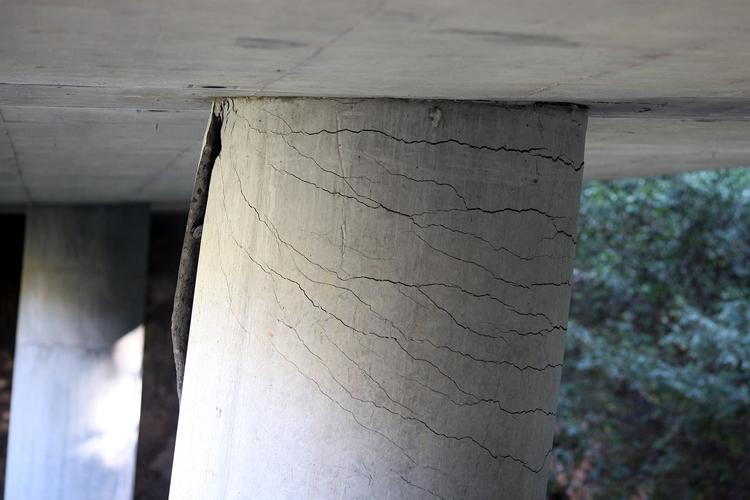
Cracks in a support column under the Pfeiffer Canyon Bridge on Highway 1 in Big Sur continue to grow, causing an indefinite closure of the road.
At 5pm on Wednesday, car and pedestrian traffic were stopped completely. Caltrans crews plan to reassess the bridge’s stability on Feb. 21, but there is no guarantee the bridge will open again on that date.
“It’s a situation that is still evolving,” says Caltrans spokesman Jim Shivers. “It’s too soon to know if the bridge will need to be replaced.”
Recent rain caused a landslide on the west side of Pfeiffer Canyon, pushing mud and soil downhill—and under the bridge. That moving earth shifted the middle bridge support column, according to a Caltrans official surveying the damage Wednesday. As the base of the column moved downhill, the top started to crack and fracture.
Caltrans officials are worried that the coming rains will cause further damage.
Rain started to fall again in Monterey County late Wednesday night, which caused a closure of the bridge to through traffic.
“We simply need to see what happens next,” Shivers says.
Nacimiento-Fergusson Road is also currently closed, leaving many Big Sur residents without any paved to access the Monterey Peninsula or the Salinas Valley.
16
Update as of 5:30pm Wednesday: California Highway Patrol has announced the Pfeiffer Canyon Bridge is closed indefinitely after a CalTrans assessment on Wednesday afternoon showed growth in the support column fractures.
There will be a further assessment on Feb. 21.
Update as of 2pm Wednesday: The last chance to cross the bridge either by vehicle or foot is 5:00pm Wednesday.
Big Sur residents stuck on the southern end of damaged Pfeiffer Canyon Bridge may get a chance to move their vehicles one-at-a-time across on Wednesday—that is if Caltrans deems it safe to do so.
"This afternoon's bridge inspection showed even more movement and growth in fractures [to the bridge support column]. For the sake of the locals, vehicle/pedestrian access will be allowed through one last time from 2pm to 5pm," states a Caltrans announcement.
"This will be the last time pedestrians, vehicles and emergency services will be allowed across the bridge until further notice," it states. "The next bridge assessment will be made after the rain, on Tuesday, Feb. 21."
Update as of 9:30am Wednesday: Vehicles will be allowed to cross from 10am to 1pm, according to a Caltrans announcement.
"This morning's bridge inspection showed movement and growth in fractures, but vehicle/pedestrian access will be allowed this morning," the announcement states.
An additional bridge assessment will be conducted at noon to decide if vehicles will be allowed from 2pm to 5pm. Officials promised a new announcement at 1pm.
The bridge was closed to all vehicle traffic on Sunday, after it was discovered one of its support columns was fractured due to the shifting hillside underneath. Only pedestrians were allowed to cross.
At 9am on Wednesday the agency will assess damage to the bridge's support structure and decide if it can allow some vehicles to cross, according to a statement released by Caltrans spokesperson Susana Cruz on Tuesday afternoon.
"Expect the 'go ahead' or the 'cease operations' update at 9:30am," according to the statement.
If the bridge is deemed safe enough, vehicles up to 20 tons will be allowed to cross one at a time escorted by the California Highway Patrol during two sessions, from 10am to 1pm, and 2pm to 5pm.
"These provisions are for critical and necessary trips on this day only," the announcement states.
Pedestrians will also be allowed to cross the bridge, but Caltrans says it is closing the bridge completely on Thursday morning, when a new storm is expected to hit the area.
Editor's note: This post is being updated with the most current information from Caltrans as it is released.
17
A couple of fractures in one of the two support columns for the Pfeiffer Canyon Bridge prompted Caltrans to close the bridge on Highway 1 to all traffic as of 5pm Sunday, according to a spokesperson.
Only pedestrians and emergency vehicles are allowed to cross the bridge until further notice. However, an incoming storm on Thursday could shut the bridge even to pedestrians for the duration of the rain, officials announced this afternoon.
Caltrans will not know until later this week the extent of the damage to the bridge caused by the shifting hillside, says Susana Cruz, acting manager of the Caltrans public information office in San Luis Obispo.
The fractures were caused by the rain-soaked hillside shifting beneath the bridge, which is located near Sycamore Canyon Road. Specialized equipment is needed to measure the size and depth of the slide and will not be available to geotechnical crews for at least couple of days, Cruz says.
There currently is no timeline for when the bridge will re-open to vehicles.
"We don't have a short term or long term plan until we can get a full assessment," Cruz says.
Earlier on Sunday, Caltrans was escorting vehicles one at a time across the bridge headed north.
Residents and visitors who needed to travel north after the closure were encouraged to park their cars at the Pine Ridge Trails parking lot, then walk back across the bridge.
Highway 1 continues to be closed between Ragged Point in San Luis Obispo County and Pfeiffer Canyon Bridge, due to multiple mudslides that occurred since rainstorms began hitting the coast in late January.
The highway is impassable between Ragged Point and Dolan Point, according to a Caltrans statement issued at 1:55pm on Sunday.
Caltrans officials recommended that if any residents or visitors wanted out of the section between the two points, their only option was to move their cars north of the bridge, and “be escorted by businesses to and from destinations south of the bridge.”
Businesses remain open, the statement said.
The water-logged hillsides will get to dry out a little between today and Wednesday, before rain is expected to return. The National Weather Service is predicting a 90-percent chance of rain on Thursday, with more rain on the way throughout the weekend.
In an announcement made at 3:50pm, Caltrans warned residents the storm could mean closing the bridge completely for its duration.
"It is unknown how the bridge will sustain itself or whether pedestrian traffic will still be available. The bridge may need to be completely closed for the duration of the storm; safety precautions/preparations are advised."
Editor's note: This post was updated to reflect the latest information from Caltrans as of 1:45pm and 3:50pm Monday.
18
After over a foot of rain dropping on Monterey County in January, seasonal storms continued during the second week in February with more rain expected.
According to Mark Strudley, a hydrologist with the National Weather Service, from Wednesday morning through Friday morning, Big Sur received 2.9 inches of rain. Monterey and Salinas both received just over 1.1 inches.
As of Friday afternoon, blue skies and sun can be seen peeking through the clouds.
“We expect it to be dry throughout the weekend and into early next week,” Strudley says.
But the rain will be back.
“This will be a decent amount of rain,” Strudley predicts. “It looks to not be a light rain event.”
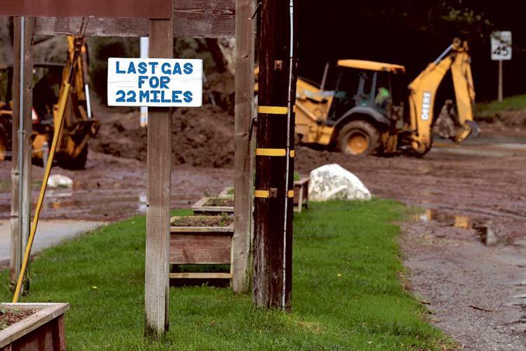
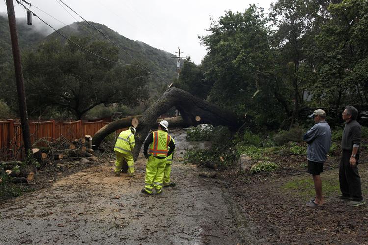
In Carmel Valley on Friday morning, crews from Monterey County Public Works cleared a large oak tree that fell across Paso Hondo near the Carmel River. The tree, which fell around 1:30am on Friday, took out cable lines and smashed a mailbox.
Down the coast, Highway 1 is still closed from Ragged Point on the south end to Nepenthe Restaurant in Big Sur.
“Even though the rains stopped, the slides have not,” says Susana Cruz, a Caltrans spokesperson.
The area most severely affected in Big Sur is Paul’s Slide at mile-marker 21.6, where the southbound lane of Highway 1 has started to slide into the ocean.
“It is moving faster than we can stabilize it,” Cruz says. “Once they are able to contain the slide, we will have geologists to make an assessment.”
19
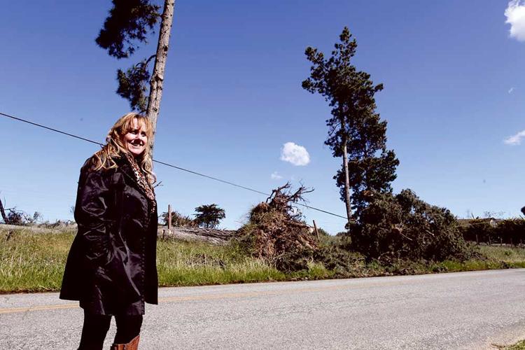
It’s Feb. 6, just after 4pm on Palo Colorado Road, and Richard Gorton, a Palo Colorado resident and off-duty Cal Fire firefighter, drives his pickup east up the storm-torn canyon. Along the way, branches, trunks and freshly fallen trees line the steep banks of Palo Colorado Creek.
The canyon is gloomy under a darkening sky, and another wet storm is just hours away. Gorton points out a spot in the creek where silt – and the remains of a ’57-or-so Chevy that came from up the hill – stopped up in a tangle of trunks and drove water and mud up onto the road.
“The ground is at such a saturation point with all that fire damage,” he says, referencing the summer’s Soberanes Fire. “There’s not vegetation to hold everything together.”
When he passes over the saddle by the Mid-Coast Fire Brigade station, he points out a private road to his left and mentions a lot of people on that road lost their homes to the 132,127-acre fire. The area’s burn scar is also sending sediment down the creeks.
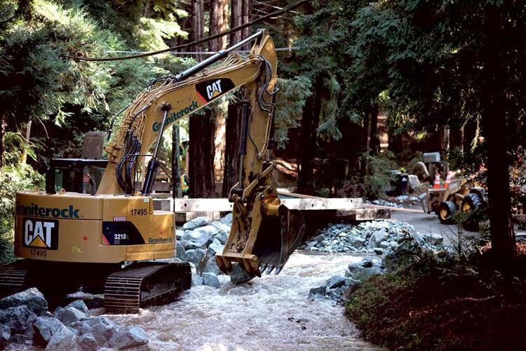
Horton parks just before the 3.3-mile mark, where a county public works crew is preparing to remove a temporary bridge over Rocky Creek where January storm runoff caused the road’s culvert to fail.
Crews installed the bridge a week prior. They decided to take it out when the National Weather Service changed their forecast and sent out an flash flood warning around 2:30pm.
Juan Mesa, a construction specialist with county public works, stands next Mid-Coast fire chief Cheryl Goetz as an excavator pulls off one of three steel planks over the creek.
“We want to put it back as soon as possible, that’s the plan,” Mesa says.
“What’s really nice is I’m on conference calls with them to make sure we didn’t shut the road down until all the school kids got home,” Goetz adds.
Gorton, meanwhile, points out two driveways – one where his girlfriend lives – that are now creekfront property, and impassable for cars.
Palo Colorado is certainly not the only place with roads hit hard by this winter’s unrelenting storms. As this story went to print, 14 county roads were closed indefinitely.
Near the Elkhorn Slough National Estuarine Research Reserve, Kirby Avenue is completely shut down and Elkhorn Road is closed south of the reserve.
“It seems to be high-priority with the county,” says Reserve Manager Dave Feliz, “but realistically, it’s still raining, it’s not getting better and they can’t start until things calm down.”
Feliz says part of the problem in the area is an “incredible” amount of sediment runoff from strawberry farms, which runs over the road, into the reserve and ultimately the wetlands.
“We’re concerned about that,” he says. “Landowners really need to manage their sediment onsite, because now it’s going to cost $1 million [to fix the road] in this particular spot.”
Caltrans reported a fresh slide on Highway 1 in Big Sur Feb. 7 at Cow Cliffs, and existing slides again became active.
“This is just a problematic area,” says Caltrans spokeswoman Susana Cruz, who says crews have backed out of the slide areas until the storm passes. “It’s still very active, and crews will not touch it until it stabilizes.”
20
Less than a week after a quadruple shooting in Salinas that left two men dead, the Salinas Police Department is busy investigating an officer-involved shooting early Wednesday morning that left a 16-year-old boy dead.
More rain is expected for Monterey County this weekend after last week's heavy storms.
View more feature photos everyday on the Weekly's Instagram feed at: www.instagram.com/montereycountyweekly
21
It was around 9:30pm on Jan. 8 when Carmel Valley resident Gary Briant, who was working on his motorcycles, saw water coming in under his garage door.
Despite the recent rains, Briant, whose home is on Paso Hondo and just adjacent to Dampierre Park, didn’t think he had cause for concern – he had been keeping an eye on the the Carmel River, and didn’t think it was rising toward his home. But as the water continued coming into his garage, Briant decided to investigate.
“I opened the front door, and I could see basically a river flowing through our yard,” he says. “It was one of most helpless moments, seeing the water level rise and you can’t do anything about it.”
As their three young boys were asleep upstairs, Briant and his wife, Andra, began shuffling their valuables in the garage to higher ground. Also on the ground floor are a bathroom and guest room, which Briant “wrote off” completely.
On the advice of firefighters who stopped by the house about a half-hour after the flooding began, he and Andra moved their cars to higher ground. Sometime between 1am-2am, firefighters urged them to evacuate, and they helped carry the kids through 2 feet of water.
Andra left, but Briant decided to stay.
He rented a pump the next day and pumped the water out of his home. Thankfully, he didn’t return the pump.
“Early Wednesday morning, around 2am, a firefighter started banging on the door,” Briant says. “He says, ‘Get up, it’s happening again.’”
Around 5am, when Briant felt like the water wasn’t going to get any higher, he turned on his pumps and started all over again.
Just downriver from the Briants’ home, Kate Daniels – chief of staff to the new District 5 County Supervisor Mary Adams, who was sworn in Jan. 10 – saw her garage start flooding on Jan. 11. It wasn’t from water that jumped the riverbank – it was literally spouting up from cracks in the ground like a series of drinking fountains she couldn’t turn off.
They’re called “boils,” Daniels says, and a fire captain told her they occur when storm debris causes blockage on the river and the water has nowhere else to go.
“For the entire day there were fissures spouting in our garage,” she says.
Daniels rented a pump, ordered a dumpster and got to work.
In all, at least 10 homes were flooded, five of them severely, on Paso Hondo and the surrounding area, in a week where local rivers flowed mightily.
~ ~ ~
As heavy rains persisted for days, Gerry Malais, manager of Monterey County’s Office of Emergency Services, worried there could be severe flooding along the Big Sur River. Debris like fallen logs has the effect of creating dams along the river, forcing the water to overflow the banks.
But the flow was so extreme, it actually helped minimize problems: “The Big Sur River was so violent, it dislodged downed redwoods,” Malais says.
Twenty miles north, from Jan. 9-12, about 21,500 acre-feet of water flowed out of the Carmel River to the sea, says Monterey Peninsula Water Management District General Manager Dave Stoldt. Due of a mix of conservation and the increasing price of water on the Peninsula, Stoldt says the annual demand in the region’s California American Water service area has held at about 10,000 acre-feet annually. That means, in just four days, enough water flowed into Carmel Bay to supply the Peninsula for about two years.
But there is no existing way to capture that water because, as Stoldt brings up, Peninsula voters shot down a proposal in 1995 to build a new dam, below the existing Los Padres Dam, to create a reservoir with a capacity of 24,000 acre-feet.
But not all the Carmel River water is being lost: Stoldt says the rains have allowed more than 230 acre-feet of surface water to be pumped into the Seaside aquifer for storage, which can only happen when a variety of conditions are met.
He adds, however, that the existing Los Padres Reservoir started to spill over Dec. 16, exceding its limited 1,670 acre-feet capacity.
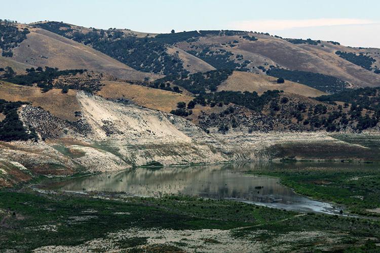
In all, it’s a paltry amount compared to the volumes that are flowing into the ocean, especially when comparing it to the amount of water coming into the South County reservoirs – Lake San Antonio and Lake Nacimiento – since the beginning of the year.
On Jan. 1, Lake San Antonio held 21,150 acre-feet of water and was only at 6-percent capacity. By Jan. 17, it held 48,050 acre-feet and was at 14-percent capacity. During that same time, Lake Nacimiento went from holding 93,275 acre-feet at 25-percent capacity to holding 218,110 acre-feet, reaching 58-percent capacity.
In other words, in less than two weeks, the amount of water in each reservoir more than doubled. Nevertheless, neither reservoir is anywhere near being full.
All of that water came from streams flowing out of the Santa Lucia Mountains, which got dumped on during the recent storms, with some parts of Big Sur seeing more than a foot of rain from Jan. 6-8.
The wettest place in the county has been at the Three Peaks gauge in southern Big Sur, which saw 34.5 inches of rain from Jan. 2-12.
A report from the National Weather Service’s San Francisco Bay Area/Monterey office – which covers roughly from Fort Bragg to Cambria – on impact of the January storms on the region, states: “The beginning of 2017 started off with rain in the blockbuster department. However, as the old saying goes, ‘You can have too much of a good thing.’”
The saturated mountains, while a good thing with respect to the drought, have predictably led to landslides and closures on Highway 1. To date, the January storms have caused four slides that have closed at least one lane. By Jan. 16, two of the slides had still not been cleared, and the southernmost slide, at Mud Creek, just 8.8 miles north of the county line, is impassable.
Susana Cruz, a spokesperson for Caltrans, says it’s not yet known when that slide will be cleared, and that it will require an engineering project to be built – like a bridge, or a retaining wall or rock netting to stabilize the hillside – before Caltrans will open it back up. Cruz says the hillside at Mud Creek remains unstable, and technical crews are currently assessing the best project to undertake.
In all, though, she says, past engineering projects have greatly helped stabilize hillsides on Highway 1, and that – compared to the damage some past storms have done to the road – “This is like nothing.”
More storms are in the forecast, however, and Cruz says how the highway will fare is hard to predict.
“You’re living by Mother Nature, and she does what she wants,” Cruz says.
~ ~ ~
Though there was a flood warning in place in North Monterey County near the Salinas River mouth and along the Pajaro River, no region in the county has been more impacted by the storm than District 5, which stretches from Big Sur to Monterey.
For brand-new County Supervisor Mary Adams, that means it’s been a trial by storm.
Adams says that because of the relationships she and Daniels, her chief of staff, developed in the community after she was elected June 6, she knows who the local leaders are and has been in regular contact with them.
“We’ve been able to function as a conduit,” she says, adding that throughout the storms she repeatedly received text messages from her constituents about road and flood conditions, and that she would send the information along to the relevant agency to handle it.
“What am I going to do? Go out there with sandbags?” she says. “That’s not the idea. I need to make sure county offices know where to pay attention.”
She’s also been contact with Briant, and adds that she formerly lived on Paso Hondo for decades – and during that time it never flooded past half the field at Dampierre Park.
At Briant’s home on Jan. 15, scores of the family’s belongings are drying out in the sun, where they will remain until an insurance assessor can document them.
He shows the dark ring left by the water about 2 feet from floor in the garage, and explains that all the drywall will have to be torn out so that the studs in the wall – two-by-fours – can dry out. His water heater and furnace were destroyed, he adds, leaving him without hot water for at least a few weeks.
In his backyard, next to his small pool, he explains that he needs to have the water tested to see if it’s contaminated, and laments how the damage on his property beyond the footprint of his house – including his septic tank, fences and driveway – is not covered by his Federal Emergency Management Agency (FEMA) flood insurance.
Then he leads the way into his backyard and heads east, toward where the river jumped the banks, where a wall of sandbags is covered in white sheet plastic. Crews from Gabilan Camp, a prison in Soledad housing inmate firefighters, put the bags out following the flooding on Jan. 9, but they failed to prevent the second flood.
“Sandbagging is a band-aid,” Briant says. “The solution needs to be something more permanent.”
Briant, who grew up in the area, says when he was younger the river wasn’t so overgrown, and that vegetation was regularly cleared to help prevent flooding.
The current state of affairs, he believes, is due to groups, agencies and regulations that put people’s needs “at the bottom of the totem pole.”
On the way back to his house, he says it will cost him a lot of money to fix all the damage, particularly given how much his FEMA flood insurance won’t cover.
“Even if we wanted, we can’t buy enough insurance,” he says. “There’s literally no way to cover ourselves.”
More rains were forecast, meanwhile, in just a few days.
NWS meterologist Anna Schneider predicted a series of three storms would move into the area Jan. 18, bringing rains through the weekend and beyond.
But unlike the deluge of early January, these storms are drier and will move faster, she says, and only about 3.5-5 inches of rain are predicted for Big Sur. About half that is expected for Carmel Valley.
22
The week-long rains dropped a lot of water in Monterey County and caused flooding in Carmel Valley after the river overflowed on both Sunday and Tuesday.
On Tuesday, two new county supervisors, Mary Adams and Luis Alejo, were sworn in.
Salinas suffered their third and fourth homicides on Thursday night after a quadruple shooting in the 500 block of Sunrise Street.
View more feature photos on the Weekly's Instagram at: www.instagram.com/montereycountyweekly
23
Despite all the rainfall brought by this winter and the last, Monterey County's two reservoirs entered 2017 in a relatively dismal state.
But that is quickly changing.
On Jan. 1, Lake San Antonio was filled to only 6 percent of its capacity, while Lake Nacimiento was at 25-percent capacity.
Just more than a week later, on Jan. 10, Lake San Antonio is at 11 percent and Lake Nacimiento is at 43 percent.
Considered another way, Lake San Antonio went from holding just 21,150 acre-feet of water—for context, the Cal-Am service area in the Monterey Peninsula has an annual demand of 10,000 acre-feet—to holding 37,500 acre-feet.
Lake Nacimiento, meanwhile, went from 93,275 acre-feet in storage to 163,827 acre-feet.
With more rain in the forecast for this week, and with the continued flow of water out of the watersheds, those numbers should continue climbing.
--
Clarification 1/12/17: This article was changed from its original version to reflect Cal Am's service area more recent annual demand of 10,000 acre-feet, as opposed to 13,291 acre-feet.
Additionally, this article omits the Los Padres Reservoir, which has a meager 1,670 acre-feet of capacity.

24
As blue skies and sunlight peered through dark gray rainclouds over Carmel Valley on Monday morning, residents on Paso Hondo pulled water-damaged possessions out of garages as disaster cleanup crews pumped floodwaters into the street. Firefighters from Monterey County Regional Fire talked with the residents who were under voluntary evacuation.
Workers from the Monterey Peninsula Regional Park District assessed the Carmel River, which was running heavily behind the little league baseball diamond on Dampierre Park behind the flooded homes.
The first report of severe flooding came in to the Monterey County Office of Emergency Services around 9:30pm Sunday night. OES officials first called for a mandatory evacuation of the neighborhood, but arrived at the scene and downgraded it to a voluntary evacuation based on the scale: Ten homes were flooded, five of them severely.
Two residents evacuated, one hospice patient was relocated to a hospital, and one elderly resident was relocated to her son’s home, according to OES Manager Gerry Malais.
County officials set up an evacuation shelter at Carmel Middle School, but no Paso Hondo-area residents were using it; it was occupied by three homeless people and two dogs, Malais says.
More rain is predicted Monday and Tuesday, but Malais says the Carmel River flooding event—which ended around 2am Monday morning—is likely over. “It’s receded 2 feet already,” he says, “so the water isn’t anywhere near the bank.”
25
After a weekend storm delivered consistent rain and wind to the region, dropping 13 inches on high peaks in Big Sur, a mudslide led to the closure of Highway 1 in Big Sur.
The slide happened about two miles south of Ventana Inn, and the highway is closed in both directions from Ventana to Ragged Point, just south of the county line. Caltrans reports several smaller slides between those two points.
“Mother Nature takes it toll and we can only do so much,” says Caltrans spokesperson Susana Cruz.
Late Sunday night and early Monday morning, Jan. 9, the Carmel River rose above a levee, flooding a baseball field and 10 Carmel Valley homes along Paso Hondo, at the edge of Carmel Valley Village. Two people were evacuated from flooded homes in the middle of the night, according to Gerry Malais, manager of the Monterey County Office of Emergency Services.
The evacuation was voluntary, and one evacuee was a hospice patient who was relocated to a local hospital. The other was an elderly woman who went to stay with her son.
County officials set up an evacuation shelter at Carmel Middle School. The only people who showed up were three homeless people and two dogs, Malais says, not residents of the Paso Hondo area.
County emergency officials are continuing damage assessments throughout the day, and this post will be updated with more information as it's made available.
Monterey County Public Works is also reporting several road closures, due to flooding, as of Monday morning.
In Carmel Valley, Boronda Road is closed at the intersection with Garzas Road. Roads in the Paso Hondo and Cresta neighborhood are open only to residents, Carroll says.
In the Salinas area, South Davis Road is closed from Hitchcock to Reservation, Old Stage Road is closed near Natividad Road and San Juan Grade Road is closed from Rogge to Stirling.
In Prunedale, Echo Valley Road has one lane open and traffic is moving slowly.
Just south of the county line, Trafton Road, near the banks of the Pajaro River, is closed to traffic.
"We want people who live near waterways to be mindful of their surroundings," Carroll says. "We saw over the weekend the problems it can create."
Sandbag pick-up locations are posted on OES winter preparedness page.
26
A wet weekend in Monterey County dropped nearly a foot of rain in Big Sur.
According to NOAA meteorologist Steve Anderson, the rain levels were about what was predicted last week.
The rainfall from Friday morning to Sunday night was:
Big Sur mountain ranges - 13 inches
Big Sur Village - 10 inches
Monterey Peninsula - 2.2 inches
Salinas - 1.8 inches
North County (Moss Landing and Prunedale) - 1.8 inches
“We have some more rain coming back on Tuesday in small amounts,” says Anderson. “Coastal Big Sur should expect another inch.”
After Tuesday, Jan. 10, Anderson says the rain will subside and the weather will dry out by this coming weekend.

27
Tuesday night’s storm dropped upwards of a foot of rain in the Big Sur mountains, but the National Oceanic and Atmospheric Administration says that is minimal compared to heavy rains expected for this weekend across Monterey County.
According to NOAA meteorologist Roger Gass, residents should expect a three-day rainstorm starting Friday morning pouring upwards of 16-inches on the county.
“It’s a pretty potent atmospheric system, so it’s a more than a standard storm,” says Gass. “If it keeps to its potential, it could been one of the biggest storms we’ve seen in awhile.”
According to NOAA, the urban areas of Monterey and Salinas could see two to three inches of rain.
While rain is welcome for the drought-stricken state, Gass says a lot of rain in a short timeframe could cause problems.
“We definitely expect an increase in flash floods and rock slides across the region,” he says. “Overall we’re going to be a little bit of a mess this weekend.”
As of Wednesday afternoon, Caltrans reports a full road closure on Highway 1 at Fuller's Point in Big Sur due to crews removing a slide. The closure is expected to be cleared by 6pm on Wednesday.
28
The other day some opportunistic Big Sur locals took the occasion of ongoing Highway 1 closures to pour Champagne on each others heads—in the middle of Bixby Bridge.
Not everyone is having quite so much fun with the landslides and collapsing bridge, but some are turning adversity into opportunity, including Big Sur Bakery.
Their weekend pop-up in Carmel—or as they're calling it, "pop-over"—is only one of a number of Big Sur updates worth mentioning, many of them restaurant and hospitality-industry related.
Meanwhile a report out today (March 9) from David Schmalz, "Flown In: Residents and officials come together to aid Big Sur," details how helicopters are helping 350 residents trapped on the "island" get their food, medicine and homework.
And as this goes live, a team of Carmel Unified School District employees arrived by helicopter to the Post Ranch yurt to introduce a special team and a teacher to address needs and concerns relating to local kids' education during the bridge outage.
Other updates appear here:
• Pastry Chef Ben Spungin (Post Ranch Inn) and Matt Somerville and Michelle Rizzolo (Big Sur Bakery) are "popping over" to Salumeria Luca in Carmel on Saturday and Sunday, March 11-12. From 10am until everything sells out, eager eaters can get BSB's morning pastries, croissants, bacon bow-ties, ginger scones and sourdough loaves. Spungin will do his fine chocolates and ice creams. Some proceeds will be donated to the Big Sur community. "It's the only time I've baked this far North on the coast," Rizzolo says.
• The Relay for Rachael team, led by a number of Nepenthe staff including Aengus Wagner, is on track for another inspiring Big Sur Marathon fundraiser for Rachael Short. (The race will continue with its usual route because the impassable roads are south of its path.) "As Big Sur is trying to recover from the latest barrage of Mother Nature's fury, some of us are lucky enough to be running on the highway and in the hills with no one around," Wagner says. "It's kind of conflicting because of the hardship on the businesses and families but so nice to experience the coast without the 'normal' traffic."
• Speaking of Nepenthe, here's the word from manager Alicia Hahn Peterson: "We would like to open April 1 (not joking) pending public access on Highway 1 to the south. Also still awaiting word for bypass pedestrian trail possibilities around the bridge closure, first to locals and then possibly public. [Nepenthe owner-operator] Kirk Gafill has been working closely and continuously with all agencies to do all that is possible for our community and personnel. There is a core team (including Kirk) holding it down on the Nepenthe property and a few of us here at an office in Carmel staffing 'Nepenthe Office North' to provide support for our staff and keep engines warm anticipating reopening. There is still some talented front and back of the house staff that may be seeking employment here on peninsula, so continue to email me at ahahn@nepenthebigsur.com with available positions and opportunities."
• Sierra Mar, the landmark restaurant at Post Ranch Inn, has furloughed most of its staff until things open back up.
• Esalen has had to cancel workshops and close its doors to guests since Feb. 12. This closure holds through the April 14-16 workshops, after which the retreat center hopes reliable road access from the south will allow it to reopen.
• At the storied New Camaldoli Hermitage, the community of monks remains stranded due to the storms. A GoFundMe campaign created for the New Camaldoli Hermitage has raised more than $145,000 to help the hermitage recoup lost income and rebuild their beautiful retreat.
• A collection of Big Sur and storm-related stories including "Island Living: Many in Big Sur remain cut off from the outside world, and solutions are weeks away" can be found with the Weekly's 2017 Winter Storms.
• Big Sur resident Matt Glazer is doing a night of soul food Monday, March 13, at High Treason at 443 Element St. in San Francisco to benefit the Big Sur Community Relief Fund.
• A final Big Sur bonus nugget: Precisely 10 years ago this week, I described the life-and-death battle and brilliance of Palo Colorado poet Ric Masten with "Death and the Poet: Nearing the end of a singular life, Ric Masten embraces the thing that will kill him." His words and spirits remain with the coast, particularly in times like these, even as he has passed on.
The truckloads of wood and brush just didn’t seem to stop coming March 4 to the Marina landfill. By the end of the day, 150 tons of yard waste had rolled through its gates, the equivalent of 15 garbage trucks. It was the largest single day of green waste disposal in the 65-year history of the dump.
Since a massive storm hit Monterey County Feb. 17-21, the tonnage numbers racked up by the landfill are staggering: 7,580.83 tons of green waste between Feb. 18-March 4, the equivalent weight of more than 2,500 Asian elephants and a 181-percent increase over the same time period last year, according to Jeff Lindenthal, Monterey Regional Waste Management District’s director of communications and sustainability.
“We’re having trouble chipping it fast enough,” Lindenthal says. The district is making plans to bring a new state-of-the-art wood chipper online in the coming weeks to help with disposal. In the meantime, the landfill’s on-site composter, Keith Day Company, is helping grind up surplus debris.
With even more tree and brush debris expected, officials are struggling to meet demand and dispose of it quickly – without causing damage to the environment. A prime example is in Prunedale, where hundreds of eucalyptus, pine and oak trees fell, and where it’s common practice to burn tree debris.
But smoke from burning debris in the many canyons of North County could pose a serious health risk, says Richard Stedman, air pollution control officer for the Monterey Bay Air Resources District. Soon after the storm, Stedman began investigating how to get wood-chipping equipment to Prunedale.
“We don’t have the financial resources to service the whole county,” Stedman says. “We’re trying to target this so we get our biggest bang for the buck.”
He’s taking a budget proposal March 15 to the air district board, seeking approval to pay for the wood-chipping program. He originally planed on asking for $25,000, but now expects he’ll need $100,000 – for Prunedale alone.
And then there’s the issue of what to do with the wood chips. While some residents may want to spread chips directly on their properties, any leftovers will have to go to the already-stressed landfill, which could cost more.
Waste management district officials are talking about whether to accept storm debris as disaster waste, and waive the cost. (The fee for green waste is $30 per ton, compared to $51.75 per ton for solid waste.)
The chips at the landfill are composted and sold as mulch. The composting process, which is designed to sterilize the chips and kill any potential diseases like pine pitch canker or sudden oak death, will neutralize any tannins in eucalyptus wood – highly prevalent in Prunedale – that might damage other plants, Lindenthal says.
The air district is also contemplating how to get rid of debris that flowed down the Salinas River, washing up on surrounding agricultural land. The presence of invasive plants means that debris will have to be burned, rather than chipped and used as mulch; plans are underway to incinerate it onsite.
For Stedman, February’s storm and the colossal debris effort is just a trial run for what’s to come in the future.
“With climate change, we expect to have more of these storms,” he says. “This will probably be the mainstay of the future.”
Just after 10am March 3, turkey vultures soar above the Big Sur River, searching for carrion. The sky is clear, and the sunny morning grows warmer.
About 30 minutes later, at the softball field at Pfeiffer Big Sur State Park, the distant thunder of a helicopter fills the air, and the vultures disappear. The helicopter approaches from the south, circles around the field, and makes a landing from the north.
About 30 people – State Parks and Monterey County employees, volunteer firefighters, journalists and politicians – watch the scene unfold: Vans and trucks roll onto the field, and thick-armed men quickly get to work unloading pallets of supplies to be delivered to the some 350 residents marooned on Big Sur’s “island,” who are cut off from road access to the outside world.
Gerry Malais, director of the county Office of Emergency Services, steps across the field to meet Scott Sinton, vice president of the helicopter company hired by the county, for $5,000, to deliver the supplies (paid for by residents, with the exception of diesel – which the county paid $5,700 for) to Post Ranch Inn. Minutes later, Malais says that despite getting off to a later start than anticipated, “Scott assured me there will be enough time for [all] 12 loads before dark.”
Malais says the supplies – procured through a grassroots effort led by Big Sur residents Butch and Patte Kronlund – should last about 150 people two to three weeks, and that those who didn’t order them are otherwise prepared.
County Supervisor Mary Adams, whose district includes Big Sur, smiles as she grabs a box of homework out of a van for kids stuck on the island.
The helicopter begins delivering supplies just before noon and finishes all 12 loads by 2pm. For most of the afternoon, the whir of that copter, as well another one carrying people, fills the valley.
Meanwhile, the collapsing Pfeiffer Canyon Bridge on Highway 1, which is the northern border of the island, continues to sag, and Caltrans spokeswoman Susana Cruz says a crane is being shipped to the bridge in 11 pieces, where it will be assembled and used to wreck the bridge sometime next week. At Paul’s Slide, the southern edge of the island, Caltrans crews hope to have the road repaired enough by March 13 to allow for much-needed deliveries of propane.
Big Sur Volunteer Fire Brigade Chief Martha Karstens says work on a trail through state parks land is expected to begin March 9, which will provide locals a way to get on and off the island by foot.
Once the trail is done, Karstens says, “We can settle down and prepare for what our new normal is.”
Martha Karstens, chief of the Big Sur Volunteer Fire Brigade, has lived in Big Sur since 1971, and has seen her share of fire – and storm-related disasters. But she says the storms this winter – especially in the wake of last summer’s Soberanes Fire – have been the toughest disaster yet.
“There’s no light [at the end of the tunnel] right now,” she says. “You don’t know what to plan for.”
For at least another few weeks, a large portion of Big Sur – from south of the failing Pfeiffer Canyon Bridge all the way to Paul’s Slide, which is just south of Lucia – will remain an island, leaving around 350 residents with no road access to the outside world.
Caltrans spokesperson Susana Cruz says crews are working around the clock at Paul’s Slide in rotating 12-hour shifts to install a soil nail wall, which will stabilize the hillside, but that the situation remains dynamic.
“Dry weather after heavy rains does not mean slide activity is done,” she says. “Even after sunny weather, slides can move for up to 30 days.”
Caltrans has also been drilling into the soil around Pfeiffer Canyon Bridge as part of the process in assessing if and how a new bridge should get built, and is slated to release its investigative findings March 17.
Cruz says at that point Caltrans will know if the existing bridge is salvageable; regardless, even with Caltrans expediting the process, she estimates it will take six months to a year before the bridge reopens.
In the meantime, State Parks is doing its own assessment of the best trail route to provide pedestrian access around the bridge, but Brent Marshall, superintendent of the Monterey District for State Parks, says even that is complicated.
“There’s no trail there for a reason,” he says. “It doesn’t yield itself well to a regular parks trail.”
Marshall says portions of the contemplated route are steep, and with all the rains, the landscape is shifting.
“The physical work itself is not the challenging part, it’s finding the alignment that stands the test of time,” he says. “If things go well, it’ll be up and running in four or five weeks, but if there are more storms or slides, it’ll take a bit longer.”
To resupply groceries to those trapped on the island, the Coast Property Owners Association distributed a form for residents to create a shopping list, and the Safeway at the Carmel Crossroads has agreed to box up the orders for pick up by Monterey County Office of Emergency Services.
OES Director Gerry Malais says the county has hired a helicopter – $15,000 for six hours of time – to deliver the supplies, including diesel fuel, on March 3. But, Malais says, the county is unable to secure a helicopter big enough to resupply propane.
Sarah Davey, spokesperson for U.S. Rep. Jimmy Panetta, D-Carmel Valley, says Panetta is in talks with the National Guard to see if the military might be able to deliver fuel to Big Sur from Fort Hunter Liggett to the east.
Until roads are fixed and access to the outside world is re-established, Karstens says residents will continue hunkering down, but right now, “it’s like an abandoned community.”
“It’s an unsettling feeling,” she says. “Everybody’s lives have been affected.”
Travel up the narrow canyons surrounding Prunedale these days and the thick smell of eucalyptus, accompanied by the sound of whirring chainsaws echoing off the hillsides, is hard to miss.
It’s evidence of the cleanup of hundreds, if not thousands, of the non-native trees that came crashing down around North County during the storm that slammed into the region over President’s Day weekend.
Prunedale was hit with “Category 1 hurricane-strength winds” early Feb. 17, according to PG&E meteorologists, knocking out power to 9,000 residents for up to six days and temporarily blocking nearly every major road. At least 400 residents were without potable water for days, in addition to countless others on small private wells.
“North County took a huge, huge hit,” says Monterey County Supervisor John Phillips, a Prunedale resident who represents District 2, which encompasses North County. He says he hadn’t seen anything like it in his 45 years of living in the area.
Despite power outages, thousands of residents accessed social media from almost the first moments of the storm, keeping up to date. They helped each other out by offering freezer space, chainsaws, information on where to get bottled water, what roads to avoid, or lost and found animals.
Amanda Young, a Prunedale native, is an administrator of the Prunedale Neighborhood Watch Facebook page, which set up about a year ago. The group has more than 2,500 members, about 14 percent of Prunedale’s population.
Young says she and her neighbors were unprepared for the fierceness of the storm. She was also unprepared for what happened next: an equal and opposite fierce reaction of neighbors coming together like she hasn’t seen in decades.
“My phone and was blowing up with notifications from the group,” she says.
As the rain began to subside on Feb. 21, plans spontaneously erupted on the Facebook page for a community barbecue by early summer. The response was so great, Young shifted the original plan to use a smaller venue like the Prunedale Grange Hall to something bigger, possibly Manzanita Park.
As Prunedale has grown over the years, Young says the lines of communications between neighbors have waned, but the storm is bringing Prunedale back to the one she remembers growing up.
Another Prunedale native and local real estate broker, Chantel Henson, agrees: “I’ve talked to my neighbors in the last week more than I did in the year prior to that,” Henson says.
For people isolated in Big Sur, today is a day you can request medication refills.
The Big Sur Health Center sent out an urgent email to patients on Monday morning, letting anyone south of the closed Pfeiffer Canyon Bridge know that if they need medicine refills they should contact the center by 1pm today for a helicopter delivery on Tuesday morning.
"This requires intensive staff time, so we are trying to consolidate trips to all the various pharmacies," the email states. "Please check your supply and plan ahead. Thank you!"
The health center is located north of the closure at Pfeiffer Canyon Bridge. It was closed from Feb. 17, for a total of six business days, due to the storm. The clinic reopened at 10am Monday, says executive director Sharen Carey.
The health center receives several calls a day from trapped residents in need of medications, Carey says.
Staff members pick up the medications from various pharmacies, and a helicopter service called Specialized Aviation ferries the medications from Del Monte Aviation at the Monterey Airport—along with people and other supplies—to the fire station located at the Post Ranch Inn. Residents pick up their medications from the station.
Specialized Aviation carries the medicines for free, as long as there are paying passengers.
"All in all it has been a great team effort," Carey says.
Last summer, Big Sur Health Center staff members were active during the Soberanes Fire providing medical treatment to firefighters. The center also offered free medications and services to anyone affected by the fire, a Big Sur Health Center blog post states.
Editor's note: This post was updated with information provided by Sharen Carey.
During a break between rainstorms, Caltrans and other work crews are finally able to start assessing the damage to Pfeiffer Canyon Bridge on Highway 1 in Big Sur after a landslide compromised a support column on Feb 11.
“The bridge is beyond repair,” says Caltrans spokeswoman Susana Cruz, based on a Feb. 21 structural assessment.
She says the bridge will have to come down. She estimates a replacement could take upward of a year – a long isolation for some 435 residents who live south of Pfeiffer Canyon, as well as dozens of restaurants and businesses.
North of the bridge, Highway 1 shows damage from mudslides and downed trees as crews work to clear mud and silt from the road while weather permits.
California Highway Patrol has closed the highway just south of Palo Colorado Road to the public, with the exception of work and emergency crews and residents living south of Palo Colorado Road who are allowed to travel that stretch of the highway.
The closure Pfeiffer Canyon Bridge is a hard closure and no members of the public—including pedestrians, cyclists and local residents—are being allowed through.
A few days after storms rocked Monterey County, causing flooding, power outages and road closures affecting thousands of residents, it finally feels like a beach day.
But all of Monterey County's beaches remain closed due to storm runoff, according to the Monterey County Health Department.
"The public is advised not to have ocean water contact at this time," according to the Health Department's advisory, which has been in effect since Tuesday.
County health officials regularly test ocean water off popular beaches, including Carmel Beach, Lovers Point, Asilomar and Del Monte Beach for fecal coliform and the bacteria Enterococcus.
Because water coming out of storm drains is more likely to contain bacteria, viruses and and chemicals, officials are encouraging people to stay out of the water until test results confirm lowered concentrations of the nasty stuff they test for.
For the most up-to-date information on beach closures, visit the Monterey County Health Department's website at www.mtyhd.org/beach or call the beach information hotline at (800) 347-6363.
Nearly 8 inches of rain dumped on already-saturated Big Sur coast from Feb. 18-22, and a fractured support column under Pfeiffer Canyon Bridge on Highway 1 in Big Sur continued sliding downhill.
“The bridge is beyond repair,” says Caltrans spokeswoman Susana Cruz, based on a Feb. 21 structural assessment. “The time frame for a new bridge is unknown. We have a couple of days of dry weather, which will help us.”
Numerous cracks were found in the support column on Feb. 11 as a mudslide under the bridge shifted the concrete base.
Cruz estimates a replacement could take upward of a year – a long isolation for some 435 residents who live south of Pfeiffer Canyon, as well as dozens of restaurants and businesses. Access is also closed on Highway 1 to the south of Big Sur due to slides, and Nacimiento-Fergusson Road – the only east-west paved access – is also currently closed.
“The county is working on options,” Monterey County spokesperson Maia Carroll says. The county’s goal is to do a resupply within a couple of weeks.
So far, a medevac helicopter has been set up to transport Big Sur patients in case of medical emergencies.
Palo Colorado residents are also isolated after part of Palo Colorado Road washed out. Anticipating it will remain impassable for months, the Boy Scouts of America announced they are closing Camp Pico Blanco for their 2017 summer season.
Mid-Coast Fire Brigade Chief Cheryl Getz posted a message Feb. 21 on Nextdoor.com urging residents to prepare. “If you want to move vehicles out of the canyon do it now because I don’t think that option will be available much longer,” she wrote. “The road is holding up, but it will not for long.”
According to the National Weather Service, more rain is expected this weekend.
In a special meeting at 8:30am Feb. 22, the County Board of Supervisors is set to extend the local emergency in two nearly identical resolutions, one of which is Big Sur-focused and asks Gov. Jerry Brown to extend a state of emergency in the county.
The move is largely a clerical requirement, as state of emergency's expire and must continue to be extended if problems persists.
Among other things, a state of emergency allows contracts to be granted without board approval, and repair work would continue to be exempt from the California Environmental Quality Act.
If Brown agrees to extend a state of emergency in the county, it will also allow the county to become eligible for state funds under the California Disaster Assistance Act.
That same resolution asks that the state continue expediting "access to federal resources and any other appropriate federal disaster relief programs."
Roads in Big Sur have been hit hardest by this winter's onslaught of atmospheric rivers, and Pfeiffer Canyon Bridge on Highway 1 in Big Sur is closed indefinitely as the ground below it shifting, causing the bridge's support beams to crack and become unstable.
Presently and into the future, businesses and residences south of Sycamore Canyon have effectively become an island, with the only access to the outside world coming by way of helicopters.
County spokeswoman Maia Carroll says the county is making "extraordinary efforts" to come up with solutions for how to help those trapped on the island until roads on the south—which have closed due to slides—open back up.
With more rain in the forecast this afternoon and evening, Carmel Valley residents who live along the Carmel River are ordered to evacuate, "as quickly as possible," according to a Monterey County announcement.
The Carmel River is expected to hit flood stage beginning at 4pm today (Monday, Feb. 20), and peak at 8pm.
The low-lying area that might be affected extends from communities along the river from the Los Padres Dam to Mission Fields.
The Red Cross has set up an evacuation center at Carmel Middle School, located at 4389 Carmel Valley Road.
Earlier Monday afternoon, residents of the Bolsa Knolls community in North Salinas were ordered to evacuate due to flooding.
An emergency evacuation shelter has been set up at the Northminster Presbyterian Church at 315 E. Alvin St. in Salinas.
Residents in the 100 block of East Bolivar Street in Salinas awoke Monday to a few feet of water in the streets around their homes.
It didn't get much better from there, as waters continued to steadily rise as heavy storms pounded the Salinas Valley after starting late Sunday night.
At least one home was damaged by floodwaters as Salinas firefighters waded through thigh-high water to help residents.
Across town, in the 300 block of Griffith Street between East Alisal and John Streets, residents living in their RVs also waded through floodwaters rising from a nearby reclamation ditch.
National Weather Service data shows that 1.97 inches of rain fell during a 24-hour period in North Salinas from 2pm Sunday to 2pm Monday. During the same time period, 4.76 inches feel at the Three Peaks gauge in Big Sur.
As of 2:20pm Monday afternoon, residents of the Bolsa Knolls community are under mandatory evacuation orders.
The area under evacuation, according to the Monterey County Office of Emergency Services, extends from Russell Road to Bear Creek Court, just past the entrance to the Salinas Country Club, and from Van Buren Avenue to the southeast side of San Juan Grade Road.
An emergency evacuation shelter has been set up at the Northminster Presbyterian Church at 315 E. Alvin St. in Salinas.
Various water systems in North Monterey County have been disrupted over the weekend, with a sewage line break and spill reported at about 9:30pm Sunday night.
The spill is located east of McGowan Bridge near Pajaro and has been contained, but county officials expect repairs to take several days due to storm conditions.
Monterey County Environmental Health officials have posted closure signs at Zmudowski and Moss Landing beaches as a precaution due to the sewage spill.
The broken line brings wastewater from North County communities to the Watsonville Wastewater Treatment Plant.
Also in North County, Pajaro/Sunny Mesa customers on the Normco water system are under a boil-water order as of Feb. 17.
Bottled water is available the North County Fire Station No. 2 on Pesante Road; Pajaro/Sunny Mesa is also delivering bottled water to customers who can’t get to the fire station. (Affected residents can call 722-1389 for up-to-date water information from Pajaro/Sunny Mesa.)
In the tri-county region, some 10,400 people are without power as of about 2pm Monday, more than half of those in Salinas and just outside Salinas, PG&E spokesperson Tamar Sarkissian says. Nearly 900 people in Carmel are without power Monday afternoon, and 20 people in Monterey.
PG&E crews have set up two base camps to respond to weather-related outages at the Salinas Sports Complex and in Scotts Valley, and more than 2,000 employees and contractors are at work in the Northern California region, which includes the Central Coast.
There are 70 mutual assistance crews also in the area from other parts of California and as far away as Washington, Arizona and New Mexico.
Sarkissian says PG&E expects there will be more outages today due to continued rain and wind.
Road advisories are in effect in various places along Carmel Valley Road due to flooding, though the road remains open at this time.
There are advisories at Schulte Road and at Garland Park, and only one lane is currently open due to a slide near the intersection of Cachagua Road.
Pam Marino and Sara Rubin contributed to this report.
In the last 24 hours, heavy rains have dropped 5.5 inches in southern Big Sur, and the impact of rain and wind left more than 30,000 PG&E customers without power.
Monterey County was the hardest hit by power outages in the state, says Mayra Tostado, PG&E spokesperson.
"We're doing everything possible to return service as quickly as possible," she says. "We're going to be working around the clock and through the night."
Extra crews are coming in from around the state and PG&E put out a call to 30 mutual aid crews in neighboring states to restore power to the county.
High gusts of wind in Salinas—the National Weather Service reported one at 71 miles per hour—toppled two transmission poles around 5:30am. A substation near downtown Salinas was also affected by the storm.
Nearly 23,000 customers in the Salinas area lost power, and they remained without power Friday evening, with no known time as to when it will be restored.
According to Steve Anderson, a meteorologist with the National Weather Service, the wet weather is taking a slight break on Saturday, but will pick up again on Sunday through Monday night.
From yesterday at 4pm, other local areas received the following rainfall totals:
- Salinas - 0.58 inches.
- Big Sur Valley - 3.2 inches
- Monterey - 1.04 inches
- King City - 2.02 inches
Heavy winds also tore through the Salinas Valley and Monterey Peninsula, leaving multiple trees smashed into cars and taking out power lines.
Highway 101 was closed from 8am until 2pm due to a large tree blocking all the lanes, according to a California Highway Patrol report. Highway 156 at 101 was also closed from 8am until 3:30pm.
Editor's note: This post was updated to include new information from the California Highway Patrol and PG&E.
Strong gusts of wind—including one clocked at 71 miles per hour in Salinas at 6am—wreaked havoc all over Monterey County Friday morning, knocking out power, felling trees and causing snarled traffic due to accidents, according to the National Weather Service in Monterey.
"We're just playing leapfrog from one call to another call to another call," California Highway Patrol spokesman Oscar Loza says.
Update at 1:10pm: Monterey County is keeping its Road Closure and Information website page updated with the latest road closure information. It includes an interactive map showing all the roads that are partially blocked or closed due to trees down, flooding, low hanging wires and more.
The area is under a high wind alert until 2pm Friday, the weather service reports.
CHP, Caltrans, PG&E, as well as local fire and law enforcement agencies are receiving a torrent of calls for everything from accidents to downed power lines, Loza says.
As of 12:50pm the CHP was reporting on Facebook that the agency has had up to 72 calls today. The post is accompanied by a photo of Highway 101 completely blocked off near Dumbarton Road in Prunedale by fallen eucalyptus trees. Caltrans crews are shown attempting to clear the trees.
"If you are stuck in traffic please be patient as we are working as quickly as possible to clear the road," the post reads.
Earlier in the day an 18-wheeler truck was blown onto its side on Highway 1 in Marina at 5:40am, Loza says, slowing down traffic for hours this morning. A tow truck was able to shove the truck into the center divide, but crews will not be able to bring the truck upright until winds die down later today. The driver was not injured.
Accidents completely blocked traffic on Highway 156, and as of 10:45am motorists were stuck on that roadway, Loza says.
In Salinas, City Councilwoman Kimbley Craig reports she's stranded in her condo complex North Main Street between Bolivar and Russell do to street closures because of downed trees and power lines.
Residents are reporting North Main is shut down near Bernal Drive due to downed eucalyptus trees, and neighboring businesses are closed.
Power lines were reported down on Kenneth Street and Avalon Place in Del Rey Oaks, says Seaside Division Chief Dave Nava. Those streets were closed off as crews worked on repairs. He says the department is getting reports of several downed trees.
"We're encouraging people to stay home and stay inside," Nava says. He emphasized that people should not touch any suspicious downed lines and call 911.
The worst of the wind will be over by mid-Friday afternoon, according to meteorologist Brian Garcia.
In addition to the 71-mile-per hour gust in Salinas, other parts of Monterey County clocked winds as high as 50 miles per hour, Garcia says.
By 8am there were reports of power outages in various spots around the county. As of 10:45am more than 5,000 customers were without power on the Monterey Peninsula. Thousands more were without power in Carmel, Sand City, Salinas, North County and Big Sur.
Monterey County announced on Twitter that offices in Salinas are closed due to the storm, including the Monterey County Government Center at 168 W Alisal St., the Health Department Offices at 100 N. Main St., the Department of Social Services at 1000 S. Main St., and Animal Services at 160 Hitchcock Rd.
A later press release also announced that the Department of Social Services Peninsula District Office and the Employment Office, both in Seaside, are closed.
Monterey County Library branches in Marina, Aromas and Prunedale are also closed for the day.
Rain is expected throughout the day, and into the evening, with a chance of thunderstorms. The forecast for Saturday is a 50-50 chance of rain and a 20 percent chance of rain on Sunday.
Heavy rain is expected to return by Monday, the weather service predicts.
Editor's note: This post is being updated throughout the day with the latest information.
This article, which originally appeared Feb. 15, has been updated with segments of a story by Nic Coury appearing in print Thursday, Feb. 23.
Nearly 8 inches of rain dumped on already-saturated Big Sur coast from Feb. 18-22, and a fractured support column under Pfeiffer Canyon Bridge on Highway 1 in Big Sur continued sliding downhill.
“The bridge is beyond repair,” says Caltrans spokeswoman Susana Cruz, based on a Feb. 21 structural assessment. “The time frame for a new bridge is unknown. We have a couple of days of dry weather, which will help us.”
Numerous cracks were found in the support column on Feb. 11 as a mudslide under the bridge shifted the concrete base.
Cruz estimates a replacement could take upward of a year—a long isolation for some 435 residents who live south of Pfeiffer Canyon, as well as dozens of restaurants and businesses. Access is also closed on Highway 1 to the south of Big Sur due to slides, and Nacimiento-Fergusson Road—the only east-west paved access—is also currently closed.
“The county is working on options,” Monterey County spokesperson Maia Carroll says. The county’s goal is to do a resupply within a couple of weeks.
So far, a medevac helicopter has been set up to transport Big Sur patients in case of medical emergencies.
The first piece appears here:
If one wanted to have, say, a nice craft beer and a taco at Big Sur Taphouse, or a famous ambrosia burger and South Coast margarita at Nepenthe, or some Black River caviar at Sierra Mar, they'd have to really want it.
(And, in the case of the caviar, they'd have to have $225.)
That's because of two major road closures that have reduced Big Sur proper to a coastal island-of-sorts.
Then Nacimiento-Fergusson Road south of Lucia was shut down because the road is sliding down the cliff.
Don't worry—99.9 percent of Big Sur types know what they signed up for when they moved there or started work down south. At least if they didn't, they know now.
But to get that food and drink, one would have to park on the north side of the blockade and hike a mile to reach Big Sur Taphouse. (There is beer flowing, and food sizzling, because Taphouse staff can cart supplies along that corridor via dolly, wheelbarrow and backpack.)
(Or at least that is the status quo. From 10am-1pm cars can cross the bridge one-by-one, under Caltrans supervision.)
If they had a friend with a car on the other side—or really wanted to hike—they could make it to Nepenthe.
Only there's no food being served there.
Nepenthe is closing operations until at least March 1 to give employees a chance to regroup and find steadier work elsewhere while its family hunkers down without the ability to move propane or trash, let alone edible and potable supplies.
"When we can't get food or drink or people here safely," Manager Alicia Hahn-Peterson says, leaving the thought to trail off.
March 1, considering oncoming storms, dynamic slide conditions and who-knows-what-else-on-the-way, seems optimistic. Certain experts arriving to consult on the safety of various roads and bridges aren't expected until next week.
Most all of the businesses on the South Coast—and a lot of people—are hurting financially from two months essentially dark from the Soberanes Fire caused by an illegal campfire.
Hahn, like the wider Nepenthe family, is most concerned for her employees, and wants to alert all Peninsula restaurants in need of skilled, well-trained front and back of the house staff so that she can connect them.
Her email is ahahn@nepenthebigsur.com
"We're prioritizing our employees," she says. "It's my first year as a manager and it's been intense—the fire, then this."
"The family has had a plan for this sort of this thing," she adds. "Other people are doing some soul-searching, [asking,] "If I'm on this side am I prepared to stay?"
Nepenthe's place at the heart of Big Sur resilience—and community—was a major theme of the cover story I wrote on its 60th anniversary, "It’s a Sur Thing: Nepenthe still swinging as it turns 60," as this passage attests:
When a split-second of silver in the summer sky and years of golden-brown on the ground collaborated to stoke a fire hungry enough to gnaw up more than 160,000 acres – and to chew within 30 feet of Highway 1, right up the road from the old restaurant – it wasn’t Nepenthe’s first folk dance with disaster.
El Niño (1983 edition) shoved mudslides down the Santa Lucia range and onto Highway 1, closing it in both directions for 10 weeks (and south access for months longer). Its ’98 reincarnation did much of the same. Meanwhile, Kirk Complex, Rat Gorda Complex and Marble Cone fires sufficiently rattled Big Sur’s soul (and infrastructure).
The chaos brought them closer, which isn’t easy. Nepenthe and Big Sur have been indecipherable since Bill Fassett coined its early motto when ambrosia burgers were still 60 cents: “In Big Sur it’s Nepenthe – ask anybody.”
“It’s hard to imagine Big Sur without it,” says Stan Russell, Big Sur Chamber of Commerce executive director. “It’s such a critical part of the heart of Big Sur. If it didn’t exist it would have to be invented.”
“A rare structure, a rare family, a rare approach in this rare place,” Big Sur Lodge guide Jack Ellwanger says. “They’re really at the heartbeat of the coast.”
Cracks in a support column under the Pfeiffer Canyon Bridge on Highway 1 in Big Sur continue to grow, causing an indefinite closure of the road.
At 5pm on Wednesday, car and pedestrian traffic were stopped completely. Caltrans crews plan to reassess the bridge’s stability on Feb. 21, but there is no guarantee the bridge will open again on that date.
“It’s a situation that is still evolving,” says Caltrans spokesman Jim Shivers. “It’s too soon to know if the bridge will need to be replaced.”
Recent rain caused a landslide on the west side of Pfeiffer Canyon, pushing mud and soil downhill—and under the bridge. That moving earth shifted the middle bridge support column, according to a Caltrans official surveying the damage Wednesday. As the base of the column moved downhill, the top started to crack and fracture.
Caltrans officials are worried that the coming rains will cause further damage.
Rain started to fall again in Monterey County late Wednesday night, which caused a closure of the bridge to through traffic.
“We simply need to see what happens next,” Shivers says.
Nacimiento-Fergusson Road is also currently closed, leaving many Big Sur residents without any paved to access the Monterey Peninsula or the Salinas Valley.
Update as of 5:30pm Wednesday: California Highway Patrol has announced the Pfeiffer Canyon Bridge is closed indefinitely after a CalTrans assessment on Wednesday afternoon showed growth in the support column fractures.
There will be a further assessment on Feb. 21.
Update as of 2pm Wednesday: The last chance to cross the bridge either by vehicle or foot is 5:00pm Wednesday.
Big Sur residents stuck on the southern end of damaged Pfeiffer Canyon Bridge may get a chance to move their vehicles one-at-a-time across on Wednesday—that is if Caltrans deems it safe to do so.
"This afternoon's bridge inspection showed even more movement and growth in fractures [to the bridge support column]. For the sake of the locals, vehicle/pedestrian access will be allowed through one last time from 2pm to 5pm," states a Caltrans announcement.
"This will be the last time pedestrians, vehicles and emergency services will be allowed across the bridge until further notice," it states. "The next bridge assessment will be made after the rain, on Tuesday, Feb. 21."
Update as of 9:30am Wednesday: Vehicles will be allowed to cross from 10am to 1pm, according to a Caltrans announcement.
"This morning's bridge inspection showed movement and growth in fractures, but vehicle/pedestrian access will be allowed this morning," the announcement states.
An additional bridge assessment will be conducted at noon to decide if vehicles will be allowed from 2pm to 5pm. Officials promised a new announcement at 1pm.
The bridge was closed to all vehicle traffic on Sunday, after it was discovered one of its support columns was fractured due to the shifting hillside underneath. Only pedestrians were allowed to cross.
At 9am on Wednesday the agency will assess damage to the bridge's support structure and decide if it can allow some vehicles to cross, according to a statement released by Caltrans spokesperson Susana Cruz on Tuesday afternoon.
"Expect the 'go ahead' or the 'cease operations' update at 9:30am," according to the statement.
If the bridge is deemed safe enough, vehicles up to 20 tons will be allowed to cross one at a time escorted by the California Highway Patrol during two sessions, from 10am to 1pm, and 2pm to 5pm.
"These provisions are for critical and necessary trips on this day only," the announcement states.
Pedestrians will also be allowed to cross the bridge, but Caltrans says it is closing the bridge completely on Thursday morning, when a new storm is expected to hit the area.
Editor's note: This post is being updated with the most current information from Caltrans as it is released.
A couple of fractures in one of the two support columns for the Pfeiffer Canyon Bridge prompted Caltrans to close the bridge on Highway 1 to all traffic as of 5pm Sunday, according to a spokesperson.
Only pedestrians and emergency vehicles are allowed to cross the bridge until further notice. However, an incoming storm on Thursday could shut the bridge even to pedestrians for the duration of the rain, officials announced this afternoon.
Caltrans will not know until later this week the extent of the damage to the bridge caused by the shifting hillside, says Susana Cruz, acting manager of the Caltrans public information office in San Luis Obispo.
The fractures were caused by the rain-soaked hillside shifting beneath the bridge, which is located near Sycamore Canyon Road. Specialized equipment is needed to measure the size and depth of the slide and will not be available to geotechnical crews for at least couple of days, Cruz says.
There currently is no timeline for when the bridge will re-open to vehicles.
"We don't have a short term or long term plan until we can get a full assessment," Cruz says.
Earlier on Sunday, Caltrans was escorting vehicles one at a time across the bridge headed north.
Residents and visitors who needed to travel north after the closure were encouraged to park their cars at the Pine Ridge Trails parking lot, then walk back across the bridge.
Highway 1 continues to be closed between Ragged Point in San Luis Obispo County and Pfeiffer Canyon Bridge, due to multiple mudslides that occurred since rainstorms began hitting the coast in late January.
The highway is impassable between Ragged Point and Dolan Point, according to a Caltrans statement issued at 1:55pm on Sunday.
Caltrans officials recommended that if any residents or visitors wanted out of the section between the two points, their only option was to move their cars north of the bridge, and “be escorted by businesses to and from destinations south of the bridge.”
Businesses remain open, the statement said.
The water-logged hillsides will get to dry out a little between today and Wednesday, before rain is expected to return. The National Weather Service is predicting a 90-percent chance of rain on Thursday, with more rain on the way throughout the weekend.
In an announcement made at 3:50pm, Caltrans warned residents the storm could mean closing the bridge completely for its duration.
"It is unknown how the bridge will sustain itself or whether pedestrian traffic will still be available. The bridge may need to be completely closed for the duration of the storm; safety precautions/preparations are advised."
Editor's note: This post was updated to reflect the latest information from Caltrans as of 1:45pm and 3:50pm Monday.
After over a foot of rain dropping on Monterey County in January, seasonal storms continued during the second week in February with more rain expected.
According to Mark Strudley, a hydrologist with the National Weather Service, from Wednesday morning through Friday morning, Big Sur received 2.9 inches of rain. Monterey and Salinas both received just over 1.1 inches.
As of Friday afternoon, blue skies and sun can be seen peeking through the clouds.
“We expect it to be dry throughout the weekend and into early next week,” Strudley says.
But the rain will be back.
“This will be a decent amount of rain,” Strudley predicts. “It looks to not be a light rain event.”
In Carmel Valley on Friday morning, crews from Monterey County Public Works cleared a large oak tree that fell across Paso Hondo near the Carmel River. The tree, which fell around 1:30am on Friday, took out cable lines and smashed a mailbox.
Down the coast, Highway 1 is still closed from Ragged Point on the south end to Nepenthe Restaurant in Big Sur.
“Even though the rains stopped, the slides have not,” says Susana Cruz, a Caltrans spokesperson.
The area most severely affected in Big Sur is Paul’s Slide at mile-marker 21.6, where the southbound lane of Highway 1 has started to slide into the ocean.
“It is moving faster than we can stabilize it,” Cruz says. “Once they are able to contain the slide, we will have geologists to make an assessment.”
It’s Feb. 6, just after 4pm on Palo Colorado Road, and Richard Gorton, a Palo Colorado resident and off-duty Cal Fire firefighter, drives his pickup east up the storm-torn canyon. Along the way, branches, trunks and freshly fallen trees line the steep banks of Palo Colorado Creek.
The canyon is gloomy under a darkening sky, and another wet storm is just hours away. Gorton points out a spot in the creek where silt – and the remains of a ’57-or-so Chevy that came from up the hill – stopped up in a tangle of trunks and drove water and mud up onto the road.
“The ground is at such a saturation point with all that fire damage,” he says, referencing the summer’s Soberanes Fire. “There’s not vegetation to hold everything together.”
When he passes over the saddle by the Mid-Coast Fire Brigade station, he points out a private road to his left and mentions a lot of people on that road lost their homes to the 132,127-acre fire. The area’s burn scar is also sending sediment down the creeks.
Horton parks just before the 3.3-mile mark, where a county public works crew is preparing to remove a temporary bridge over Rocky Creek where January storm runoff caused the road’s culvert to fail.
Crews installed the bridge a week prior. They decided to take it out when the National Weather Service changed their forecast and sent out an flash flood warning around 2:30pm.
Juan Mesa, a construction specialist with county public works, stands next Mid-Coast fire chief Cheryl Goetz as an excavator pulls off one of three steel planks over the creek.
“We want to put it back as soon as possible, that’s the plan,” Mesa says.
“What’s really nice is I’m on conference calls with them to make sure we didn’t shut the road down until all the school kids got home,” Goetz adds.
Gorton, meanwhile, points out two driveways – one where his girlfriend lives – that are now creekfront property, and impassable for cars.
Palo Colorado is certainly not the only place with roads hit hard by this winter’s unrelenting storms. As this story went to print, 14 county roads were closed indefinitely.
Near the Elkhorn Slough National Estuarine Research Reserve, Kirby Avenue is completely shut down and Elkhorn Road is closed south of the reserve.
“It seems to be high-priority with the county,” says Reserve Manager Dave Feliz, “but realistically, it’s still raining, it’s not getting better and they can’t start until things calm down.”
Feliz says part of the problem in the area is an “incredible” amount of sediment runoff from strawberry farms, which runs over the road, into the reserve and ultimately the wetlands.
“We’re concerned about that,” he says. “Landowners really need to manage their sediment onsite, because now it’s going to cost $1 million [to fix the road] in this particular spot.”
Caltrans reported a fresh slide on Highway 1 in Big Sur Feb. 7 at Cow Cliffs, and existing slides again became active.
“This is just a problematic area,” says Caltrans spokeswoman Susana Cruz, who says crews have backed out of the slide areas until the storm passes. “It’s still very active, and crews will not touch it until it stabilizes.”
Less than a week after a quadruple shooting in Salinas that left two men dead, the Salinas Police Department is busy investigating an officer-involved shooting early Wednesday morning that left a 16-year-old boy dead.
More rain is expected for Monterey County this weekend after last week's heavy storms.
View more feature photos everyday on the Weekly's Instagram feed at: www.instagram.com/montereycountyweekly
It was around 9:30pm on Jan. 8 when Carmel Valley resident Gary Briant, who was working on his motorcycles, saw water coming in under his garage door.
Despite the recent rains, Briant, whose home is on Paso Hondo and just adjacent to Dampierre Park, didn’t think he had cause for concern – he had been keeping an eye on the the Carmel River, and didn’t think it was rising toward his home. But as the water continued coming into his garage, Briant decided to investigate.
“I opened the front door, and I could see basically a river flowing through our yard,” he says. “It was one of most helpless moments, seeing the water level rise and you can’t do anything about it.”
As their three young boys were asleep upstairs, Briant and his wife, Andra, began shuffling their valuables in the garage to higher ground. Also on the ground floor are a bathroom and guest room, which Briant “wrote off” completely.
On the advice of firefighters who stopped by the house about a half-hour after the flooding began, he and Andra moved their cars to higher ground. Sometime between 1am-2am, firefighters urged them to evacuate, and they helped carry the kids through 2 feet of water.
Andra left, but Briant decided to stay.
He rented a pump the next day and pumped the water out of his home. Thankfully, he didn’t return the pump.
“Early Wednesday morning, around 2am, a firefighter started banging on the door,” Briant says. “He says, ‘Get up, it’s happening again.’”
Around 5am, when Briant felt like the water wasn’t going to get any higher, he turned on his pumps and started all over again.
Just downriver from the Briants’ home, Kate Daniels – chief of staff to the new District 5 County Supervisor Mary Adams, who was sworn in Jan. 10 – saw her garage start flooding on Jan. 11. It wasn’t from water that jumped the riverbank – it was literally spouting up from cracks in the ground like a series of drinking fountains she couldn’t turn off.
They’re called “boils,” Daniels says, and a fire captain told her they occur when storm debris causes blockage on the river and the water has nowhere else to go.
“For the entire day there were fissures spouting in our garage,” she says.
Daniels rented a pump, ordered a dumpster and got to work.
In all, at least 10 homes were flooded, five of them severely, on Paso Hondo and the surrounding area, in a week where local rivers flowed mightily.
~ ~ ~
As heavy rains persisted for days, Gerry Malais, manager of Monterey County’s Office of Emergency Services, worried there could be severe flooding along the Big Sur River. Debris like fallen logs has the effect of creating dams along the river, forcing the water to overflow the banks.
But the flow was so extreme, it actually helped minimize problems: “The Big Sur River was so violent, it dislodged downed redwoods,” Malais says.
Twenty miles north, from Jan. 9-12, about 21,500 acre-feet of water flowed out of the Carmel River to the sea, says Monterey Peninsula Water Management District General Manager Dave Stoldt. Due of a mix of conservation and the increasing price of water on the Peninsula, Stoldt says the annual demand in the region’s California American Water service area has held at about 10,000 acre-feet annually. That means, in just four days, enough water flowed into Carmel Bay to supply the Peninsula for about two years.
But there is no existing way to capture that water because, as Stoldt brings up, Peninsula voters shot down a proposal in 1995 to build a new dam, below the existing Los Padres Dam, to create a reservoir with a capacity of 24,000 acre-feet.
But not all the Carmel River water is being lost: Stoldt says the rains have allowed more than 230 acre-feet of surface water to be pumped into the Seaside aquifer for storage, which can only happen when a variety of conditions are met.
He adds, however, that the existing Los Padres Reservoir started to spill over Dec. 16, exceding its limited 1,670 acre-feet capacity.
In all, it’s a paltry amount compared to the volumes that are flowing into the ocean, especially when comparing it to the amount of water coming into the South County reservoirs – Lake San Antonio and Lake Nacimiento – since the beginning of the year.
On Jan. 1, Lake San Antonio held 21,150 acre-feet of water and was only at 6-percent capacity. By Jan. 17, it held 48,050 acre-feet and was at 14-percent capacity. During that same time, Lake Nacimiento went from holding 93,275 acre-feet at 25-percent capacity to holding 218,110 acre-feet, reaching 58-percent capacity.
In other words, in less than two weeks, the amount of water in each reservoir more than doubled. Nevertheless, neither reservoir is anywhere near being full.
All of that water came from streams flowing out of the Santa Lucia Mountains, which got dumped on during the recent storms, with some parts of Big Sur seeing more than a foot of rain from Jan. 6-8.
The wettest place in the county has been at the Three Peaks gauge in southern Big Sur, which saw 34.5 inches of rain from Jan. 2-12.
A report from the National Weather Service’s San Francisco Bay Area/Monterey office – which covers roughly from Fort Bragg to Cambria – on impact of the January storms on the region, states: “The beginning of 2017 started off with rain in the blockbuster department. However, as the old saying goes, ‘You can have too much of a good thing.’”
The saturated mountains, while a good thing with respect to the drought, have predictably led to landslides and closures on Highway 1. To date, the January storms have caused four slides that have closed at least one lane. By Jan. 16, two of the slides had still not been cleared, and the southernmost slide, at Mud Creek, just 8.8 miles north of the county line, is impassable.
Susana Cruz, a spokesperson for Caltrans, says it’s not yet known when that slide will be cleared, and that it will require an engineering project to be built – like a bridge, or a retaining wall or rock netting to stabilize the hillside – before Caltrans will open it back up. Cruz says the hillside at Mud Creek remains unstable, and technical crews are currently assessing the best project to undertake.
In all, though, she says, past engineering projects have greatly helped stabilize hillsides on Highway 1, and that – compared to the damage some past storms have done to the road – “This is like nothing.”
More storms are in the forecast, however, and Cruz says how the highway will fare is hard to predict.
“You’re living by Mother Nature, and she does what she wants,” Cruz says.
~ ~ ~
Though there was a flood warning in place in North Monterey County near the Salinas River mouth and along the Pajaro River, no region in the county has been more impacted by the storm than District 5, which stretches from Big Sur to Monterey.
For brand-new County Supervisor Mary Adams, that means it’s been a trial by storm.
Adams says that because of the relationships she and Daniels, her chief of staff, developed in the community after she was elected June 6, she knows who the local leaders are and has been in regular contact with them.
“We’ve been able to function as a conduit,” she says, adding that throughout the storms she repeatedly received text messages from her constituents about road and flood conditions, and that she would send the information along to the relevant agency to handle it.
“What am I going to do? Go out there with sandbags?” she says. “That’s not the idea. I need to make sure county offices know where to pay attention.”
She’s also been contact with Briant, and adds that she formerly lived on Paso Hondo for decades – and during that time it never flooded past half the field at Dampierre Park.
At Briant’s home on Jan. 15, scores of the family’s belongings are drying out in the sun, where they will remain until an insurance assessor can document them.
He shows the dark ring left by the water about 2 feet from floor in the garage, and explains that all the drywall will have to be torn out so that the studs in the wall – two-by-fours – can dry out. His water heater and furnace were destroyed, he adds, leaving him without hot water for at least a few weeks.
In his backyard, next to his small pool, he explains that he needs to have the water tested to see if it’s contaminated, and laments how the damage on his property beyond the footprint of his house – including his septic tank, fences and driveway – is not covered by his Federal Emergency Management Agency (FEMA) flood insurance.
Then he leads the way into his backyard and heads east, toward where the river jumped the banks, where a wall of sandbags is covered in white sheet plastic. Crews from Gabilan Camp, a prison in Soledad housing inmate firefighters, put the bags out following the flooding on Jan. 9, but they failed to prevent the second flood.
“Sandbagging is a band-aid,” Briant says. “The solution needs to be something more permanent.”
Briant, who grew up in the area, says when he was younger the river wasn’t so overgrown, and that vegetation was regularly cleared to help prevent flooding.
The current state of affairs, he believes, is due to groups, agencies and regulations that put people’s needs “at the bottom of the totem pole.”
On the way back to his house, he says it will cost him a lot of money to fix all the damage, particularly given how much his FEMA flood insurance won’t cover.
“Even if we wanted, we can’t buy enough insurance,” he says. “There’s literally no way to cover ourselves.”
More rains were forecast, meanwhile, in just a few days.
NWS meterologist Anna Schneider predicted a series of three storms would move into the area Jan. 18, bringing rains through the weekend and beyond.
But unlike the deluge of early January, these storms are drier and will move faster, she says, and only about 3.5-5 inches of rain are predicted for Big Sur. About half that is expected for Carmel Valley.
The week-long rains dropped a lot of water in Monterey County and caused flooding in Carmel Valley after the river overflowed on both Sunday and Tuesday.
On Tuesday, two new county supervisors, Mary Adams and Luis Alejo, were sworn in.
Salinas suffered their third and fourth homicides on Thursday night after a quadruple shooting in the 500 block of Sunrise Street.
View more feature photos on the Weekly's Instagram at: www.instagram.com/montereycountyweekly
Despite all the rainfall brought by this winter and the last, Monterey County's two reservoirs entered 2017 in a relatively dismal state.
But that is quickly changing.
On Jan. 1, Lake San Antonio was filled to only 6 percent of its capacity, while Lake Nacimiento was at 25-percent capacity.
Just more than a week later, on Jan. 10, Lake San Antonio is at 11 percent and Lake Nacimiento is at 43 percent.
Considered another way, Lake San Antonio went from holding just 21,150 acre-feet of water—for context, the Cal-Am service area in the Monterey Peninsula has an annual demand of 10,000 acre-feet—to holding 37,500 acre-feet.
Lake Nacimiento, meanwhile, went from 93,275 acre-feet in storage to 163,827 acre-feet.
With more rain in the forecast for this week, and with the continued flow of water out of the watersheds, those numbers should continue climbing.
--
Clarification 1/12/17: This article was changed from its original version to reflect Cal Am's service area more recent annual demand of 10,000 acre-feet, as opposed to 13,291 acre-feet.
Additionally, this article omits the Los Padres Reservoir, which has a meager 1,670 acre-feet of capacity.
As blue skies and sunlight peered through dark gray rainclouds over Carmel Valley on Monday morning, residents on Paso Hondo pulled water-damaged possessions out of garages as disaster cleanup crews pumped floodwaters into the street. Firefighters from Monterey County Regional Fire talked with the residents who were under voluntary evacuation.
Workers from the Monterey Peninsula Regional Park District assessed the Carmel River, which was running heavily behind the little league baseball diamond on Dampierre Park behind the flooded homes.
The first report of severe flooding came in to the Monterey County Office of Emergency Services around 9:30pm Sunday night. OES officials first called for a mandatory evacuation of the neighborhood, but arrived at the scene and downgraded it to a voluntary evacuation based on the scale: Ten homes were flooded, five of them severely.
Two residents evacuated, one hospice patient was relocated to a hospital, and one elderly resident was relocated to her son’s home, according to OES Manager Gerry Malais.
County officials set up an evacuation shelter at Carmel Middle School, but no Paso Hondo-area residents were using it; it was occupied by three homeless people and two dogs, Malais says.
More rain is predicted Monday and Tuesday, but Malais says the Carmel River flooding event—which ended around 2am Monday morning—is likely over. “It’s receded 2 feet already,” he says, “so the water isn’t anywhere near the bank.”
After a weekend storm delivered consistent rain and wind to the region, dropping 13 inches on high peaks in Big Sur, a mudslide led to the closure of Highway 1 in Big Sur.
The slide happened about two miles south of Ventana Inn, and the highway is closed in both directions from Ventana to Ragged Point, just south of the county line. Caltrans reports several smaller slides between those two points.
“Mother Nature takes it toll and we can only do so much,” says Caltrans spokesperson Susana Cruz.
Late Sunday night and early Monday morning, Jan. 9, the Carmel River rose above a levee, flooding a baseball field and 10 Carmel Valley homes along Paso Hondo, at the edge of Carmel Valley Village. Two people were evacuated from flooded homes in the middle of the night, according to Gerry Malais, manager of the Monterey County Office of Emergency Services.
The evacuation was voluntary, and one evacuee was a hospice patient who was relocated to a local hospital. The other was an elderly woman who went to stay with her son.
County officials set up an evacuation shelter at Carmel Middle School. The only people who showed up were three homeless people and two dogs, Malais says, not residents of the Paso Hondo area.
County emergency officials are continuing damage assessments throughout the day, and this post will be updated with more information as it's made available.
Monterey County Public Works is also reporting several road closures, due to flooding, as of Monday morning.
In Carmel Valley, Boronda Road is closed at the intersection with Garzas Road. Roads in the Paso Hondo and Cresta neighborhood are open only to residents, Carroll says.
In the Salinas area, South Davis Road is closed from Hitchcock to Reservation, Old Stage Road is closed near Natividad Road and San Juan Grade Road is closed from Rogge to Stirling.
In Prunedale, Echo Valley Road has one lane open and traffic is moving slowly.
Just south of the county line, Trafton Road, near the banks of the Pajaro River, is closed to traffic.
"We want people who live near waterways to be mindful of their surroundings," Carroll says. "We saw over the weekend the problems it can create."
Sandbag pick-up locations are posted on OES winter preparedness page.
A wet weekend in Monterey County dropped nearly a foot of rain in Big Sur.
According to NOAA meteorologist Steve Anderson, the rain levels were about what was predicted last week.
The rainfall from Friday morning to Sunday night was:
Big Sur mountain ranges - 13 inches
Big Sur Village - 10 inches
Monterey Peninsula - 2.2 inches
Salinas - 1.8 inches
North County (Moss Landing and Prunedale) - 1.8 inches
“We have some more rain coming back on Tuesday in small amounts,” says Anderson. “Coastal Big Sur should expect another inch.”
After Tuesday, Jan. 10, Anderson says the rain will subside and the weather will dry out by this coming weekend.
Tuesday night’s storm dropped upwards of a foot of rain in the Big Sur mountains, but the National Oceanic and Atmospheric Administration says that is minimal compared to heavy rains expected for this weekend across Monterey County.
According to NOAA meteorologist Roger Gass, residents should expect a three-day rainstorm starting Friday morning pouring upwards of 16-inches on the county.
“It’s a pretty potent atmospheric system, so it’s a more than a standard storm,” says Gass. “If it keeps to its potential, it could been one of the biggest storms we’ve seen in awhile.”
According to NOAA, the urban areas of Monterey and Salinas could see two to three inches of rain.
While rain is welcome for the drought-stricken state, Gass says a lot of rain in a short timeframe could cause problems.
“We definitely expect an increase in flash floods and rock slides across the region,” he says. “Overall we’re going to be a little bit of a mess this weekend.”
As of Wednesday afternoon, Caltrans reports a full road closure on Highway 1 at Fuller's Point in Big Sur due to crews removing a slide. The closure is expected to be cleared by 6pm on Wednesday.
The other day some opportunistic Big Sur locals took the occasion of ongoing Highway 1 closures to pour Champagne on each others heads—in the middle of Bixby Bridge.
Not everyone is having quite so much fun with the landslides and collapsing bridge, but some are turning adversity into opportunity, including Big Sur Bakery.
Their weekend pop-up in Carmel—or as they're calling it, "pop-over"—is only one of a number of Big Sur updates worth mentioning, many of them restaurant and hospitality-industry related.
Meanwhile a report out today (March 9) from David Schmalz, "Flown In: Residents and officials come together to aid Big Sur," details how helicopters are helping 350 residents trapped on the "island" get their food, medicine and homework.
And as this goes live, a team of Carmel Unified School District employees arrived by helicopter to the Post Ranch yurt to introduce a special team and a teacher to address needs and concerns relating to local kids' education during the bridge outage.
Other updates appear here:
• Pastry Chef Ben Spungin (Post Ranch Inn) and Matt Somerville and Michelle Rizzolo (Big Sur Bakery) are "popping over" to Salumeria Luca in Carmel on Saturday and Sunday, March 11-12. From 10am until everything sells out, eager eaters can get BSB's morning pastries, croissants, bacon bow-ties, ginger scones and sourdough loaves. Spungin will do his fine chocolates and ice creams. Some proceeds will be donated to the Big Sur community. "It's the only time I've baked this far North on the coast," Rizzolo says.
• The Relay for Rachael team, led by a number of Nepenthe staff including Aengus Wagner, is on track for another inspiring Big Sur Marathon fundraiser for Rachael Short. (The race will continue with its usual route because the impassable roads are south of its path.) "As Big Sur is trying to recover from the latest barrage of Mother Nature's fury, some of us are lucky enough to be running on the highway and in the hills with no one around," Wagner says. "It's kind of conflicting because of the hardship on the businesses and families but so nice to experience the coast without the 'normal' traffic."
• Speaking of Nepenthe, here's the word from manager Alicia Hahn Peterson: "We would like to open April 1 (not joking) pending public access on Highway 1 to the south. Also still awaiting word for bypass pedestrian trail possibilities around the bridge closure, first to locals and then possibly public. [Nepenthe owner-operator] Kirk Gafill has been working closely and continuously with all agencies to do all that is possible for our community and personnel. There is a core team (including Kirk) holding it down on the Nepenthe property and a few of us here at an office in Carmel staffing 'Nepenthe Office North' to provide support for our staff and keep engines warm anticipating reopening. There is still some talented front and back of the house staff that may be seeking employment here on peninsula, so continue to email me at ahahn@nepenthebigsur.com with available positions and opportunities."
• Sierra Mar, the landmark restaurant at Post Ranch Inn, has furloughed most of its staff until things open back up.
• Esalen has had to cancel workshops and close its doors to guests since Feb. 12. This closure holds through the April 14-16 workshops, after which the retreat center hopes reliable road access from the south will allow it to reopen.
• At the storied New Camaldoli Hermitage, the community of monks remains stranded due to the storms. A GoFundMe campaign created for the New Camaldoli Hermitage has raised more than $145,000 to help the hermitage recoup lost income and rebuild their beautiful retreat.
• A collection of Big Sur and storm-related stories including "Island Living: Many in Big Sur remain cut off from the outside world, and solutions are weeks away" can be found with the Weekly's 2017 Winter Storms.
• Big Sur resident Matt Glazer is doing a night of soul food Monday, March 13, at High Treason at 443 Element St. in San Francisco to benefit the Big Sur Community Relief Fund.
• A final Big Sur bonus nugget: Precisely 10 years ago this week, I described the life-and-death battle and brilliance of Palo Colorado poet Ric Masten with "Death and the Poet: Nearing the end of a singular life, Ric Masten embraces the thing that will kill him." His words and spirits remain with the coast, particularly in times like these, even as he has passed on.
More information
advertisement


(0) comments
Welcome to the discussion.
Log In
Keep it Clean. Please avoid obscene, vulgar, lewd, racist or sexually-oriented language.
PLEASE TURN OFF YOUR CAPS LOCK.
Don't Threaten. Threats of harming another person will not be tolerated.
Be Truthful. Don't knowingly lie about anyone or anything.
Be Nice. No racism, sexism or any sort of -ism that is degrading to another person.
Be Proactive. Use the 'Report' link on each comment to let us know of abusive posts.
Share with Us. We'd love to hear eyewitness accounts, the history behind an article.