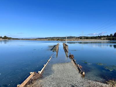

Katie Rodriguez here, thinking back to when I paid a visit to Elkhorn Slough and saw the South Marsh Loop trail bridge fully submerged during peak high tide.
That was during a King Tide event, or when the Earth, moon and sun align in such a way that it creates a gravitational pull, causing the most extreme high and low tides we’ll see in the year.
King Tides are often seen as a window into the future of climate change—showing how rising seas will impact our coastlines. But earlier this week, the National Weather Service announced that coastal zones from the North Bay (Santa Rosa, Napa, San Rafael) all the way down to Monterey County—with the exception of Santa Cruz County—would be at risk of minor coastal flooding from Tuesday night into Wednesday (today).
Just like the King Tide, this minor flooding event will impact low-lying areas along the bay at Elkhorn Slough at high tide—with a 1.08-foot inundation at 10:31pm. Translation: This is 1.08 feet above normal dry ground.
It made me wonder: How do we view these smaller coastal flood warnings in the context of climate change? The answer—like most things weather-related—is complex and very…sciencey.
“A lot of this is really connected to what’s happening right at sea surface level,” says Rick Canepa, a meteorologist with the National Weather Service’s Monterey-based San Francisco Bay Area office. “If there's more heat received in the system, there tends to be more expansion because there's more energy received...the molecules tend to expand more."
In other words, heat flows from warm to cold—when there’s a significant temperature difference between the air and the water, that exchange can dramatically influence how the air behaves, directly impacting coastal weather patterns.
Canepa suggests that these minor flooding events are signs of changing environmental conditions—driven by both large-scale forces, like oceanic heat patterns, and local factors, such as the shape of the coastline or the depth of the sea floor.
So, what dictates sea surface temperatures? Things like longitude, latitude, proximity to the equator, the amount of direct sunlight, how those variables shift with the seasons, and whether heat is being absorbed by the ocean or the atmosphere.
“What I'm talking about here is thermodynamics,” Canepa explains—“the behavior of heat exchange in a system.”
As for whether this time of year is unusual for coastal flood warnings of any kind?
“Not as likely at this time of year,” he says, “except when the sun and the moon are more in alignment (King Tides).” Summer typically brings fewer storms that affect West Coast tides, less wind interference, and “no organized low-pressure systems.”
Although this is a minor flooding event, the science suggests events like this will become more common as the planet continues to warm. There’s no danger with this particular tide—but if you're out for a late-night beach walk tonight, what do you see?


(0) comments
Welcome to the discussion.
Log In
Keep it Clean. Please avoid obscene, vulgar, lewd, racist or sexually-oriented language.
PLEASE TURN OFF YOUR CAPS LOCK.
Don't Threaten. Threats of harming another person will not be tolerated.
Be Truthful. Don't knowingly lie about anyone or anything.
Be Nice. No racism, sexism or any sort of -ism that is degrading to another person.
Be Proactive. Use the 'Report' link on each comment to let us know of abusive posts.
Share with Us. We'd love to hear eyewitness accounts, the history behind an article.