

Some 17,350 Monterey County residents remain impacted by evacuation orders and warnings as a new cold front arrives Saturday, Jan. 14, bringing with it reminders of caution and continued orders to residents not to return home until evacuation orders have lifted.
New evacuation orders were issued at 1pm on Jan. 14 for a 10-mile stretch of the Carmel River, from Rancho San Carlos Road to the northwest and Klondike Canyon Road to the southeast. The area includes neighborhoods that were evacuated due to flooding earlier in the week.
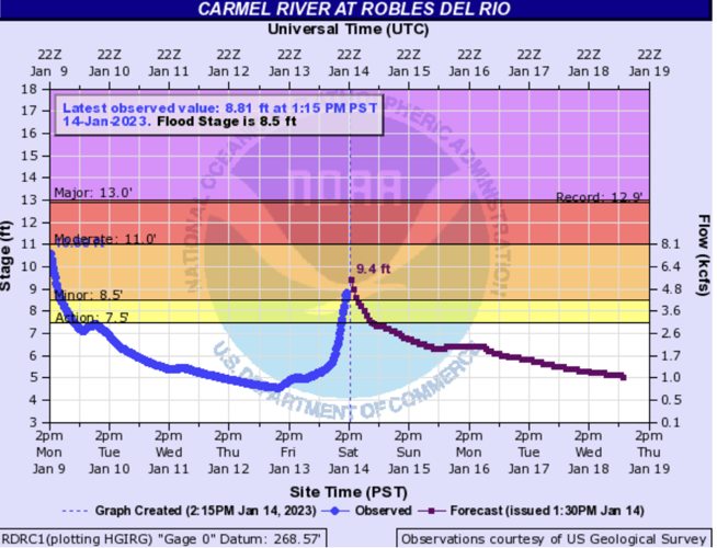
The Carmel River at Robles Del Rio exceeded flood stage of 8.5 feet, with a height of 8.8 feet recorded at 1:15pm Saturday afternoon. A hydrologic forecast from the National Weather Service shows the river reaching 9.4 feet this afternoon before going down again.

The Carmel River forecast as of 2:15pm Saturday, Jan. 14.
The community of Pajaro also remains under evacuation orders. A new evacuation warning was issued in North County for the community of Las Lomas along the Pajaro River at noon on Saturday, Jan. 14.
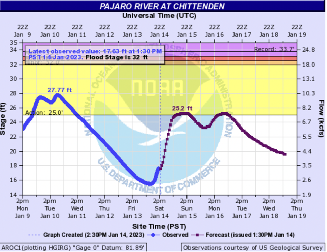
The Pajaro River has receded since Monday, but is rising again and is forecast to reach 25.2 feet Sunday afternoon. Flood stage for the Pajaro River is 32 feet, but weather officials list 25 feet as the "action stage" to be vigilant.

The hydrologic forecast for the Pajaro River, updated at 2:30pm Saturday, Jan. 14.
In addition, evacuation orders remain in effect along the Salinas River from the ocean at the northwest to Gonzales at the southeast.
Along the Salinas River in South County, evacuation orders remain in effect for San Lorenzo County Park and between King City south to San Lucas.
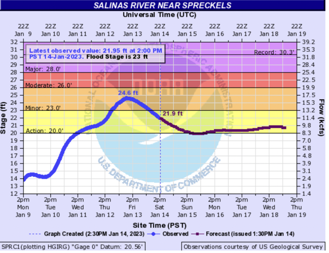
The Salinas River at Spreckels reached flood stage on Thursday night, but did not ultimately flood major roadways that could have had the effect of cutting off access to the Monterey Peninsula, creating the effect of making it into "an island." Many road closures related to flooding, slides and other debris remain in effect and officials encourage people to avoid non-essential travel and to abide by all road closure signs.
The latest hydrologic forecast shows the Salinas River at Spreckels remaining in the "action stage" at least through Wednesday, Jan. 18. The large Salinas River watershed and sandy river are unpredictable, and water can take days to flow downriver from the many tributaries that feed into it.

The forecast for the Salinas River as of 2:30pm on Saturday, Jan. 14.
Evacuation warnings remain in place throughout a geographic spread in Monterey County. Areas with warnings include Moss Landing, along the old Salinas River channel; low-lying areas along the Big Sur River; and in Salinas in the Bolsa Knolls neighborhood and the Sherwood Lake Mobile Home Park and Rancho Salinas Mobile Home Park adjacent to Carr Lake.
As of 8am Saturday morning, there were 116 people utilizing the county's shelters. Many local hotels are also offering discounted rates to evacuees.
The National Weather Service forecasts scattered rain for the next two days. "Rain finally subsides by Monday afternoon/evening," according to a forecast update at 1pm on Saturday, Jan. 14. "Isolated to scattered showers and storms possible this afternoon and evening, main risks being localized heavier downpours and a few lightning strikes."
For continued updates on evacuation areas and road closures, check the Monterey County Office of Emergency Service's storm page.


(0) comments
Welcome to the discussion.
Log In
Keep it Clean. Please avoid obscene, vulgar, lewd, racist or sexually-oriented language.
PLEASE TURN OFF YOUR CAPS LOCK.
Don't Threaten. Threats of harming another person will not be tolerated.
Be Truthful. Don't knowingly lie about anyone or anything.
Be Nice. No racism, sexism or any sort of -ism that is degrading to another person.
Be Proactive. Use the 'Report' link on each comment to let us know of abusive posts.
Share with Us. We'd love to hear eyewitness accounts, the history behind an article.