
Despite high water levels on the Salinas River that have threatened to flood Highway 68, the thoroughfare remains open as of noon on Monday, March 13—though officials have moved to close other roads around the county as a result of flood conditions caused by the past week’s storms.
There have been concerns that a flooded Highway 68 could potentially create a “Monterey Peninsula Island” cut off from Salinas, Highway 101 and much of the rest of Monterey County to the north—especially as officials have already fully closed a stretch of Highway 1 near Watsonville as a result of severe flooding on the Pajaro River. Such concerns also arose, but did not occur, during January’s flood events, when Monterey County Sheriff Tina Nieto warned of an “island” effect similar to that experienced during the 1995 floods.
By Monday morning, the Salinas River near Spreckels appeared dangerously close to levels that could cause just that, cresting at just shy of 27 feet, according to National Weather Service hydrological data. That level was roughly a foot shy of the 28-foot flood stage that would likely prompt a road closure on Highway 68, according to Shaunna Murray, senior water resources engineer with the Monterey County Water Resources Agency.
For now, the highway remains open, with Monterey County officials stressing that a westbound lane closure on the bridge passing over the river is to allow crews to monitor water levels. While the those levels are expected to retreat in the near term, there is more rain in the forecast with another atmospheric river expected to impact the region from Monday evening into Tuesday—and NWS data projects that the Salinas River near Spreckels could again rise over 27 feet by noon Friday, potentially causing more flooding.
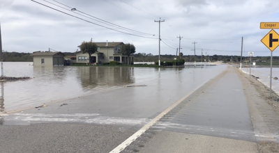
While Highway 68 remains intact, flooding has forced more road closures elsewhere around the county, including on Spreckels Boulevard just south of Highway 68. Monday morning also brought the closure of Blanco Road, from Davis Road west to Reservation Road, impacting another route between Salinas and the Monterey Peninsula.
Drivers are encouraged to check road conditions and closures before traveling. The county's interactive emergency map includes information about road status.


(0) comments
Welcome to the discussion.
Log In
Keep it Clean. Please avoid obscene, vulgar, lewd, racist or sexually-oriented language.
PLEASE TURN OFF YOUR CAPS LOCK.
Don't Threaten. Threats of harming another person will not be tolerated.
Be Truthful. Don't knowingly lie about anyone or anything.
Be Nice. No racism, sexism or any sort of -ism that is degrading to another person.
Be Proactive. Use the 'Report' link on each comment to let us know of abusive posts.
Share with Us. We'd love to hear eyewitness accounts, the history behind an article.