
Memorial Day at the Arroyo Seco Recreation Area is festive: radios blaring, kids in neon bathing suits splashing in the water, parents lounging in the sun with cold drinks. It’s a beachy spot barely 20 miles from Greenfield. Up the river a short distance, the sandy banks give way to smooth granite slabs, and teens on tubes and boogie boards splash through the rapids in the gorge.
It’s a perfectly pleasant place to kick it for a three-day weekend. But lured beyond the gorge – which even for the most intrepid visitors ends about four miles upriver at a 30-foot waterfall and a dark blue pool surrounded by sheer granite walls – a group of nine hikers and a dog set out to approach Arroyo Seco from near its headwaters.
The guiding impulse was to see the Ventana Wilderness from the perspective of the river, a life-giving artery that cuts through an otherwise inhospitable landscape of jagged mountains and dry chaparral. Twentieth-century photographer Laura Gilpin, known for capturing landscapes of the West, summed up the allure: “A river seems a magic thing. A magic, moving, living part of the very Earth itself.”
The idea was this: Start at Escondido Campground, accessible by dirt road via Fort Hunter Liggett. Then, through a combination of walking, rock-hopping and swimming – and, eventually, rappelling to descend that 30-foot waterfall – ending 11 miles downstream, back at the familiar scene of barbecues and beer and splashing children. There would be no trail, but we’d have the river to follow.
Internet research yields little about the trek, but a group of San Francisco-area nudists had documented return trips in 1995, ’97, ’99 and 2000. They noted the absence of other hikers as a motivation for the route: “With the possible exception of the Forest Service campground, we can be nude the entire trip (apart from our feet),” according to a 1997 post.
The post offers little about what to expect, other than this cautionary advice: “During the 11-mile hike there are no other ways for leaving the canyon than going back to the starting point or continuing to the end.”
That’s because the river moves through a narrow canyon some 2,000 feet deep. There is no cell service. If you get nine miles downriver to the waterfall and it’s not safe to descend – too much water, say, raging through a narrow slot of rock – there is no choice but to go back up the river.

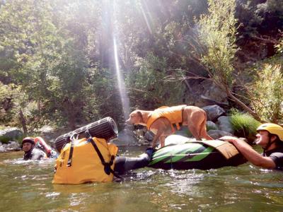
Using a tube and a sleeping pad, team members built a raft for our canine companion, Julius, and floated him down stretches of the river.
We checked in with the King City office of the Monterey Ranger District of Los Padres National Forest, where administrative clerk Lynn Olson says our plan came off as risky: “Nobody has ever asked me about that route before, ever,” she says. “Most people I talk to are just taking a day hike, they find a swimming hole and enjoy themselves.”
People do travel from Escondido Campground to the Arroyo Seco day use area, Olson says, but they tend to prefer the terrestrial options: Arroyo Seco Indians Road (mostly closed to thru-traffic since the Marble Cone Fire of 1977) or the Santa Lucia Trail.
“There is no expectation of safety in the wilderness,” Olson adds.
With that in mind, we were cautious. Over several years we consulted with regularity a U.S. Geological Survey gauge no. 11152000 so we could find a time when the flow seemed safe. At low water, it would be too rocky; too high, and it would be hazardous. Last summer, when we’d considered making this one-way descent, the flow was at a record high in 116 years of 100 cubic-feet per second, a particularly wet year. This May, it was down to 21 cfs. It was go time.
Nine of us donned wetsuits, sneakers and backpacks affixed with pool noodles as flotation devices. Accompanied by one dog – an energetic boxer-pitbull mix named Julius – we walked from Escondido Campground to the river. That would be the last stretch of trail we’d see for three days.
River miles are slow going; we averaged a half-mile per hour.
The river begins in shady forest, with clear waters trickling in from numerous tributaries. A couple of miles downriver, rock slabs start to overtake the wooded banks, and the river deepens and slows, with dozens of sandy beaches. By the waterfall, around mile 9, it narrows into sheer cliff on both banks.
We flung our packs from a ledge into the pool below, and took turns rappelling down the cliff, Julius harnessed in and in the arms of an experienced climber. About a quarter-mile below the waterfall, we encountered the first people we’d seen in three days, a group of teenage girls clambering on the rocks.
Just a few (slow) miles from civilization, we’d encountered what Gilpin promised: not just solitude, but magic.


(1) comment
Sounds like a most excellent aquatic adventure. Glad I finally unburied that two-week-old Weekly this morning.
Welcome to the discussion.
Log In
Keep it Clean. Please avoid obscene, vulgar, lewd, racist or sexually-oriented language.
PLEASE TURN OFF YOUR CAPS LOCK.
Don't Threaten. Threats of harming another person will not be tolerated.
Be Truthful. Don't knowingly lie about anyone or anything.
Be Nice. No racism, sexism or any sort of -ism that is degrading to another person.
Be Proactive. Use the 'Report' link on each comment to let us know of abusive posts.
Share with Us. We'd love to hear eyewitness accounts, the history behind an article.