
Katie Rodriguez here, asking myself an oddly familiar question: What is the difference between El Niño and La Niña, and are we experiencing one, or the other?
With winter quickly approaching—officially beginning this Saturday, Dec. 21, at approximately 1:21am (happy winter solstice to all)—we’ll soon find out if we’re entering a La Niña event. Currently, forecasts point to a weaker La Niña.
“We’re on La Niña watch, and conditions are still likely,” says Rick Canepa, a meteorologist with the National Weather Service's Bay Area office. “La Niña conditions are likely to emerge between now and January 2025.”
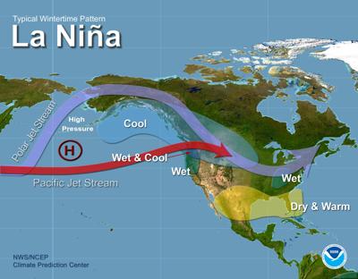
La Niña is a weather event which generally means cooler-than-average sea surface temperatures in the central and eastern equatorial Pacific Ocean; contrasting with El Niño, which is associated with higher-than-average sea surface temperatures. These temperature shifts affect atmospheric pressure, storms and rainfall patterns—and the impacts vary across California and the country.
Just how much cooler-than-average these sea surface temperatures are determines how strong, or weak, a La Niña event will be.
How and when will we know? Scientists monitor specific oceanic and atmospheric indicators, which are averaged over the last three months, to confirm whether or not we’re entering a La Niña event.
I tried to figure out what this might mean, or what we can expect, for the Central Coast in terms of weather—a question I know meteorologists and climate scientists hate to answer because forecasting, especially in the era of climate change, is increasingly challenging. As many of us are familiar with, while historical patterns offer trends, forecasts can shift, and unexpected storms can always occur.
If this year sees another La Niña event, it will mark the fourth consecutive occurrence.
“Last year was our third La Niña in a row, which is unusual,” says Keaton Browning, a lead forecaster with Surfline, a platform that provides surf reports, forecasts and live ocean conditions. “The last strong one was 2020.”
So, what might we cautiously expect, based on historical trends? Browning says that a lot of the time, La Niña means fairly dry weather south of the Bay Area and more rainfall in the North, especially in the Pacific Northwest. However, storm patterns can shift, causing La Niña systems—typically more likely to follow a path near the Aleutian Islands—to instead reach the California coastline.
I brought up the historic storms that hit Pajaro in March 2023, technically following a weaker La Niña event.
“You can always get a rogue storm,” Browning says. “All it takes is a couple weeks and it's the most memorable point in the season. You have to take the forecasts with a bit of a grain of salt.”
I asked about what this might mean for wave action. Many surfers and ocean aficionados are well acquainted with the fact that the pressure differentials associated with El Niño and La Niña events can often translate into bigger waves.
“The weaker La Niña in 2022 produced phenomenal surf,” Browning says. “Take advantage of what we have in December and early January. Things will simmer down once we get into the meat of winter.”
P.S. If you’re not an experienced ocean-goer seeking big waves, experts recommend keeping your distance while wave-watching.


(0) comments
Welcome to the discussion.
Log In
Keep it Clean. Please avoid obscene, vulgar, lewd, racist or sexually-oriented language.
PLEASE TURN OFF YOUR CAPS LOCK.
Don't Threaten. Threats of harming another person will not be tolerated.
Be Truthful. Don't knowingly lie about anyone or anything.
Be Nice. No racism, sexism or any sort of -ism that is degrading to another person.
Be Proactive. Use the 'Report' link on each comment to let us know of abusive posts.
Share with Us. We'd love to hear eyewitness accounts, the history behind an article.