

A powerful atmospheric river is coming and it's anticipated to roll right over Monterey County over Wednesday and Thursday, Jan. 4-5. County officials are urging residents to be prepared for what could be crippling conditions, including wide-spread flooding and power outages.
Rain is expected to arrive late tonight or early tomorrow, especially in the mountainous regions, with another band of rain impacting lower regions tomorrow in the late afternoon and evening, according to the National Weather Service, San Francisco Bay Area Region. Big Sur could see several inches of rain with about an inch or more of rain in valley areas and on the Monterey Peninsula.
Wind is expected to be significant. A warning will be in effect from 4am Wednesday through 10am Thursday, with gusty winds of 20-30 mph to start in the Salinas Valley, then increasing to 30-40 mph with gusts of up to 60mph. On the Monterey Peninsula there will be a similar pattern of 20-30mph to start, then increasing to 40-45 mph, with possible gusts of up to 50-60 mph over Pebble Beach and Pacific Grove.
Flooding is especially worrisome to county officials in the wake of the big storm that hit the last day of 2022, dumping several inches in some areas of Big Sur and nearly an inch in Pacific Grove over several hours. Officials imposed an evacuation order on the neighborhood of Bolsa Knolls near north Salinas after the Santa Rita Creek flooded.
The soggy ground that was left behind by that storm, combined with high winds, could lead to further flooding and downed trees across the county, making travel difficult, if not impossible in some areas, and possibly flooding homes.
County officials were concerned enough about the danger flooding from the Pajaro River poses to the Pajaro neighborhood of North County that Monterey County supervisors Luis Alejo and Chris Lopez walked the area providing Spanish-language translation to warn residents of the potential danger.
"We are that worried about Pajaro," says Maia Carroll, communications coordinator.
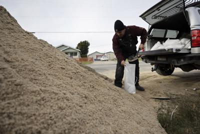
Other areas of concern include Chualar in South County and Bolsa Knolls near Salinas. The county has been providing sand and sandbags to residents in those areas. They are closely monitoring the Pajaro, Salinas and Carmel Rivers which could reach or exceed flood stage.
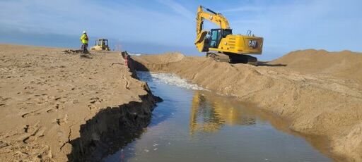
Monterey County officials dispatched workers and equipment to the Salinas River Lagoon on Tuesday, Jan. 3 to intentionally breach the Salinas River at Monterey Bay to prevent flooding upstream during an expected atmospheric river storm coming Jan. 4-5.
Today workers breached the Salinas River at the Salinas River Lagoon in the hopes of preventing flooding upstream. Flood walls are being constructed along the Carmel River at the ballfields near Paso Hondo, as well as along the Pajaro River near Murphy Crossing.
Temporary evacuation centers have been identified, with possible plans for more. So far the county is planning on two centers:
- Carmel Valley Library, 65 W. Carmel Valley Road, Carmel Valley, 831-647-7760
- Prunedale Library, 17822 Moro Road, Prunedale, 831-796-3080
The centers are scheduled to be open 8am-5pm, Wednesday through Friday.
The county's Operational Area Emergency Operations Center will be on high alert beginning Wednesday through the duration of the storm's impacts, according to a press release. In addition, emergency and road crews are preparing for 24-hour shifts and pre-staging equipment.
In the lead up to the storm county officials have been taking preemptive measures such as inspecting and cleaning culverts, conducting street sweeping after the last storm to eliminate debris that could cause drain blockages, patrolling river levees and pre-positioning tens of thousands of sandbags around the county.
Caltrans similarly has been preparing over the last few months, says Kevin Drabinski, public information officer for the Central Coast region. One focus has been on culverts, which direct water underneath roadways, instead of across them, preventing washouts.
Culverts, Drabinski says, are the "unsung heroes" when it comes to keeping roadways open. "We did a lot of work to keep those culverts open." The reports coming in are that culverts constructed at burn scars created by the Dolan Fire in 2020 are working well so far.
Residents near natural water courses such as rivers and streams are encouraged to collect sandbags and secure their homes. A list of free sandbag locations can be found at bit.ly/MontereyCountySandbags. For locations where sand is stockpiled go to bit.ly/MoCosandstockpiles.
Obey all road closure signs and do not try to drive through a flooded area.
For more information about how to prepare, go to the MCOES Storms, Floods and Landslides webpage: bit.ly/MCOESstorms.
Other advice includes signing up for Alert Monterey County to receive emergency notifications by text. Sign up at bit.ly/Alertsignups.
Residents are also advised to create an emergency kit with three days worth of supplies in case of a power outage or in the event they must leave their homes.
Consider this storm as preparation for storms that are expected to continue coming in the next couple of weeks.
"We're in for a really wet pattern going into the middle of January," says Rick Canepa, NWS meteorologist in the Monterey office. "The Pacific storm track is operating on all cylinders right now."


(0) comments
Welcome to the discussion.
Log In
Keep it Clean. Please avoid obscene, vulgar, lewd, racist or sexually-oriented language.
PLEASE TURN OFF YOUR CAPS LOCK.
Don't Threaten. Threats of harming another person will not be tolerated.
Be Truthful. Don't knowingly lie about anyone or anything.
Be Nice. No racism, sexism or any sort of -ism that is degrading to another person.
Be Proactive. Use the 'Report' link on each comment to let us know of abusive posts.
Share with Us. We'd love to hear eyewitness accounts, the history behind an article.