
Hours ahead of what's predicted to be a severe atmospheric river storm hitting Monterey County tomorrow, Wednesday, Jan. 4, Monterey County officials issued an evacuation warning for the Pajaro community in North Monterey County and preemptively closed county parks.
The city of Watsonville in Santa Cruz County, just on the other side of the Pajaro River from Monterey County, has already issued mandatory evacuation orders for neighborhoods with a high risk of flooding during the storm.
The Monterey County warning for the Pajaro area begins at 8am tomorrow morning and will continue until further notice, according to an alert sent out just before 7pm today. Specific information for which neighborhoods are affected can be found here on the Monterey County Office of Emergency Services interactive map.
County parks that will be closed beginning tomorrow include Jacks Peak, Manzanita, Royal Oaks, San Lorenzo and Toro. San Lorenzo Park will remain open for camping. Trails will be closed at lakes San Antonio and Nacimiento.
County road closure information will be updated here.
Residents are encouraged to sign up for the county's alert system at bit.ly/Alertsignups.


(2) comments
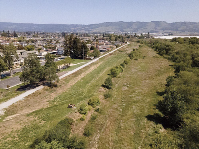
After posting my first comment, remembering reading about a project to help clear the Pajaro River to avoid flooding, I looked and found this website about that project https://www.prfma.org/risk-management. Note that it says on the ground work on the project is expected to start in 2025. It should not take much digging for reporters to find out why it is expected to take so long before work begins. I will not be surprised if the delays are due to regulatory requirements and slow moving bureaucracies. Hopefully the Pajaro community will not be washed away before the project is completed. It is interesting to compare the photo in the Weekly's story with the photo on the project's website https://www.prfma.org/risk-management. I suspect there is a story there (e.g., was that photo taken after the last floods cleared out the waterway?).
Thank you for the story. Looking at the photograph with the story, which appears to show the Pajaro River drainage so overgrown it will be unable to drain heavy storm flows sufficiently, I think the next story should be about how the Clean Water Act and other laws intended to protect water quality etc., and the bureaucracies tasked with enforcing them, act to increase the threat of floods to lives and property by blocking removal of overgrowth from waterways.
Welcome to the discussion.
Log In
Keep it Clean. Please avoid obscene, vulgar, lewd, racist or sexually-oriented language.
PLEASE TURN OFF YOUR CAPS LOCK.
Don't Threaten. Threats of harming another person will not be tolerated.
Be Truthful. Don't knowingly lie about anyone or anything.
Be Nice. No racism, sexism or any sort of -ism that is degrading to another person.
Be Proactive. Use the 'Report' link on each comment to let us know of abusive posts.
Share with Us. We'd love to hear eyewitness accounts, the history behind an article.