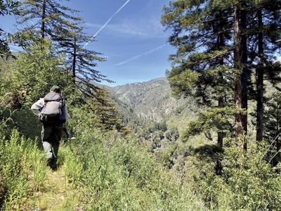

Roughly two miles into the Pine Ridge Trail, after a winding trek that steadily, and sometimes sharply, ascends through Big Sur, is a shining emblem. The emblem, erected just off the path, tells me my hike so far – navigating exposed hill faces, climbing under coastal redwood canopies and greeting views of the Pacific Ocean and mountaintops in a single panorama – was only a pregame.
“VENTANA WILDERNESS LOS PADRES NATIONAL FOREST,” the clean, wooden sign reads. Well, clean for now.
“In a few months, that sign will look like downtown Dallas,” says Rich Popchak, of nonprofit Ventana Wilderness Alliance. Popchak, who has been working to conserve Big Sur’s trails since the early 2000s, laments the graffiti and tagging he knows is synonymous with public access; however, public access has been prohibited for five years on this trail, and three days before the trail’s official April 13 reopening, the sign looks as it did when it came off the laser cutter. It draws Popchak’s admiration.
Up to this point, the trail is on Pfeiffer State Park. Passing this landmark means leaving state land and crossing into federally protected wilderness – a different game for myriad reasons, some obvious to the hiker and others not so much. A ban on mechanized tools means the 13,100 hours of manual rehab required to reopen the trail had to be done with simple tools. The Soberanes Fire of 2016 and resulting slides following 2017’s wet winter – the events that shut down the trail – did not mind these boundaries; however, in restoring the trail, a redwood that fell just before the sign could be cut up with a chainsaw. Those that fell beyond the boundary required handsaws. Crews could technically bring their supplies by a motorized vehicle until they reached the wilderness boundary. Beyond the boundary, pack mules were the preferred method of transport.
The differences go beyond regulations. Our destination was Ventana Camp, about three miles into the wilderness. This stretch of trail, more exposed than the first two miles, is hotter and flatter but requires more concentration to negotiate a narrow path that puts hikers one step off a steep slide. The flora shifts from redwood forest to chaparral.
The sign for Ventana Camp signals approach, not arrival. What remains is the trail’s most challenging section so far: a steep and winding mile-long descent down to the Big Sur River – which means a steep and winding mile-long ascent on the way back.
The Pine Ridge Trail’s most popular destination, the hot springs at Sykes Camp, are five miles beyond Ventana Camp. Prior to the trail’s closure, those hot springs drew throngs of visitors, which presented challenges of over-use. Some litter might be expected. Not as expected, Popchak says, was an effort to carry quick-drying concrete 10-plus miles to the springs to build hot tubs. (U.S. Forest Service officials are adamant that now, after reopening, such tubs will be prohibited, and any attempted builds will be torn out.)
Popchak acknowledges a tension between preservation and access when it comes to the popularity of wilderness areas. “I fall on the side that wilderness protection is the least we can do to show future generations what the world looked like before Europeans came to North America and trashed the place,” he says.
The Ventana Wilderness Alliance sees the reopening of the trail as a chance to address this delicate balance.
At the trailhead, hikers are now asked to complete a self-issued permit for their trip. They provide basic information such as name, date and length of their excursion, group size, and whether they have animals. It will allow VWA and its partners to collect empirical data on how many people are using the trail over time. The data will be critical if the organization pursues what Mike Splain, executive director of VWA, calls the “nuclear option” – a quota-based permit system for the trail.
“You don’t want to do this but when you have a trail accessible by a state highway, the only way to guarantee a positive experience for everyone is to limit use,” Splain says.


(1) comment
Most national parks are next to state highways & parking is properly managed in most cases.
Welcome to the discussion.
Log In
Keep it Clean. Please avoid obscene, vulgar, lewd, racist or sexually-oriented language.
PLEASE TURN OFF YOUR CAPS LOCK.
Don't Threaten. Threats of harming another person will not be tolerated.
Be Truthful. Don't knowingly lie about anyone or anything.
Be Nice. No racism, sexism or any sort of -ism that is degrading to another person.
Be Proactive. Use the 'Report' link on each comment to let us know of abusive posts.
Share with Us. We'd love to hear eyewitness accounts, the history behind an article.