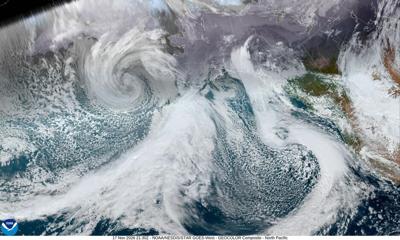

More wet and cold storm systems are on the way, starting later tonight, Tuesday, Nov. 17, when rain is expected, with possible thunderstorms Wednesday and Thursday, according to the National Weather Service.
On Thursday, Salinas and the Salinas Valley will see more possible showers and a thunderstorm before 10am, then more rain with wind gusts of up to 38mph. The skies clear up on Friday, with rain returning Saturday evening.
The forecast for inland Monterey County on Wednesday is for rain and a possible thunderstorm and a high near 58 degrees. Winds are expected to be between 17 and 22 miles per hour with gusts up to 34mph. Rainfall amounts are expected between three quarters of an inch and an inch.
For the coastal region, winds Tuesday night are forecasted for between eight to 18 miles per hour with gusts of up to 25 miles per hour. The weather service has issued a wind advisory along the coast from 9pm, Tuesday through 1pm Wednesday.
A beach hazards statement is also in effect through at least 4pm Wednesday, with an increased risk for sneaker waves and strong rip currents that include breaking waves of 13 to 17 feet.


(0) comments
Welcome to the discussion.
Log In
Keep it Clean. Please avoid obscene, vulgar, lewd, racist or sexually-oriented language.
PLEASE TURN OFF YOUR CAPS LOCK.
Don't Threaten. Threats of harming another person will not be tolerated.
Be Truthful. Don't knowingly lie about anyone or anything.
Be Nice. No racism, sexism or any sort of -ism that is degrading to another person.
Be Proactive. Use the 'Report' link on each comment to let us know of abusive posts.
Share with Us. We'd love to hear eyewitness accounts, the history behind an article.