
For just a moment, after three years of a closed Highway 1, Big Sur was almost getting back into the swing of a normal summer.
On one mid-summer Sunday in 2026, the lawn behind Big Sur River Inn restaurant saw its typical crowd of people. One group, visiting from Spain, noted that because the highway was finally open, they could do their long-awaited circuit traveling from Los Angeles to San Francisco, then down the Eastern Sierras. Another couple, from Orange County, were visiting the area for the first time, drawn to Big Sur for the sprawling vistas and unadulterated natural landscape.
Group after group shared a similar story. The highway reopened, they had seen photos of the redwoods, of Bixby Bridge and other magical places like Keyhole Arch at Pfeiffer Beach, and booked their respective trips.

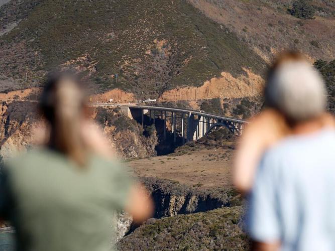
Hurricane Point, looking towards Bixby Bridge on Highway 1.
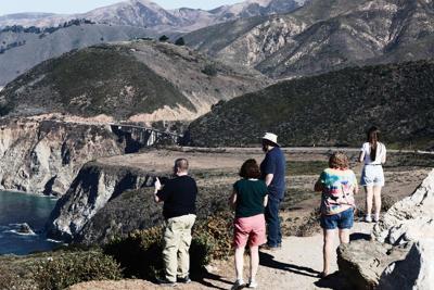
But on this particular day, Aug. 9, a confluence of events converged to reshape these visitors’ plans, some of whom were already shifting their expectations for their trips. For many hoping to make Bixby Bridge one of their stops along the highway, they were met by a string of orange traffic cones and two highway patrol officers blocking any pursuit of selfies.
At the same time, a mix of helicopters, water tankers, and other aircraft were flying overhead in increasing numbers as the sky became tinged with a muted, burnt orange haze. The sounds of soft jazz on the lawn soon became intertwined with sounds of a CH-47 Chinook, a helicopter that weighs as much as nearly eight Southern elephant seals, or 14 Honda CR-Vs, with the ability to carry up to 3,000 gallons of water or fire retardant.
“This place seems like it’s got the best of all worlds,” says Alex Hernandez, visiting from Las Vegas with his family for the first time. “One thing that caught my attention was the bridge. All it takes is literally one click of something and then it becomes part of your algorithm on social media, and then you get flooded with ideas like this.”
What he and many other travelers didn’t know was that traffic at Bixby Bridge had sparked so much community uproar that a parking moratorium was approved in May by the County Board of Supervisors. As a result, no-parking signs were installed on Aug. 5, four days prior.
Nor could travelers have predicted that Sunday would mark the beginning of the Timber Fire, which would threaten nearby homes and landmarks like the Henry Miller Library before burning more than 500 acres within Pfeiffer Big Sur State Park, home to the region’s most popular campground. The Timber Fire would become the fourth-largest fire this year in California, behind the Plaskett Fire, which would begin just three weeks later.
“[My cabin] was the second closest structure to the Timber Fire when it started,” says Mike Freed, owner of Post Ranch Inn. “It’s a miracle that it was saved, but it’s because I had friends who were up there who saved it.”
What is normal in Big Sur is changing – growing tourism is colliding with the economic and housing pressures felt along much of the California coastline, all of which is amplified by an uniquely rugged environment increasingly in the crosshairs of a changing climate.
How to respond to these competing pressures is an urgent question for the future of Big Sur and its people.
“Tourism needs to be managed, otherwise you’re destroying a community and you’re destroying the environment,” says Rob O’Keefe, CEO of the regional visitors bureau See Monterey. “How do you navigate that in a way that’s responsible to the very nature that people want, and to the residents who live within?”
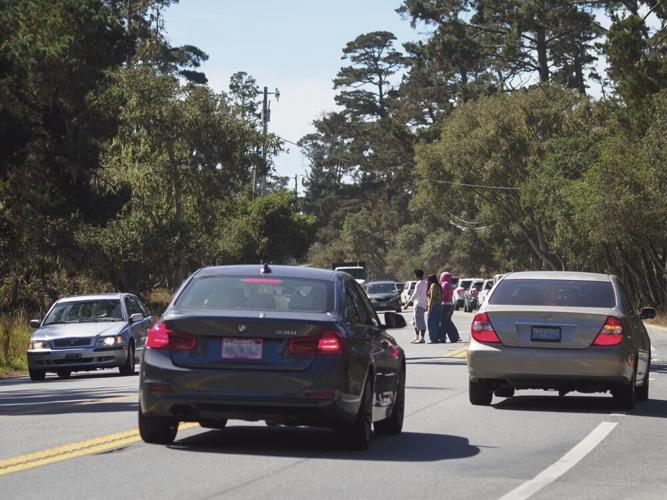
THE RISE OF SOCIAL MEDIA is what many locals point to as the main driver of the surge of visitors, becoming the impetus for the pit-stops at the bridge and backlog at Point Lobos State Natural Reserve. The ability to geotag locations posed incipient trouble for Big Sur as traffic chokepoints worsened, sometimes leading to hours-long delays and complicating emergency response efforts in the area.

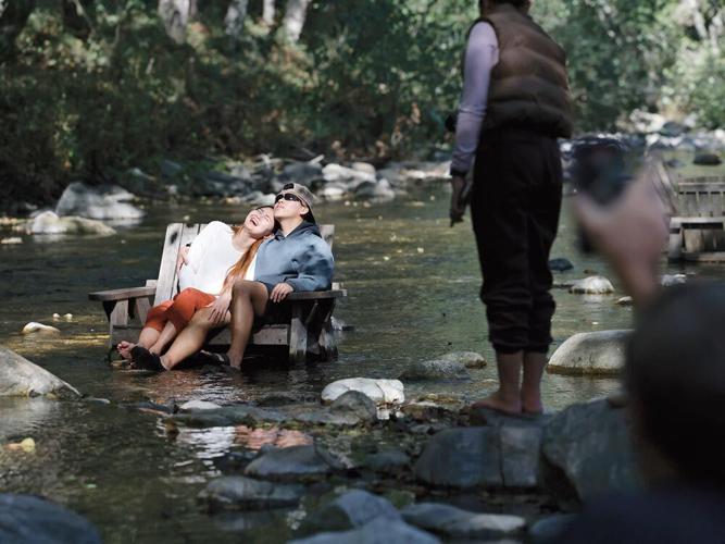
Tourists sunbathe in the Big Sur river, behind the Big Sur River Inn, a popular destination for visitors to listen to music, get lunch, and stay for the night at the lodge.
According to a report by Pew Research Center, social media use by U.S. adults went from just 26 percent in 2008 to 72 percent in 2021. In recent years, that percentage has grown but split depending on age and platform. For example, another Pew report found that 80 percent of U.S. adults ages 18-29 used Instagram in 2025, compared with 62 percent of adults ages 30-49, 40 percent of those ages 50-64, and 19 percent of those 65 and older. (YouTube maintains the highest usage rates across all age groups, while Instagram trails Facebook slightly in overall usage.)
Though difficult to capture the actual volume of people that descend on Big Sur, there are proxies. On Instagram, 1.9 million posts have the #bigsur attached, and it has appeared frequently among the top 20 most Instagrammed places in the U.S and among the top 10 in California. The Community Association of Big Sur installed a traffic counter along Highway 1 near Malpaso Creek just south of Carmel Highlands and, in 2025, began publishing data monthly. Between February and July of this year, traffic in the area (and following the reopening of the highway) nearly doubled from 131,655 vehicles to 245,760 vehicles.
Many locals say social media not only puts places on the map that visitors might not otherwise find, but it also shapes how people travel.
“People go traveling for a different purpose,” says Dana Carnazzo, who is on the board of the Henry Miller Library and has lived near Bixby Bridge a majority of her life. “Before, people wandered down the coast and puttered around; there was no one to give them information about what was where. Once everything was on Instagram, it became more like a theme park.”
Tourism in Big Sur is an economic lifeline just as much as it is a danger to the community. Monterey County collects a 10.5-percent transient occupancy tax on lodging in unincorporated areas, including Big Sur. (If approved by votes on Nov. 3, Measure E would increase this rate to 12.5 percent.)
VISITORS GENERATE MORE THAN $3 BILLION annually for the county, according to a 2025 study by See Monterey, supporting 27,596 jobs in hospitality, with accommodations spending surpassing $1 billion for the first time. In terms of tax revenue, $199 million was collected for local governments, out of a total of $346 million split with the state. Despite international travel remaining lower than usual, their study still found record-breaking gains.
But the same rugged terrain that draws visitors (and visitor spending) to Big Sur also poses a challenge: Its protected status limits housing development of the community that sustains tourism, while the mountainous topography leaves the region vulnerable to disasters.
“These two fires are a great example. Both of them, by all indications, are human caused,” says Martha Diehl, a Monterey County planning commissioner and Big Sur resident. “Human caused: related to the increase of visitor traffic, related to the pressures pushing the visitors ever further out to get the values that they value, and the lack of resources to manage that visitation,” she says.
MANY PEOPLE INTERVIEWED FOR THIS STORY who moved to the region decades ago remember their first encounters with a rugged Big Sur, infused with artists, artisans and people who were finding creative ways to live off-grid in the folds of the coastal mountains.
Life was solitary then, and in many ways, still is. “A community of hermits” is how Carnazzo describes it. With the exception of a stint in her 20s sailing and working at sea, Carnazzo has spent most of her life living in the area of Bixby Bridge. She describes her upbringing to be a wonderful, “sort of feral” childhood, drinking powdered milk, playing around outside and finding secret places in the woods.

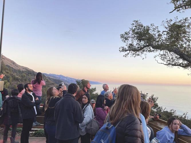
Tourism is an economic lifeline in Big Sur just as much as a danger to the community. Many locals cite the rise in use of social media as a main influence of not just where people travel, but how. People regularly gather on the back patio of Nepenthe at sunset (shown above).
“I’ve got some great stories about hanging out with Jack Kerouac early in the morning when he was writing the book Big Sur,” she says. “I had a donkey named Alf, a scruffy little donkey that I rode around everywhere, and Jack thought my donkey looked like a sacred Buddhist spirit animal, and so he put him in his book as Alf the Sacred Burro.”
The burro, in Kerouac’s book, was symbolic – intended as a representation of the remoteness and spirituality found in the Big Sur wilderness.
That wilderness and scenic splendor has long been considered something special, fragile and worthy of being protected and maintained. The creation of the highway, completed on June 27, 1937 at a cost of approximately $8 million, ushered in a whole new era of change, which was not wholly accepted even then.
The Big Sur Land Use Plan, drafted and adopted by the County in 1986 and widely regarded as the community’s most important safeguard, states that “many of the original settlers were enraged by the devastation resulting from the highway construction.” Carnazzo adds her father left in the 1970s, feeling Big Sur was too crowded. (He eventually returned.)
Former congressman and Big Sur advocate Sam Farr says his father, Fred Farr, who was an attorney and state senator representing the Central Coast from 1955 to 1966, worried that commercial signs and development would obstruct views along the highway. Eventually, those concerns led to the development of California’s scenic highway program.
The legally binding land use plan, certified by the California Coastal Commission, baked in an enduring framework for managing development, preventing coastal sprawl and protecting Big Sur’s character. Now, undergoing revisions, it remains central to decisions about the region’s future.
The plan limits subdivisions and ties development to the capacity of Highway 1, prioritizing much of the highway’s capacity for the traveling public, and focusing on viewshed protection as an integral component of future plans.
“It’s not that the viewshed is important; it’s that the viewshed is sacrosanct,” Diehl says. “Viewshed means anything you can see from Highway 1 and other designated public viewing areas for any length of time at any distance at any speed.”
The updates to the land use plan have been plagued with disagreement, beginning back in 2003. The tension typically laid in the pressure to open up the area to more housing, the redefining of what constitutes a “visitor-serving unit” and what these changes might mean for the viewshed.
Diehl notes the updates are still underway with no set completion date; the draft still needs to go back to public review, likely through more workshops, then eventually to the Planning Commission and the Board of Supervisors for approval. The current effort, she adds, is intended to clarify definitions within the plan without recommending any change to its overall direction, with the goal to make as few changes as possible.

Traffic congestion along the Carmel–Big Sur corridor has grown over the years, creating mounting safety concerns. In response to these concerns, the Monterey County Planning Commission advanced plans for the ParkIT! shuttle, a community initiative long in the making.
“The County’s primary land use planning objective is to minimize development of the Big Sur coast in order to preserve the coast as a scenic rural area where residents’ individual lifestyles can flourish, traditional ranching uses can continue, and the public can come to enjoy nature and find refuge from the pace of urban life,” the document states.
Today, as in many communities across California and the country, Big Sur faces the challenge of supporting the people who sustain its tourism economy. Yet, as visitor numbers have grown, many longtime residents say the local community has shrunk.
“We’re losing younger generations and people with children at a great rate because they can’t afford to be there,” Diehl says. “And working people who want to work in Big Sur, by and large, can’t live in Big Sur.”
CONNIE MCCOY remembers when her car broke down at Lucia in the early 1970s. She fell in love with the south side of Big Sur, describing areas around Gorda as “funky,” a place where people grew cannabis, sold jade jewelry and lived unconventionally.
She linked up with the Harlan family who ran the Lucia Lodge, managing it briefly before taking a series of caretaking jobs in the area. Such jobs, she notes, were once more common in Big Sur. Wealthier owners who lived elsewhere often provided housing for local workers at a discounted rate or in exchange for looking after their properties.
“Now, there’s more wealthy people, more showplace homes, and not full-time residents,” McCoy says. “And they hire property managers.”
Roughly two-thirds of existing residences are without permanent residents, existing as vacation homes, according to Diehl. Housing has also become increasingly expensive, with at least two homes in the area selling for more than $30 million in the past year, and an increasing number of “legacy homes” have been hitting the market.
And in this shift, many properties no longer provide the caretaker housing that once helped local workers live in the area.
The demographic shifts have affected Big Sur’s north and south differently, with the southern region seeing a greater loss of families. If it’s not housing affordability, locals report that repeated disasters have pushed people out.
McCoy, 75, considers herself one of the lifers, planning to stay in the area and live among the steep landscape as long as her body will allow. She describes her life now as remote, supported by a close-knit community. She estimates around 38 people live in the area, some part time, many of whom are older. She and her neighbors have adapted their routines to their specific isolation and road closures. After Paul’s and Regent’s slides, which closed sections of the highway for three years until a full reopening in January, she shifted her medical appointments and supply runs to Cambria and Morro Bay.
Rhea Withrow, who has lived on the south side of Big Sur for the last decade, recalls that Pacific Valley Center School, a K-12 school near Sand Dollar Beach, had about five kids total at the school when her kids attended. Her husband, who grew up in the area and went to the same school, remembers going to school with at least 50 other students.
Housing availability affects community life, and with fewer permanent residents that means fewer people to support the community. “Outside property management isn’t going to sit on a school board,” Diehl says. And new construction of housing, she adds, isn’t going to solve the problem. Instead she sees an opportunity to encourage those with existing homes to re-incorporate caretaker housing, ADUs or other ways to serve the community.
Housing needs are infinite, “Big Sur can’t build its way out of the housing problem,” Diehl says. Even without protective zoning in place, the very nature of the region – the steep slopes and protected species – makes creating new development incredibly limited.
But as Big Sur grapples with how many people it can accommodate, the stakes extend beyond housing and traffic, one that becomes especially clear when disaster strikes.
ON MONDAY, SEPT. 28, the back patio of the Big Sur River Inn is packed again. This time, it’s not tourists but local and state officials, gathered for a meeting of the Big Sur Multi-Agency Advisory Committee (BSMAAC). The aim is to bring everyone together to discuss lessons learned from the summer’s two fires and where to go from here as forecasts of a very strong El Niño were shaping up.

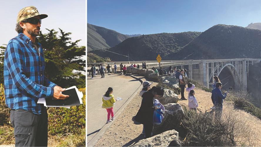
(left) Marcus Foster, founder of the nonprofit Keep Big Sur Wild, holds a copy of the Big Sur Land Use Plan at a public field trip in August to Garrapata State Park to discuss a potential bathroom project. Foster advocates for the plan and protection of the natural landscape. (right) Bixby Bridge has become one of Big Sur’s most popular attractions, but it was never intended to be. Citing safety concerns, a 12-month no-parking restriction was enacted in June of this year.
“I think we all know how the Timber Fire started,” U.S. Rep. Jimmy Panetta, D-Carmel Valley, said at the meeting. “A minor, by himself at a campfire. It got out of hand.”
Locals, including McCoy, who has patrolled the area in recent years to warn visitors of high fire risk, point to a rise in illegal campfires. Big Sur Fire Chief Matt Harris said visitation at the Timber Top campground, where the fire began, had reached unprecedented levels.
Marcus Foster, founder of the nonprofit Keep Big Sur Wild, first noticed the trend in 2018 and 2019, when he was captain of the nonprofit Big Sur Fire brigade.
“We have 10 times the visitation we had 50 years ago, and there’s literally like half of the staff,” he says, attributing the shortfall broadly to reduced federal resources. “It’s not like this is something new, but it’s just a mixture of a free-for-all, especially at night, and no law enforcement patrolling the highway, the ridges or anything in the backcountry.”
Through Keep Big Sur Wild, Foster advocates for the Big Sur Land Use Plan, in particular, arguing for responsible tourism and reiterating “physical access should not come at the expense of the landscape itself.” While the community is known for its self-reliance, acknowledging road closures and fires are part of the way of life in Big Sur, they argue tourism’s negative impacts are preventable – and that local government has a role to play.
Kate Daniels is the Monterey County supervisor representing District 5, a sprawling region that includes the entire Big Sur coast. She has pushed to protect the viewshed and manage the growing wave of visitors. Along with Diehl and Planning Commissioner Jessica Hartzell, she moved forward on solutions after residents and local businesses raised concerns about safety and workers’ ability to commute from Monterey to Big Sur.
Getting the California Coastal Commission to support the parking moratorium was a main point of friction; the agency responded with a letter recommending alternatives.
“We were like, ‘This is a non-starter, and this isn’t going to solve the problem before summer starts,’” Daniels says. She adds a challenge has been getting the agency to see that tourism-related problems pose safety risks, and proposed solutions do not reflect a general opposition to tourism.
“I don’t believe the Big Sur Land Use Plan says the only function of this highway is to serve the visiting public at all costs. It’s a priority, 100 percent. But the capacity of the highway is the measure for what development we allow it, and it feels like some of the agencies that should know this really disregard these key tenets.”
Similar tensions have surrounded the ParkIT! shuttle plans, which aim to address mounting traffic and safety concerns near the entry to Point Lobos State Natural Reserve along the Carmel/Big Sur corridor. At an Oct. 14 planning commission meeting, Coastal Commission representatives again raised concerns about public access, but commissioners unanimously voted to advance the plan, nearly eight years in the making.
Working with State Sen. John Laird, local officials secured $618,000 for traffic enforcement at Bixby Bridge while a long-term solution is developed, and another $150,000 to pay for consultants to continue planning the Point Lobos shuttle.
With El Niño ahead, residents are preparing for potentially volatile conditions, as Chief Harris urged at the BSMAAC meeting. But a broader message emerged as locals, fire staff and representatives from the U.S. Forest Service, Caltrans and other agencies spoke: addressing Big Sur’s challenges requires coordination across all levels of government, informed by local knowledge.
“I think we can plan effective management tools for land and people,” Farr says, “if the bureaucracies will listen.”
(0) comments
Welcome to the discussion.
Log In
Keep it Clean. Please avoid obscene, vulgar, lewd, racist or sexually-oriented language.
PLEASE TURN OFF YOUR CAPS LOCK.
Don't Threaten. Threats of harming another person will not be tolerated.
Be Truthful. Don't knowingly lie about anyone or anything.
Be Nice. No racism, sexism or any sort of -ism that is degrading to another person.
Be Proactive. Use the 'Report' link on each comment to let us know of abusive posts.
Share with Us. We'd love to hear eyewitness accounts, the history behind an article.