


The Monterey County Sheriff’s Office issued new evacuation orders on Wednesday, Jan. 11, for communities located along the Salinas River near Monterey Bay—with Sheriff Tina Nieto warning that the Monterey Peninsula “may become an island” amid continuing storms that are expected to cause more flooding in the coming days.
The Sheriff’s Office upgraded evacuation warnings into evacuation orders for communities straddling the Salinas River between Highway 68 and the lagoon that forms the river’s mouth, south of Moss Landing, into Monterey Bay. Speaking at a press conference at the Sheriff’s Office headquarters in Salinas on Wednesday evening, Nieto said the flooding would be “a slow-moving event” but would likely commence beginning around noon Thursday, Jan. 12, and extend into Friday “if the predictions are accurate.”
“We have concerns that the waters on the Salinas River are continuing to rise, and with the continued rise we do anticipate there could be possible flooding,” Nieto said—noting that weeks of rainstorms had left the ground “completely saturated” and prone to more flooding.
The sheriff warned that the Monterey Peninsula area could experience a repeat of conditions last seen in 1995, when flooding effectively turned the Monterey Peninsula into an “island” separated from the rest of the county.
“We anticipate that we’re going to go into a similar situation, but not as bad,” Nieto said. “Some of the roadways are going to be closed, and you could be stuck on one side or the other.”
She noted that flooding would likely “travel from south to north as the river rises,” as the Salinas River flows from the south—through the Salinas Valley—to communities in the north, such as Spreckels, before emptying into the bay.
Major roadways affected could include State Highway 68, River Road, Reservation Road and Blanco Road, and potentially Highway 1. Communities likely impacted by the flooding include Chualar and Spreckels, which “may be cut off from essential services,” Nieto added.
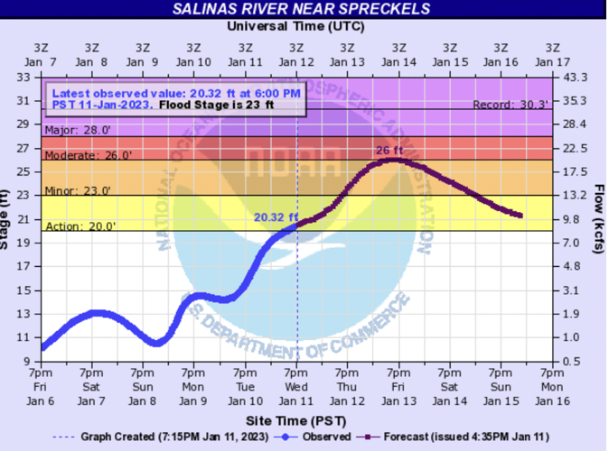
The Salinas River is now in what weather officials refer to as “flood monitoring stage,” and predictive models from the National Weather Service and Monterey County Water Resources Agency show the river will likely reach flood stage around 3pm Thursday, Jan. 12. Based on those same models, local officials are preparing for flood stage to continue until 9pm on Sunday, Jan. 15.

A hydrologic prediction model shows the Salinas River near Spreckels reaching flood stage—shown in orange on this chart—on Thursday afternoon, Jan. 12. It is already in the monitoring stage (the yellow bar) and flood stage is 23 feet. It is predicted to at 26 feet on Friday, Jan. 13.
In a statement from the Monterey County Administrative Office, county officials said they expect bridges in the impacted areas to survive the flooding, noting that they were designed to withstand such events, but added that all drivers must obey road closure signs to avoid potential drowning risk.
“Residents both on the Peninsula and in the Salinas area should expect to be cut off for two to three days,” according to the office's statement.

At 5pm on Wednesday, Jan. 11, Monterey County officials issued evacuation orders for all areas along the Salinas River from Highway 68 north to the ocean.
Nieto said that prior to briefing the public, she had spoken to Monterey County mayors and the Board of Supervisors to inform them of the situation. Authorities would begin moving to inform the public on Wednesday evening, she said, with residents in the affected areas set to receive reverse 911 calls from the county’s communications center informing them of the evacuation orders. Law enforcement officers would also be canvassing door-to-door “to let residents know we’re getting everybody out that we can.”
The sheriff said that even after flood conditions recede, evacuation orders may persist for “a few days longer” as authorities would need to “ensure that it’s safe for [residents] to go back in the area” and “check the roads to make sure they are passable.”
With potential road closures, some businesses have already announced closures on Thursday to avoid employees getting stranded away from home; school districts are considering closures as well.
In a statement, State Sen. John Laird, D-Santa Cruz, echoed Nieto's message: “If Peninsula residents and Salinas residents are cut off from essential services we are here to assist with County response efforts. We urge all Monterey County residents to heed the warnings of county officials and follow all evacuation orders along the Salinas River.”
In one piece of good news, Nieto also announced that evacuation orders had been downgraded to evacuation warnings for communities along the Carmel River, from the Carmel River Lagoon to Rancho San Carlos Road in Carmel Valley.
To see the latest evacuation maps and view county updates, click here.
To sign up for county emergency alerts, click here.
To read the Weekly’s ongoing coverage of this series of winter storms and related impacts, click here.


(0) comments
Welcome to the discussion.
Log In
Keep it Clean. Please avoid obscene, vulgar, lewd, racist or sexually-oriented language.
PLEASE TURN OFF YOUR CAPS LOCK.
Don't Threaten. Threats of harming another person will not be tolerated.
Be Truthful. Don't knowingly lie about anyone or anything.
Be Nice. No racism, sexism or any sort of -ism that is degrading to another person.
Be Proactive. Use the 'Report' link on each comment to let us know of abusive posts.
Share with Us. We'd love to hear eyewitness accounts, the history behind an article.