
It’s been a year of new wildfire maps from Cal Fire. On July 15, the state organization released yet another tool—this time focusing on how wildfires have impacted vegetation across California.
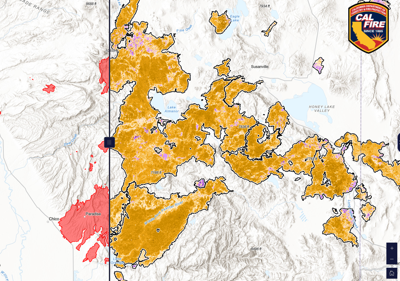
The new California Vegetation Burn Severity Online Viewer, launched by Cal Fire’s Fire and Resource Assessment Program, is an interactive public mapping tool that allows users to see where and how wildfires have impacted vegetation. It visualizes burn severity data for wildfires larger than 1,000 acres that occurred between 2015 and 2023.
The tool, now in Phase 1, was released as part of Senate Bill 1101, which requires transparency in the state’s wildfire resilience efforts. Phase 2 will provide downloadable datasets as Cal Fire refines its methods, particularly for non-forested landscapes.
“This tool helps Californians see and understand how fire affects our landscapes,” said Chris Keithley, assistant deputy director for FRAP. “It gives communities data to support efforts to plan prescribed burns, guide restoration work, and reduce future wildfire risk.”
A slider tool on the map allows the public to toggle between large wildfires from a given year and the changes in vegetation from that wildfire. Users can search fires by name, year, cause or size and view a variety of data including fire perimeters and severity classifications. The viewer, which will be updated annually to include new fires over 1,000 acres, is intended to empower landowners, planners, scientists and the public to better understand postfire conditions, and plan for future fire resilience.
Among the benefits: the tool helps identify areas in need of reforestation and restoration, assists prescribed fire practitioners in planning treatments based on how severe the burn from the previous wildfire was and how it changed the vegetation, and provides information to help understand how previous burns may influence future fire behavior.
It can also support conservation efforts by identifying changes to wildlife habitat, informing habitat management.
“Past fire severity influences the vegetation type and quantity,” said Emily Weinzheimer, Duty PIO, in a written response to the Weekly. “In turn, that influences fire behavior. In the hands of knowledgeable practitioners, this information can inform fire suppression tactics, such as where to place control lines or conduct backburns.”
Backburns are a firefighting strategy in which fire is intentionally set along a control line to consume fuel in the path of a wildfire. By reducing available fuel (or dry debris), backburning can help contain a fire and prevent its spread.
The burn-severity data was developed using advanced remote sensing techniques and satellite imagery collected one year after each fire, allowing scientists to account for vegetation recovery and tree mortality. The tool was developed by experts from the California Wildfire & Forest Resilience Task Force – Science Advisory Panel, California Air Resources Board, NASA, US Geological Survey and USDA Forest Service.
The viewer is live and available to the public here.


(0) comments
Welcome to the discussion.
Log In
Keep it Clean. Please avoid obscene, vulgar, lewd, racist or sexually-oriented language.
PLEASE TURN OFF YOUR CAPS LOCK.
Don't Threaten. Threats of harming another person will not be tolerated.
Be Truthful. Don't knowingly lie about anyone or anything.
Be Nice. No racism, sexism or any sort of -ism that is degrading to another person.
Be Proactive. Use the 'Report' link on each comment to let us know of abusive posts.
Share with Us. We'd love to hear eyewitness accounts, the history behind an article.