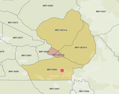

The Piney Fire in Carmel Valley grew to 221 acres overnight, with 15 percent containment, Cal Fire reports.
Forward progress was reportedly stopped around 2:30am, with evacuation orders and warnings remaining in place throughout the night. According to the County of Monterey’s evacuation map, areas around Carmel Valley Road and Martin Road are still under evacuation notices.
The fire, which had the potential to grow to 500 acres, rapidly expanded from 20 to 75 acres in just 45 minutes on Tuesday, Oct. 8. This prompted the deployment of additional resources and aircraft to help control the blaze as it burned through thick brush in steep terrain.
The source of the fire is still under investigation. A temporary evacuation point has been set up at the Carmel Valley Library on 65 W. Carmel Valley Road for all affected residents.
PG&E shut off power in select areas starting at 3pm on Oct. 8. Power is still shut off to about 229 customers, PG&E reports.
Locals can stay updated at Alert Monterey County on the County of Monterey’s website.


(0) comments
Welcome to the discussion.
Log In
Keep it Clean. Please avoid obscene, vulgar, lewd, racist or sexually-oriented language.
PLEASE TURN OFF YOUR CAPS LOCK.
Don't Threaten. Threats of harming another person will not be tolerated.
Be Truthful. Don't knowingly lie about anyone or anything.
Be Nice. No racism, sexism or any sort of -ism that is degrading to another person.
Be Proactive. Use the 'Report' link on each comment to let us know of abusive posts.
Share with Us. We'd love to hear eyewitness accounts, the history behind an article.