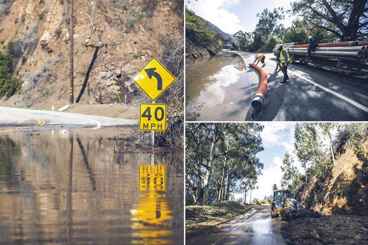


Crews work on Friday, Jan. 29 to remove mud and debris along Highway 1, south of Rat Creek, after a storm. A 150-foot stretch of the highway that crosses Rat Creek washed out and collapsed into the Pacific Ocean.
That the rugged, shape-shifting edge of North America is in motion is not surprising. What is more remarkable is that humans, beginning in 1919, constructed a scenic road along the edge of Big Sur, now conveying some 4.6 million vehicles per year.
Even officials with Caltrans, the state agency responsible for maintaining Highway 1, see it that way. The day after a 150-foot chunk of asphalt and the earth below it crumbled into the Pacific Ocean at Rat Creek in Big Sur, spokesperson Jim Shivers sounds almost unmoved by the collapse.
“Generally speaking, the Big Sur Coast is always in a state of evolution, even without rain,” he says, adding: “We’ve been through this before. We know when we get heavy rain, things can happen along the Big Sur coast.”
What happened was that as rain fell on the Santa Lucia mountain range from Jan. 27-28, material like mud and tree limbs and rocks was gathered up with fast-moving runoff. Particularly vulnerable are burn scars, where wildfires leave soil exposed and liable to wash away in a debris flow. And as debris from the Dolan Fire burn scar moved downhill at Rat Creek, it was too much even for the 66-inch drain, forcing that material and rainwater over the top of the asphalt. On the evening of Jan. 28, after the outer edge of the highway gave way, Caltrans entered into a $5 million emergency contract with Papich Construction, and a team was out at sunrise the next morning to assess the damage.
By then, the entire road was gone.
As of Feb. 2, the plan for repairs – and with it, a timeline and a budget – remains unknown.

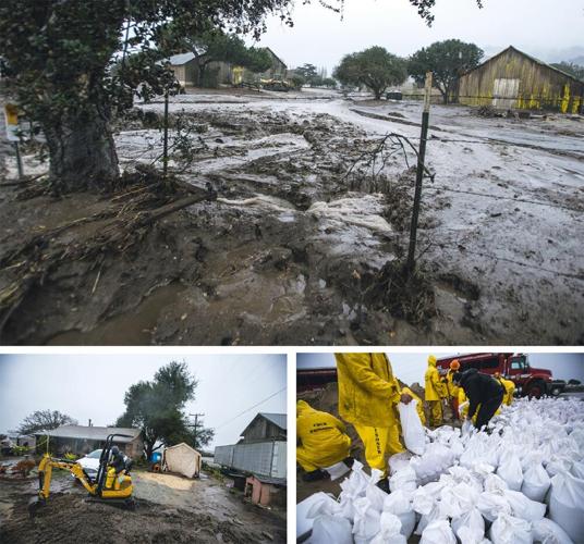
Flooding in Salinas on Wednesday, Jan. 27 left property damaged along River Road. Residents, some with the help of inmates from Cal Fire’s Gabilan Conservation Crew, packed bags with sand and created ditches to mitigate flooding in residential areas.
While the damage to Highway 1 looks dramatic, and thanks to drone footage has gotten extensive media attention from beyond the region, for Big Sur residents and business owners it’s nothing new. If anything, it’s less bad than some of the other disasters the community has endured in recent years, says Kirk Gafill, president of the Big Sur Chamber of Commerce and owner of the restaurant Nepenthe.
Gafill compares this to the slides and road closures of 2017, resulting in “Big Sur island,” leaving the rugged coast’s biggest population and commercial center cut off from services. “If that was Goliath, this is more like an angry dog,” Gafill says. “We’ve been through a lot worse.”
Because the closure is on the more remote South Coast, roughly two miles south of the Esalen Institute, most Big Sur businesses are accessible to visitors. Nepenthe reopened for outdoor dining on Jan. 25, the first day health officials allowed it, and on nice days it’s been busy since then. Gafill estimates that a closure to the south reduces traffic to businesses in his neighborhood by roughly 30 percent. But comparatively, that seems like a relatively small burden on businesses.
“It’s certainly a challenge when you have significant impacts in proximity,” he says. “Just when you feel like you got a little breathing room – 2018 and 2019 gave us a couple years to recover from 2017 – then in 2020, we get Covid and the Dolan Fire.” (The Dolan Fire, he says, had an outsized impact, coming right in the middle of peak summer season, unlike the Rat Creek washout during slower winter months.)
For some destinations, like Lucia Lodge and Sand Dollar Beach, the Rat Creek closure has cut off access entirely. And access to the South Coast of Big Sur is also temporarily cut off from the east – Nacimiento-Fergusson Road, a county road, that connects South County to the coast, was out of commission, also thanks to the storm.
County Public Works brought in a CAT 950 front end loader and other heavy equipment normally used in rock quarries to clear boulders and other debris off the road, and by Monday night, Feb. 1, was able to clear one-lane access. (Nacimiento-Fergusson Road remains open to residents only, and is not open to the public.)
The January rains took their toll on property and roads nearer to population centers too. The burn scar from the River Fire led to mud flows up to four feet deep swamping out some two dozen homes along River Road, and prompting the rescue of dozens of horses, including at least two that had to be hoisted out of neck-deep mud.

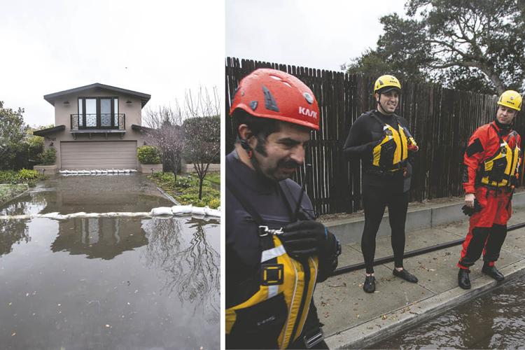
Cal Fire personnel stand by in a residential neighborhood near the Carmel Lagoon that experienced flooding on Thursday, Jan. 28. The crew helped evacuate 2,500 people from 700 homes in the early morning because of flood risk. No injuries were reported.
In Carmel, as the Carmel River built up enough force to breach the sandbar to meet the ocean, it was an unusually high tide. The lagoon level rose, flooding nearby homes and resulting in the evacuation of 2,500 residents. One wetsuit-clad firefighter responding to the scene made a similar observation about how the damage from this storm compares to years past: “There wasn’t too much panic. Most people have been here for a long while. So isn’t the first time they’ve experienced it.”


(0) comments
Welcome to the discussion.
Log In
Keep it Clean. Please avoid obscene, vulgar, lewd, racist or sexually-oriented language.
PLEASE TURN OFF YOUR CAPS LOCK.
Don't Threaten. Threats of harming another person will not be tolerated.
Be Truthful. Don't knowingly lie about anyone or anything.
Be Nice. No racism, sexism or any sort of -ism that is degrading to another person.
Be Proactive. Use the 'Report' link on each comment to let us know of abusive posts.
Share with Us. We'd love to hear eyewitness accounts, the history behind an article.