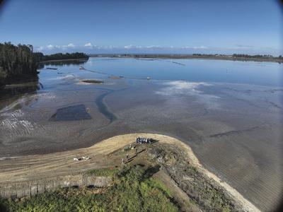

After 13 years of planning and building, the Hester Marsh Restoration Project had its unofficial “ribbon-cutting” moment over the weekend of Nov. 15-17. Project researchers, managers and volunteers gathered at the marsh on the edge of Elkhorn Slough to observe how the newly completed marsh interacted with water seeping in with the King Tides.
The key question: Were the final plans for the marsh designed at the correct elevation? If the marsh was built to plan, observers should see the water at high tide cover the marsh’s surface – only slightly. And at 9:35am on Friday, Nov. 15, that is exactly what they observe.
“We are building this marsh for the future,” says Monique Fountain, director of Elkhorn Slough National Estuarine Reserve’s Tidal Wetland Program. “If you want to have a beautiful, healthy, lush, green marsh right now, you build it lower. If you want a marsh for the future, you build it a little bit higher. And that’s what we did.”
The 147-acre restoration project is designed to evolve over time, with its higher elevation ensuring resilience to rising sea levels over the next 30 years. Currently dry except during extreme tides, the marsh is expected to accumulate sediment from tidal flows, gradually submerging while also slowing seawater’s movement into Elkhorn Slough.
“Now we watch,” Fountain says.
There is perhaps no better place in Monterey County to get a glimpse into the future of rising sea levels than Elkhorn Slough during king tides.
The Slough has transformed significantly over the last half-century; wetland areas were diked and drained, exposed to increased tidal energy due to the construction of the Moss Landing Harbor mouth, and new infrastructure has altered the ecology. All of this has contributed to subsidence, or sinking, which has impacted the habitat and marshland further inland.
A king tide event today almost entirely swallows the bridge at South Marsh Loop trail, and the railroad that cuts through the Slough will sit in shallow water. While it’s difficult to put an exact timeline on sea level rise over the long-term, the Ocean Protection Council’s updated “State of California Sea-Level Rise Guidance” report provides more certainty about the next 30 years and highlights the risks storms and rising seas pose to northern Monterey Bay’s shoreline.
The Hester Marsh project’s success brings some good news. Not only will it help to mitigate the impacts of rising seas on inland habitats in the coming years, but it also provides a potential blueprint for a related project focused on adapting public infrastructure while restoring the surrounding ecosystems.
“It’s taken 13 years to do this, now we’re ready to incorporate infrastructure, the railroad and the roadway,” Fountain says.
While the implementation of the Hester Marsh restoration is complete, the next step will be to observe hydrological function, species success, vegetation rebuilding and more. “It’s a living laboratory, which is so cool,” Fountain says. “Now, we can see how the system responds.”


(0) comments
Welcome to the discussion.
Log In
Keep it Clean. Please avoid obscene, vulgar, lewd, racist or sexually-oriented language.
PLEASE TURN OFF YOUR CAPS LOCK.
Don't Threaten. Threats of harming another person will not be tolerated.
Be Truthful. Don't knowingly lie about anyone or anything.
Be Nice. No racism, sexism or any sort of -ism that is degrading to another person.
Be Proactive. Use the 'Report' link on each comment to let us know of abusive posts.
Share with Us. We'd love to hear eyewitness accounts, the history behind an article.