
David Schmalz here, thinking about a term I first heard in 2015, as I was touring the Big Sur Land Trust’s property known as Odello East (102.5 acres just east of Highway 1 and south of the Carmel River). There, the Odello family, starting in 1924, transformed the historical floodplain into an ag field to grow artichokes, and the river’s natural path to the sea became constricted.
The idea behind the term “green infrastructure” is this: Instead of building man-made infrastructure to try to channel the river’s energy during major storm events—an expensive and ultimately futile pursuit—reclaim the floodplain to let the land do the work, as it had for millennia.
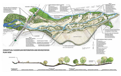
And the reason it’s on my mind is because tomorrow, Friday June 10, the California Coastal Commission will consider whether to grant a coastal development permit to the Big Sur Land Trust for such a reclamation project to move forward; the agency’s staff recommends approval, with conditions (as are standard with such permits).
The Big Sur Land Trust has been working on the plan—called the Carmel River Floodplain Restoration and Environmental Enhancement project, aka Carmel River FREE—since 2010, but the idea has been in the ether since the 1990s. That’s because of a major 1995 winter storm that made the Carmel River so powerful that it swept the Highway 1 bridge out to sea, never to be seen again. Three years later, an extraordinarily wet winter flooded the lower Carmel Valley as the river overspilled its banks, turning the lower valley into what looked like a lake.
Both of those events happened at least in part because when the Odello East property was converted to ag land many decades ago, levees were built along a curve in the river to keep the fields from flooding, forcing all of the rushing water into a narrower river channel—a bottleneck, of sorts.
Big Sur Land Trust’s plan is to move the earth at various points in the levee and create a series of braided channels on the property both east and west of the highway (and under it), so that when the water gets high enough, it has other pathways to reach the Carmel Lagoon and ultimately the sea. It’s like releasing a pressure valve.
And aside from just protecting property, the project boasts a suite of other benefits: it will create habitat for wildlife, including islands in the floodplain where animals can safely ride out the storm, as well as trails on the property and, finally, public access to the Monterey Peninsula Regional Park District’s parking lot built on the south of the property in 2016; it’s remained closed due to safety concerns because there’s no left-hand turn lane off Highway 1 to access it. Included in Carmel River FREE are plans to build such a lane.
Per the Coastal Commission’s staff report Big Sur Land Trust’s work on the first phase of the project—the land east of the highway—is expected to commence late this year. Construction of its second phase—both west of and under the highway (a bridge will be built)—will start in early 2024.
The project has similar benefits (flood control, etc) to the Land Trust’s Carr Lake project in Salinas, which is the subject of this week’s cover story. And it's further evidence that, when it comes to conservation and restoration, Big Sur Land Trust pulls off the rare combination of both dreaming big and getting things done.
We’re all the better for it.

(2) comments
Whoops!
Error above!
Here is proper link for David Schmalz excellent article from 2018? https://www.montereycountyweekly.com/news/local_news/as-seawater-intrusion-advances-new-farmland-puts-marina-s-water-supply-in-peril/article_b35ca7e0-f66e-11e7-b541-57771b472126.html
David Schmalz is an excellent writer who picks very important matters to write on.
This is one example and here is another @ https://www.linkedin.com/comm/me/profile-views?midToken=AQG7WCuXf68_Iw&midSig=1AYg9pTQcwSag1&trk=eml-b2_professional_identity_digest_02-wvmp-1-text&trkEmail=eml-b2_professional_identity_digest_02-wvmp-1-text-null-t8xu3%7El47t7ff9%7Eoe-null-neptune%2Fme%2Eprofile%7Eviews&lipi=urn%3Ali%3Apage%3Aemail_b2_professional_identity_digest_02%3Br30R4tENTKWTBuA1z7IhCA%3D%3D .
This article is about what is called an "NBS" ... nature based solution and is the best way for us to proceed, going forward as it is the best way to deal with "slr" ... sea water intrusion, the greatest threat to the vast ajority of the water, food, and natural systems/real estate assets of this planet's 5th biggest and first most important COMMUNITY (OUR'S!!!) @ https://twitter.com/DouglasDeitch/status/1374672809163550720 .
What we are talking about here is "farmlands back to wetlands" ... the very same nbs approach to tackling our local water woes that Monterey Bay Conservancy has been propsoing for us here since around 1994 run down w/ Zmudowski Beach Pilot Project @ http://dougdeitch.com (a fb page)
Welcome to the discussion.
Log In
Keep it Clean. Please avoid obscene, vulgar, lewd, racist or sexually-oriented language.
PLEASE TURN OFF YOUR CAPS LOCK.
Don't Threaten. Threats of harming another person will not be tolerated.
Be Truthful. Don't knowingly lie about anyone or anything.
Be Nice. No racism, sexism or any sort of -ism that is degrading to another person.
Be Proactive. Use the 'Report' link on each comment to let us know of abusive posts.
Share with Us. We'd love to hear eyewitness accounts, the history behind an article.