Signs of a tiny human in uphill flight from an enormous wave remind users of Pacific Grove’s Recreation Trail what to do in case of a tsunami: Run to higher ground. But the latest data show the danger zone isn’t limited to the coastline.
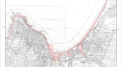
Catastrophic waves could flood as far inland as Window on the Bay Park in Monterey and almost to the intersection of Fremont and Canyon Del Rey boulevards in Seaside, according to new maps by the California Geological Survey, California Emergency Management Agency and University of Southern California.
For emergency response planners, the key factor is population density. While the Carmel River floodplain, Elkhorn Slough wetlands and North County ag fields are mapped as extensive flood zones, planners are more concerned with low-lying residential areas such as the neighborhoods surrounding Peninsula lakes and Moss Landing.
“It’s the loss of life that concerns us most,” says Phil Yenovkian, emergency planner with the Monterey County Office of Emergency Services.
For Monterey Bay, possible tsunami sources include earthquakes along fault lines in the Pacific Northwest, Alaska, Japan, Chile and Pacific islands.
Another danger lurks just offshore: A landslide in the Monterey Submarine Canyon could trigger a tsunami and cause heavy flooding in Moss Landing, according to Aggeliki Barberopoulou, research assistant professor at the USC School of Engineering. “You could have instability of these hills underneath the water,” Barberopoulou says.
The shoreline’s pointy shape intensifies the risk, she adds, focusing waves into the Moss Landing area, which lacks neighboring Marina’s protective dunes and cliffs.
The new maps replace an older set that shows even greater potential tsunami damage, with flooding almost to North Salinas. “It’s actually a rosier scenario,” Yenovkian says. “Once you have the extent of the tsunami threat analyzed, you can prepare for it.”
The local OES is in the process of making the county “tsunami-ready,” he adds. The late September quake in Samoa provided a dress rehearsal: A tsunami warning put coastal Monterey County on alert, closing state parks and P.G. beaches. “Buoys are sensitive, and we watch those,” he says.
If a tsunami were to come frothing toward Monterey Bay, the OES – which shares space with the 911 Center in Salinas – would launch into emergency mode: coordinating with law enforcement agencies, alerting residents and designating evacuation routes.
For people on the shoreline when a tsunami approaches, Yenovkian’s advice remains consistent with the trail signs in P.G. “It’s pretty simple: Just run up the hill as fast as you can.”


(0) comments
Welcome to the discussion.
Log In
Keep it Clean. Please avoid obscene, vulgar, lewd, racist or sexually-oriented language.
PLEASE TURN OFF YOUR CAPS LOCK.
Don't Threaten. Threats of harming another person will not be tolerated.
Be Truthful. Don't knowingly lie about anyone or anything.
Be Nice. No racism, sexism or any sort of -ism that is degrading to another person.
Be Proactive. Use the 'Report' link on each comment to let us know of abusive posts.
Share with Us. We'd love to hear eyewitness accounts, the history behind an article.