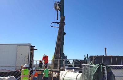
In its ongoing quest for a new Monterey Peninsula water supply, California American Water is pulling 200-foot tubes out of the Moss Landing beach. The goal: a clear blueprint of the underground architecture – key to a water-rights hurdle in Cal Am’s desalination project.
Only three of 14 bore holes have been drilled so far. But early results confirm what Cal Am had expected: a shallow aquifer (containing seawater) for the first 140 feet, then a 40-foot solid layer called an aquitard, and finally a lower aquifer (containing fresh groundwater).
If Cal Am can stay out of that lower aquifer, it may be able to soothe Salinas Valley farmers’ concerns that the desal project could draw from their water supply.
“Now we know [the aquifers are] separated,” Cal Am spokeswoman Catherine Bowie says. “The preliminary results are encouraging, but we still have a ways to go in terms of completing the testing.”
The timing is tricky. Cal Am hopes to construct its test intake well by February, because it’s only allowed to draw sample water through March to protect the endangered snowy plover. Otherwise it’ll have to wait until October 2014.
But before it can break ground at the Cemex property, Cal Am must release an initial environmental study, followed by public comment and approval from the Marina Planning Commission and the California Coastal Commission.
“The stars need to line up,” Cal Am Engineering Manager Ian Crooks told the Monterey Peninsula Regional Water Authority’s Technical Advisory Committee (TAC) Oct. 7.
“I’m concerned [a delay] could have impacts on the overall schedule of the project,” Carmel Mayor and TAC Chair Jason Burnett says. “This, for me, is a critical pass.”
[Editor's note: The quotes from Bowie, Crooks and Burnett were not included in a shorter version of this story that appeared in print Oct. 10.]


(2) comments
The Salinas Valley floor is geologically built by sediment/alluvium from the Salinas River--a meandering river. Imagine the 'canyon' in the bay extending back up the valley toward Salinas. As the mouth of the river meets the bay, the water flow slows and clay sediment is deposited--the same phenomena as noted in many river 'deltas'. That builds/fills up the valley soil. (There are also sand bars and gravel streaks--a diverse geology that eventually becomes the coastal interface.) At the mouth of the Salinas River (Salinas-Castroville-Marina) we have a region called 'The Blanco' which is essentially a 100-150-foot thick black clay plug at the end of the river. At the interface with the bay, the confinement of this clay layer--the aquitard--falls off at a steeper grade toward the canyon in the bay. The first test hole apparently documents a site where it drops off to about 140 feet--an area that will possibly provide enough sandy (dunes aquifer) to establish a well. Depending on the size of the wells, Cal Am will need to find comparable sites to allow them to drill 7 to 20 such wells to supply enough sea water to operate their proposed desal plant. The test bore hole is the first of 14; the coast geology is very uneven. I can imagine that the north edge of the mouth of the river (Potrero Road) is most likely to fall away with the least amount of clay sediment. It is 5.5 miles south to the Cemex property which is a location closest to where the Salinas River could actually flow directly into the bay--a location more likely to have bigger and thicker deposits of clay (as shown on previous bore hole explorations). The issue is to prove that seawater can be drawn from above the aquitard. If Cal Am's wells break through the aquitard and draw from the aquifer below, they would draw from the Salinas Valley water that is confined by the aquitard and they would aggrevate the Salt Water Intrusion problem that we in the Salinas Valley have spent 70 years and $300-400 million to address.
I appreciate you reporting on there hasn't been many updates but I wanted to offer a couple of comments. The borings at Moss Landing are not complete as you have stated -- and more important, there have been no borings at the CEMEX site, the chosen location for Cal-Am's project. The borings at Moss Landing only give an indication of what the hydrogeology is like at that location -- not at the CEMEX site. Unless and until we have the complete hydrogeologic investigation information for the CEMEX, we do not know if Cal-Am can pump only seawater as proposed and/or the impacts and harm to the Salinas River Groundwater Basin.
The Peninsula along with the Salinas Valley deserve to have all of the information prior to a decision being made -- so we can be assured that the best decision is in fact being made.
Welcome to the discussion.
Log In
Keep it Clean. Please avoid obscene, vulgar, lewd, racist or sexually-oriented language.
PLEASE TURN OFF YOUR CAPS LOCK.
Don't Threaten. Threats of harming another person will not be tolerated.
Be Truthful. Don't knowingly lie about anyone or anything.
Be Nice. No racism, sexism or any sort of -ism that is degrading to another person.
Be Proactive. Use the 'Report' link on each comment to let us know of abusive posts.
Share with Us. We'd love to hear eyewitness accounts, the history behind an article.