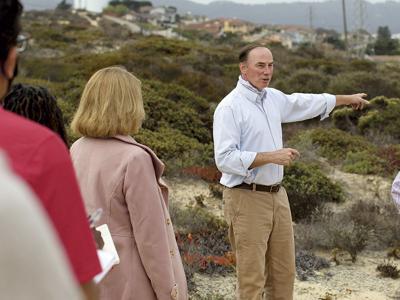

On a fair-weather morning Thursday, Aug. 19, outgoing Seaside City Manager Craig Malin leads a group of about dozen city employees and consultants to an overlook on the former Fort Ord, just east of where Broadway Avenue meets Gen. Jim Moore Boulevard.
Looking west, the expanse of the Monterey Bay opens up, and to the south, the waterfront along Cannery Row and Pacific Grove. “I just wanted us to see the space,” Malin says. “It’s such a remarkable place.”
The working title for the land the group is standing on, part of a 625-acre parcel the Army finally transferred to Seaside in the summer of 2020, is Seaside East, and before he leaves for a new job in Wisconsin, Malin wants to impress upon the group the possibilities the property has to be a gem.
“I think people haven’t seen it enough to demand access to it,” Malin says, noting the barbed-wire fence. “We have thousands of kids who live down here” – he motions to the neighborhoods downhill to the west – “that have never seen this place. That’s wrong.”
Along with city employees who will help manage the land’s future after Malin departs, also in attendance are Erin Harwayne, a planner with environmental consulting firm Denise Duffy and Associates, as well as Matt Lambert, a partner with DPZ CoDesign, a planning firm that essentially wrote the book on combating sprawl.
In February of 2020, right before the Covid-19 pandemic upended life, Seaside City Council approved a $215,000 contract with DPZ to lead a multi-day charrette so that public feedback would shape the ultimate vision for Seaside East. Delayed due to the pandemic, that charrette is now slated to run sometime in October.
“It’s as much a bottom-up process as can be achieved in pulling clear vision together,” Lambert says.
That’s intentional. After the proposed Monterey Downs mega-development went down in flames in 2016 after massive public outcry, Malin steered Seaside in a different direction: Instead of waiting for developers to submit unsolicited proposals for the city’s Fort Ord lands, take it to the public first, and then get proposals that align with the public’s vision.
The model was successful for the Campus Town development, which was approved in 2020.
On the tour, Malin also presses another point: Now that Seaside has this “free” land from the Army, upkeep and management will not be free, and the idea is for development on a yet-to-be-determined footprint to pay for it.
Which is why he brought Harwayne along, who is pointing out different species of federally protected plants on the tour. When the group reaches a point in the landscape where it transitions from chaparral to lichen-draped oak woodlands, she says, “This is a special place in the world. It’s hard to manage all this without revenue.”
To that point, Malin adds, the city is now spending $1 million to protect habitat along Eucalyptus Road, a road the Fort Ord Reuse Authority built about a decade ago.


(0) comments
Welcome to the discussion.
Log In
Keep it Clean. Please avoid obscene, vulgar, lewd, racist or sexually-oriented language.
PLEASE TURN OFF YOUR CAPS LOCK.
Don't Threaten. Threats of harming another person will not be tolerated.
Be Truthful. Don't knowingly lie about anyone or anything.
Be Nice. No racism, sexism or any sort of -ism that is degrading to another person.
Be Proactive. Use the 'Report' link on each comment to let us know of abusive posts.
Share with Us. We'd love to hear eyewitness accounts, the history behind an article.