
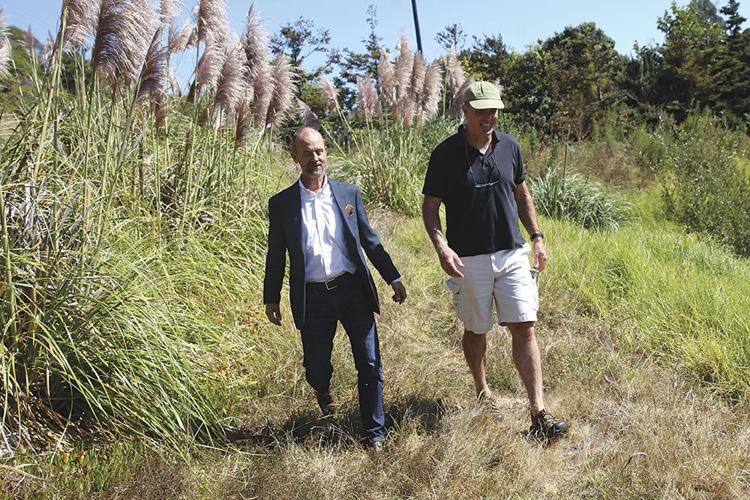


On a recent picture-perfect afternoon, CSU Monterey Bay professors Fred Watson and Scott Waltz weave their way on foot through chaparral on Del Rey Oaks property in the former Fort Ord.
The area – like much of former Fort Ord land – remains closed to the public, but they have asked for and received permission from the city, as they always do.
The two professors are the architects of the Fort Ord Regional Trail and Greenway, aka FORTAG, and they’re leading a tour for one.
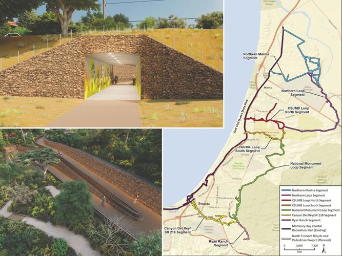
If completed, FORTAG would be an approximately 28-mile bike and pedestrian trail loop spanning the former Fort Ord from Marina to Del Rey Oaks, and connecting to the Rec Trail on the coast at both its northern and southern ends. Not including the Rec Trail, it would be about 20 miles of new trail or pathway.
Watson and Waltz are walking to higher ground for a better look at the rolling, chaparral-carpeted dunes the trail would ultimately pass through, and the higher they go, the expanse of Monterey Bay, and the Peninsula, opens up. It is land, and views, the public has never seen.
“That’s the real principle of FORTAG,” Watson says, with an Australian accent. “The recognition that there are a hundred little secret spots in Fort Ord that are just next to where everybody lives but that sort of have an ambiguous public access, but are really beautiful.”
While picking his steps through the chaparral, Waltz concurs.
“People know the mountain biking areas on the northern part of Fort Ord,” Waltz says, “but I think especially [because this] area is inaccessible, fewer people realize just how beautiful the southern part is, and you can start to get a sense of that right now. You can see the dunes as they lay out.”
Atop a hill, Watson explains how they mapped the trail through the sprawling dunes, in order to both maximize views and stay below a 12-percent gradient, as required by the federal Americans with Disabilities Act.
“Every time we do a line, we run it through this analysis software that tells us the gradient of every bit of our line, and if there’s too-steep bits, we move the line and we do it again, and we just keep wiggling it until we get a line,” Watson says.
Watson has also applied that same GIS expertise – which he developed as part of his work as an environmental scientist and professor – to getting the trail to the views.
“We did a sort of viewshed analysis [in 2013 and 2014],” Watson says. “We put a dot on all the places you want to look at, and all the places that you want to look at stuff from.”
In doing that, the software returns a “heat map,” as Watson calls it, where the red spots show where the views are. Then Watson points to a hill in the forefront, where FORTAG would crest.
“You go up right there, and you’re going to be able to see a bunch of the ocean, a bunch of the Peninsula, and if you’re hiking at Jacks Peak, you look across to here,” Watson says, as if he were on top of that hill. “And so we thought, this is a good spot, let’s try to make the trail go through here. And we did it for 20 or 30 spots.”
In that moment, with the expanse of the Monterey Bay and the Peninsula in view, the dream of FORTAG feels so real, you can almost feel the wind blowing through your hair.

Scott Waltz (left) and Fred Watson walk through Work Memorial Park. If the Del Rey Oaks FORTAG segment is approved, it would finally give the public access to land that’s been intended to be a park since 1955.
THE DREAM WAS BORN out of the closure of Fort Ord, in 1994. It was identified as “Objective F.”
Like every stated objective in the Fort Ord Base Reuse Plan, which the Fort Ord Reuse Authority’s board adopted in 1997 to dictate future development on the former base, it was succinct: “Create a unified system of hiker/biker and equestrian trails which links all sectors of the former Fort Ord and encourages alternative means of transportation.”
And like many of the objectives contained in that plan, 24 years have passed, and not one bit of it has been achieved. Yet.
Enter Watson and Waltz, who, since 2013, have been trying to make that dream real.
Watson, an environmental scientist, came to Fort Ord from Australia in 1998, and has lived and worked there ever since. “When you move to Fort Ord in the late ’90s, you’re obviously aware they’re reusing this huge place, and at first you assume it will be done in a balanced, sensible way,” Watson says. “By the time we got to 2012 and 2013, it occurred to me that if you’re a cyclist or jogger, you’re constantly coming up against fences or broken curbs.”
Watson became increasingly engaged, attending transportation and planning meetings related to land use on the former Fort Ord, and he soon realized the Base Reuse Plan’s vision for biking and running trails was not being heeded.
Waltz, a social scientist and educator who came to Fort Ord in 2004, started attending FORA board meetings in 2012 on behalf of the Sierra Club. He started taking note when former FORA board member and Marina city councilmember Gail Morton kept drawing attention to the fact that a recreation corridor called for in the Base Reuse Plan, from the Fort Ord National Monument to Marina State Beach, was being encroached upon by approved developments. If that continued to happen, Waltz realized, any future hopes for such a corridor would be dashed.
Both being environmentally minded professors, Watson and Waltz had met years before, and in 2012, they started sharing notes. Ultimately, they hatched a plan: Instead of just focusing on the corridor, how about a full circuit of trails?
“Then we started thinking, ‘Let’s think big,’” Waltz says.
“We realized we were living here for potentially the rest of our lives,” Watson says, “and we realized we should pick this up. No one else was doing it.”
The seeds for the Fort Ord Regional Trail and Greenway, aka FORTAG, were planted.
The thinking at the time, Watson says, was straightforward: “We’ve got this idea, and we know a lot of people are going to like it.”
He was right, and soon, the seeds started to sprout.
WATSON AND WALTZ BROUGHT DIFFERENT SKILLS TO THE TABLE. Watson was adept at using GIS mapping software through his scientific work at CSUMB, and spent hundreds of off-hours deciphering the best possible route through each section of the trail.
Waltz took on communications and outreach, and in 2013, they started meeting with stakeholders. To date, they’ve had more than 350 meetings about FORTAG, and have met with 78 organizations.
Perhaps the most fateful of those meetings was in March 2014 where, for the first time, they met with representatives from the Transportation Agency for Monterey County, including Executive Director Debbie Hale and Deputy Executive Director Todd Muck.
Months passed, Watson says, “and at some point, Debbie reached back out to us, and said she wouldn’t mind hearing about this FORTAG a little more.”
Hale was ultimately sold on the vision, and TAMC included FORTAG in Measure X, a 2016 county-wide ballot initiative to fund $600 million of transportation projects in the county – including $20 million for FORTAG – over 30 years through a 0.375-percent increase in sales taxes.
The measure passed with 67.7 percent of the vote, and for FORTAG, it was a game-changer in terms of competing for state or federal grants, which favor jurisdictions with some skin in the game.
With Measure X approved and wind behind their sails, Watson and Waltz continued their outreach, spreading the word about the scope and vision of FORTAG to various stakeholder agencies, who welcomed the idea enthusiastically and unanimously.
TAMC began applying for state and federal grants for the project, and its first success was in January 2019, when the California Transportation Commission awarded TAMC a $10.3 million grant from the Active Transportation Program, leveraged by an additional $2 million from Measure X funds, for a 1.5-mile segment in Del Rey Oaks. (An earlier application for a federal grant through the Federal Lands Access Program for a segment in Marina was not successful.)
The project continued apace: In 2020, TAMC’s board approved the final environmental impact report for the project, and the boards of several stakeholder agencies – the cities of Del Rey Oaks, Marina and Seaside, the Monterey County Board of Supervisors and the Monterey Peninsula Regional Park District – approved the FORTAG Master Agreement, which meant, among other things, they would be responsible for maintaining the trail in their jurisdictions after it was built.
Everything seemed like it was rolling along smoothly. But not long after TAMC, in September 2020, released the conceptual design report for the project – which illustrates the basic contours of the preferred route with descriptions, maps and computer-rendered mock-ups – the rubber hit the trail in Del Rey Oaks.

(Right)If completed, FORTAG would create a 28-mile loop connecting Fort Ord to the Rec Trail in Marina and Del Rey Oaks and Seaside, about 20 miles of which would be new trail. There are also various spurs envisioned connecting to neighborhoods, businesses and CSU Monterey Bay. (Below) A conceptual rendering of the ramp leading from a tunnel under Highway 218 and up to Carlton Drive in Del Rey Oaks. (Above) A conceptual rendering of the tunnel under Highway 218 toward the Frog Pond.
IT’S JUNE 17, AT THE BEGINNING OF A VIRTUAL PUBLIC WORKSHOP TAMC hosts about the Canyon Del Rey segment of FORTAG. A quick poll is taken of the more than 90 attendees, asking them where they live; 73 percent say Del Rey Oaks.
Lindsey Van Parys, one of TAMC’s consultants for the segment, outlines the project’s history to date and where the first segment’s route is proposed to be aligned. Then Watson gives a brief overview of the project, and starts out by connecting the greater FORTAG vision to some of the most pressing issues of our time: sustainability and climate change, equity, accessibility, safety, nature, education and wellness. FORTAG, he says, attempts to address these issues on a local and regional scale. And he wants people to know what they could be missing out on if the dream is not realized, particularly in places like Del Rey Oaks, where hundreds of acres of former Fort Ord land within the city remain inaccessible to the public. If that access doesn’t come until developments are built, not only would that take years (maybe decades), but the access will likely be patchwork, and not regionally cohesive.
“If we don’t do anything, and then just wait for a big development to come along, we’re just shoehorning in the pedestrian plan and bicycle plan backwards into the specific plan of the development, and asking the developer to fix some of these regional active transportation problems that we were unable to fix. And that’s just nearly impossible,” Watson says. “If we get out in front of this, and create the active transportation network within this community before these projects come along, then they have to work with it.”
Acting Del Rey Oaks City Manager Jeff Hoyne, who is also the city’s police chief, speaks next, and stresses that the city and its police force are doing everything they can to address any public safety concerns related to the proposed route, and that the city is looking into acquiring electric bikes for its police to patrol the trail and the parks, while also being able to respond to calls for service.
But before doing all that, he gives an enthusiastic endorsement for the project.
“We hope this trail will be successful, will be welcomed by our community and will be an asset for generations to come here in Del Rey Oaks, and regionally,” Hoyne tells the group.
About an hour into the meeting, the Zoom session opens up for comments from the public, up to two minutes apiece. Of the scores who chime in over the next hour before the meeting ends, it’s evenly divided among those who support the project and those who oppose it. Among the latter, the primary concerns are about the trail facilitating homeless encampments in the small city of about 1,500 residents, crime and the potential degradation of the environment at the Frog Pond Wetland Preserve.
But probably the most vociferous opposition came from residents on Angelus Way, a quiet, dead-end street the segment is proposed to travel on, between the city’s Work Memorial Park to the west and Del Rey Park to the east.
No changes are proposed for the street, not even striping – just two wayfinding signs on the western and eastern ends.
Nonetheless, resident Tom Rivelli, who lives just off of Angelus Way, filed at a Notice of Intent to Circulate a Petition at Del Rey Oaks City Hall on July 22 for the purpose of qualifying a ballot initiative measure titled “Opposition to the Fort Ord Regional Trail and Greenway (FORTAG) Project through the City of Del Rey Oaks.”
If the measure were to ever reach the ballot and be approved by 50 percent or more of the city’s voters, it would prohibit the city from allowing a tunnel to be built under Highway 218 (aka Canyon Del Rey) to connect FORTAG to the Frog Pond, and would limit the trail’s route through the city to three major arteries: Highway 218, Gen. Jim Moore Boulevard and South Boundary Road.
Five days after Rivelli filed his petition, at a July 27 meeting of Del Rey Oaks City Council, Councilmember Scott Donaldson requested that TAMC come to the council’s next meeting, in August, to give a presentation about the feasibility of rerouting FORTAG onto Highway 218.

Fred Watson inspects invasive weeds at Work Memorial Park. If the Del Rey Oaks FORTAG segment is approved, the wetland would be restored and many invasives removed.
ON A LATE AUGUST AFTERNOON, just a few days after TAMC’s consultants outlined the feasibility of putting FORTAG on Highway 218 to the Del Rey Oaks City Council, Watson and Waltz lead the way from City Hall west down Highway 218, cars zipping by, to illustrate firsthand how difficult such a reroute would be logistically, and politically.
For one thing, in order to have a two-way, separated bike and pedestrian path along the highway, it would require widening the road significantly into Caltrans’ right of way along the road, which extends up to 24 feet from the south side of the road (as well as to the north, to a lesser extent).
That would encroach on the properties of several homes, many of which have fences along the road, or just below. If the Highway 218 alternative were built, it would be in backyards which, instead of looking up at a tree-lined hillside, would face a retaining wall up to 16 feet tall.
One of these homes is next door to Rivelli’s house.
At the rear of Safeway, the gateway to the Del Rey Oaks segment, the two lead the way down into the city’s Work Memorial Park, a former driving range with lush plant life that FORTAG would restore to its natural state as a wetland.
After hiking up and around a landscaping business, the city’s tennis courts and a community butterfly garden,Watson and Waltz walk along Angelus Way, where some small yard signs read “Reroute FORTAG; Don’t let tunnel vision ‘Rec’ our town.” After leaving the street they pass by a dog park, and then land along a creek near City Hall. Which brings them to another serious point of contention among Del Rey Oaks residents: a proposed tunnel under the road connecting to the Frog Pond.
While controversial, the proposed route of the first 1.5-mile segment, which is projected to cost about $12 million – $10.1 million of which would come from a grant already awarded by the state – would still be approximately $10 million cheaper than running FORTAG down the highway, according to TAMC’s consultants, and it’s an alternative that does not yet have, and will not likely receive, state buy-in. (Bike and pedestrian paths on highways don’t score well, for obvious reasons, cost and safety chief among them.)
As for the Frog Pond – a principal concern among some Del Rey Oaks residents opposing FORTAG – they stress that the first segment will not touch onto any existing trail in the park, except for a short pedestrian connection. They also emphasize that the route for a potential connective segment up into Fort Ord from the Frog Pond remains open for consideration in the future – and it need not travel onto the existing trail either.
Nonetheless, both on social media and in public meetings, FORTAG opponents have claimed the path will destroy the park’s natural setting and somehow disrupt its ecology. Yet MPRPD, which owns the park, has been and remains fully supportive of the project. (Del Rey Oaks residents had the chance to own the land outright more than 40 years ago, but a 1974 city bond initiative for its purchase failed at the ballot box, and the park district bought it three years later.)
Before the district acquired the Frog Pond property in 1977, it was used for cattle grazing, as appears to have been the case for the preceding century, since Juan A. Munoz acquired a patent for Rancho Noche Buena in 1862, according to the district’s 1994 management plan for the park. Furthermore, it reads, “More recently, the construction of Highway 218, North-South Road (now Gen. Jim Moore Boulevard) and the Noche Buena Subdivision has permanently disrupted the natural hydrologic cycle and system for the Frog Pond.”
In other words, the entire existing ecosystem is the product of human development.
It’s pained Watson and Waltz to see their project’s vision assailed for being insensitive to the environment – their concern for the environment is how the two became friends.
“When we first conceived this, we were as much about wildlife corridors as about paths, if not more. We’re fundamentally tree-huggers who want to get into open spaces and see them preserved,” Watson says. “FORTAG is fundamentally about the preservation of nature, at the global scale, and local scale.”
DESPITE OVERWHELMING SUPPORT from the Monterey Peninsula community writ large, many potential pitfalls remain for FORTAG’s first proposed segment, in part because Del Rey Oaks is such a small city.
Rivelli turned in the signatures to qualify his ballot initiative to Del Rey Oaks City Hall on Sept. 8. City Clerk Karen Minami says, by her initial raw count, signatures appear to number 413‚ well over the required 123.
“Read the petition carefully,” Rivelli says. “The purpose is to ask for a vote by the people of Del Rey Oaks before this thing goes through. That’s what this is about. Personally, I don’t want it in our neighborhood. I’m all for a Rec Trail, but not through my neighborhood. If I sound pissed off, that’s because I am.”
Minami will turn in the signatures for verification to the County Elections Department and, if verified, she expects the initiative will be voted on by the city council on Oct. 26.
If ultimately the Del Rey Oaks City Council, or the voters, make the ballot initiative a law, the entire project could die on the vine.
“The whole FORTAG system is in the balance with this Del Rey Oaks situation,” Watson says. “It’s worth remembering the highest purpose here – the highest purpose is climate change,” he reiterates.
The reason this segment is so critical is it’s the first to be awarded grant funding, and if it fails politically, it could conceivably make it much tougher going forward to get such funding, not to mention losing a critical connective segment of the outer loop.
Waltz, however, is a bit more optimistic.
“We started as a grassroots effort. It’s really up to residents to make this their own regional project. Regardless of what happens in Del Rey Oaks, Fred and I will work with other cities on other segments,” he says. “Maybe we’ll just need to come back to Del Rey Oaks.”
Maybe. But it’s a tough city to read: Both Rivelli and Mayor Alison Kerr, a FORTAG proponent, say that about 9 of 10 people they speak to are against, or for (respectively) the proposed FORTAG route through the city.
It’s expected the Del Rey Oaks City Council will vote sometime early next year on whether to approve the segment’s final design as it travels through the city, unless a ballot initiative were to derail it first. And perhaps one could derail it after.
TAMC, for its part, will remain committed to the greater vision, and Muck, its deputy executive director, says the agency will continue applying for grants for other segments. (Muck will soon become the agency’s executive director as Hale is retiring.)
But he stresses it won’t be easy, especially if this first segment falls apart.
“There are way more people requesting money than there is money available, and there are plenty of places to spend the money other than on FORTAG in Monterey County,” Muck says. “It’s important to show you can deliver on what you promise, and this is the first funded segment.”
It’s been a long, long time since anything ambitious, complex and somewhat controversial has been achieved on the Monterey Peninsula. Proposed water desalination projects have either failed or stalled. The reuse of Fort Ord has, so far, been an historic failure.
FORTAG is not even remotely as controversial as either of those two things, but given the bumps in the road it’s facing right now, it calls into question whether the region is capable of doing hard things, and whether its residents and future generations can have nice things.
Right now, for better or worse, it appears the answers to both of those questions will come from the residents and elected officials in tiny Del Rey Oaks.
(0) comments
Welcome to the discussion.
Log In
Keep it Clean. Please avoid obscene, vulgar, lewd, racist or sexually-oriented language.
PLEASE TURN OFF YOUR CAPS LOCK.
Don't Threaten. Threats of harming another person will not be tolerated.
Be Truthful. Don't knowingly lie about anyone or anything.
Be Nice. No racism, sexism or any sort of -ism that is degrading to another person.
Be Proactive. Use the 'Report' link on each comment to let us know of abusive posts.
Share with Us. We'd love to hear eyewitness accounts, the history behind an article.