The rainstorms sweeping in from the Pacific Ocean began to pound Central California on Christmas Eve 1861 and continued virtually unabated for 43 days.
The deluges quickly transformed rivers running from the Sierra Nevada along the state’s eastern border into raging torrents that swept away entire communities and mining settlements. The rivers and rains poured into the state’s vast Central Valley, turning it into an inland sea 300 miles long and 20 miles wide. Thousands of people died, and one quarter of the state’s estimated 800,000 cattle drowned.
Downtown Sacramento was submerged under 10 feet of brown water filled with debris from countless mudslides on the region’s steep slopes. California’s Legislature, unable to function, moved to San Francisco until Sacramento dried out – six months later. By then, the state was bankrupt.
A comparable episode today would be infinitely more devastating. The Central Valley is now home to more than 6 million people, 1.4 million of them in Sacramento. The land produces about $20 billion in crops annually, including 70 percent of the world’s almonds – and portions of it have dropped 30 feet in elevation because of extensive groundwater pumping, making those areas even more prone to flooding. Scientists who recently modeled a similarly relentless storm that lasted only 23 days concluded it would cause $400 billion in property damage and agricultural losses. Thousands of people could die unless preparations and evacuations worked very well.
Was the 1861-62 flood a freak event? It appears not. New studies of sediment deposits in widespread locations indicate cataclysmic floods of this magnitude have inundated California every two centuries or so for at least the past two millennia. The 1861-62 storms also pummeled the coastline from northern Mexico and Southern California up to British Columbia, creating the worst floods in recorded history.
Climate scientists now hypothesize these floods were caused by atmospheric rivers, a phenomenon you may have never heard of. And they think California is overdue for another one.
Ten Mississippi Rivers, One Mile High
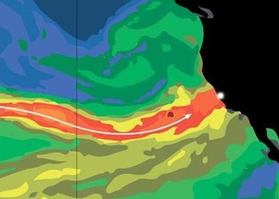
Atmospheric rivers are long streams of water vapor that form about 1 mile up in the atmosphere. They are only 250 miles across but extend for thousands of miles – sometimes across an entire ocean basin such as the Pacific. These conveyor belts of vapor carry as much water as 10 to 15 Mississippi Rivers from the tropics and across the middle latitudes. When one reaches the U.S. West Coast and hits inland mountain ranges, such as the Sierra Nevada, it is forced up, cools off and condenses into a vast quantity of precipitation.
People on North America’s West Coast have long known about “pineapple expresses,” storms that pour in from the tropics near Hawaii and dump heavy rain and snow for three to five days. It turns out they are just one configuration of an atmospheric river. As many as nine atmospheric rivers hit California every year, according to recent investigations. Few of them end up being strong enough to yield true megafloods, but even the “normal” storms are about as intense as rainstorms get in the rest of the U.S., so they challenge emergency personnel, flood-control authorities and water managers.
WITH ATMOSPHERIC RIVERS LIKELY TO BECOME MORE FREQUENT AND LARGER AND WITH SO MANY PEOPLE NOW LIVING IN THEIR PATHS, SOCIETY WOULD BE WISE TO PREPARE.
Atmospheric rivers also bring rains to the west coasts of other continents and can occasionally form in unlikely places. For example, the catastrophic flooding in and around Nashville in May 2010 – which caused some 30 deaths and more than $2 billion in damages – was fed by an unusual atmospheric river that brought heavy rain for two relentless days up into Tennessee from the Gulf of Mexico. In 2009, substantial flooding in southern England and various parts of Spain was also caused by atmospheric rivers. But the phenomenon is best understood along the Pacific Coast, and the latest studies suggest these rivers of vapor may become even larger as the climate warms.
Despite their incredible destruction, atmospheric rivers were discovered only recently – and serendipitously.
In January 1998, the National Oceanic and Atmospheric Administration (NOAA)’s Environmental Technology Laboratory began a project called CALJET to improve the forecasting of large storms on the California coast. The lab’s research meteorologist, Marty Ralph, and others flew specially outfitted aircraft over the North Pacific into an approaching winter storm to directly measure the conditions. That storm was described as a “jet” – a zone of high winds. The researchers found the single storm, for several days running, was carrying about 20 percent of the ocean’s surface, high enough to have been difficult to identify using traditional meteorological observations from the ground.
Also in 1998, researchers Yong Zhu and the late Reginald Newell, then at the Massachusetts Institute of Technology, noticed an odd feature in simulations of global wind and water vapor patterns that had been made by the European Center for Medium-Range Weather Forecasts. They found that, outside of the tropics, an average of about 95 percent of all vapor transport toward the poles occurred in just five or six narrow bands, distributed somewhat randomly around the globe, that moved west to east across the middle latitudes. To describe these bands, they coined the term “atmospheric rivers.”
At about the same time, satellites carrying the new Special Sensor Microwave Imager were for the first time providing clear and complete observations of water-vapor distributions globally. The imagery showed water vapor tended to concentrate in long, narrow corridors that extend most often from the warm, moist air of the tropics into drier, cooler regions. The tentacles appeared and then fell apart on timescales from days to a couple of weeks.
Researchers soon put these three remarkably complementary findings together. Since then, scientists have conducted a growing number of studies to better characterize West Coast atmospheric rivers. New observatories with upward-looking radars and wind profilers have been established to watch for them. NOAA’s Hydrometeorological Testbed program is peering farther inland to find out what happens when atmospheric rivers penetrate the interior.
Using data from these networks, forecasters are getting better at recognizing atmospheric rivers in weather models and at predicting their arrivals. In recent years, some storms have been recognized more than a week before they hit land. Atmospheric rivers are also appearing in climate models used to predict climate changes. Forecasters are beginning to warn the public about extremely heavy rains earlier than they would have in the past. This improvement is providing extra time to prepare.
A Megaflood Every Century?
Despite greater scientific understanding, the 1861-62 floods are all but forgotten. Communities, industries and agricultural operations in California and the West have spent the past century spreading out onto many of the same floodplains that were submerged 150 years ago. Residents are unaware or unwary of the obvious risks to life and property. Meanwhile, anxious climatologists see accumulating evidence a megastorm could happen again – and soon.
The concerns grow out of the research looking 2,000 years back to piece together the occurrence and frequency of past floods, like detectives returning to a crime scene of long ago. They are sifting through evidence archived in sediments from lake beds, floodplains, marshes and submarine basins. As flood waters course down slopes and across landscapes, they pick up clay, silt and sand, carrying that material in swollen currents. The rivers slow upon reaching a floodplain, marsh, estuary or the ocean, releasing their loads of sediment: first the larger gravels, then the sands, and finally the silts and clays. Nature rebuilds after such events, and over time the flood deposits are themselves buried beneath newer sediments left by normal weather. Scientists extract vertical cores from these sediments, analyze the preserved layers and date what happened when.
For example, flood deposits have been found under tidal marshes around San Francisco Bay in Northern California. Typically the inflowing river waters that spread across the marshes deposit only thin traces of the finest sediments, the clays and silts.
The more vigorous flows of major floods carry larger particles and deposit thicker and coarser layers. The flood layers can be radiocarbon-dated, which is accurate to within about 100 years. A study of the marsh cores by one of us (Ingram) and geographer Frances Malamud-Roam revealed deposits from massive flooding around A.D. 100, 1400 and 1650. A distinct layer from the 1861-62 event is difficult to distinguish, however, because hydraulic gold mining in the Sierra Nevada foothills during the decade before and after the flood moved enormous volumes of silt and sand that essentially wiped out whatever traces the floodwaters might have left.
Sediment cores taken from beneath San Francisco Bay reveal in 1400, the bay was filled with freshwater (as it was during the 1861-62 event), indicating a massive flood.
Geologists have found more evidence along the coast of Santa Barbara, where sediments settle to the seafloor every spring (forming a light-colored layer of algae known as diatoms) and again in winter (forming a dark-colored silt layer). Because the oxygen concentrations in the deep waters there are inhospitably low for bottom-dwelling organisms that would usually churn and burrow, the annual sediment layers have remained remarkably undisturbed for thousands of years. Sediment cores there reveal six distinct megafloods that appear as thick gray silt layers in A.D. 212, 440, 603, 1029, 1418 and 1605. The three most recent dates correlate well with the approximate 1100, 1400 and 1650 dates indicated by the marsh deposits around the San Francisco Bay – confirming that widespread floods have occurred every few hundred years.
The thickest flood layer in the Santa Barbara Basin was deposited in 1605. The sediment was 2 inches thick a few miles offshore. The 440 and 1418 floods each left layers more than an inch thick. These compare with layers of 0.24 and 0.08 inches near the top of the core that were left by large storms in 1958 and 1964, respectively, which were among the biggest of the past century. The three earlier floods must have been far worse than any we have witnessed.
Evidence of enormous flooding has also been found about 150 miles northeast of San Francisco Bay, in sediment cores taken from a small lake called Little Packer that lies in the floodplain of the Sacramento River, the largest river in Northern California. During major floods, sediment-laden floodwaters spill into the lake and the sediment settles to the bottom, forming thick, coarse layers. Geographer Roger Byrne of the University of California, Berkeley, and his then-graduate student, Donald Sullivan, used radiocarbon dating to determine that a flood comparable to the 1861-62 catastrophe occurred in each of the following time spans: 1235-1360, 1295-1410, 1555-1615, 1750-70 and 1810-20. That is, one megaflood every 100-200 years.
THE ATMOSPHERIC RIVERS COULD CAUSE $400 BILLION IN PROPERTY DAMAGE AND AGRICULTURAL LOSSES. BUSINESS AND EMPLOYMENT INTERRUPTIONS COULD BRING THE TOTAL COSTS TO MORE THAN $700 BILLION.
Certain megafloods have left records of their passage in narrow canyons in the Klamath Mountains in the northwestern corner of California. Two particularly enormous deposits were laid down around 1600 and 1750, once again agreeing with the other data.
When taken together, all the historical evidence suggests that the 1650 flood was at least 50 percent greater than any of the other megafloods. And although the radiocarbon dates have significant uncertainties and could be reinterpreted if dating methods improve, the unsettling bottom line is that megafloods as large or larger than the 1861-62 flood are a normal occurrence every two centuries or so. It has now been 150 years since that calamity, so it appears that California may be due for another episode soon.
Disasters More Likely
Ironically, atmospheric rivers that set up over California are not all bad. The smaller ones that arise annually are important sources of water. By analyzing the amount of rain and snow that atmospheric rivers brought to the U.S. West Coast in recent decades, along with records about long-term precipitation, snowpack and stream flow, researchers have found that between 1950 and 2010, atmospheric rivers supplied 30 to 50 percent of California’s water in the span of only 10 days each year. They are finding similar proportions along the rest of the West Coast. In the same time period, however, the storms also caused more than 80 percent of flooding in California rivers and 81 percent of the 128 most well-documented levee breaks in California’s Central Valley.
Because atmospheric rivers play such terrible roles in floods and such vital roles in water supply, it is natural to wonder what might happen as climate change takes firmer hold. Recall that Zhu and Newell first coined the term “atmospheric river” to describe features they observed in computer models of weather. Those models are closely related to models used to project the future consequences of rising greenhouse gas concentrations. Scientists do not program atmospheric rivers into weather and climate models; the rivers emerge as natural consequences of the way the atmospheric water cycle works when the models are let loose to simulate the past, present and future. Thus, the rivers also appear in climate projection models used in Intergovernmental Panel on Climate Change assessments.
A recent review by one of us (Dettinger) of different climate models from around the world indicates atmospheric rivers will likely continue to arrive in California throughout the 21st century. In the projections, air temperatures get warmer by about 4 degrees Fahrenheit, on average, because of increasing greenhouse gas concentrations. Because a warmer atmosphere holds more water vapor, atmospheric rivers could carry more moisture.
On the other hand, because the tropics and polar regions are projected to warm at different rates, winds over the midlatitude Pacific are expected to weaken slightly. The rain atmospheric rivers produce is primarily a product of the amount of vapor they hold and how fast they are moving, and so the question arises: Will moister air or weaker winds win out? In six of the seven climate models, the average rain and snow delivered to California by future atmospheric rivers increases by an average of about 10 percent by the year 2100. Moister air trumps weaker winds.
With atmospheric rivers likely to become more frequent and larger, and with so many people now living in their paths, society would be wise to prepare.
Scientists at the U.S. Geological Survey (USGS) recently developed the scenario mentioned at the start of this article: a megastorm that rivaled the 1861-62 storm in size but lasted 23 days instead of 43 (so no one could claim the scenario was unrealistic). To further ensure the scenario, which was eventually dubbed ARkStorm (Atmospheric River 1,000 Storm), was as realistic as possible, scientists constructed it by stitching together dates from two of the largest storm sequences in California from the past 50 years: January 1969 and February 1986.
When project leaders ran the events of ARkStorm through a variety of weather, runoff, engineering and economic models, the results suggested sustained flooding could occur over most lowland areas of Northern and Southern California. Such flooding could lead to the evacuation of 1.5 million people. Damages and disruptions from high water, hundreds of landslides and hurricane-force winds in certain spots could cause $400 billion in property damage and agricultural losses. Long-term business and employment interruptions could bring the total costs to more than $700 billion. Based on disasters elsewhere in recent years, we believe a calamity this size could kill thousands of people. (The ARkStorm simulation did not predict deaths.)
The costs are about three times those estimated by many of the same USGS project members who had worked on another disaster scenario known as ShakeOut: a hypothetical magnitude-7.8 earthquake on the San Andreas Fault in Southern California. This “Other Big One” – a megaflood – may pose even greater risks to the Golden State than a large-magnitude earthquake. An ARkStorm is plausible for California, perhaps even inevitable.
The same promise, and warning, holds true along the western coasts of other continents. Scientists have studied atmospheric rivers in more depth along California’s coast than anywhere else in the world, but they have little reason to expect the storms would be less frequent or smaller elsewhere. The next megaflood could occur in Chile, Spain, Namibia or western Australia.
Californians, along with all residents of the West Coast, should be aware of the threats posed by atmospheric rivers and should take forecasts of storms and floods very seriously. Planners and city and state leaders should also take note as they decide on investments for the future. They who forget the past are likely to repeat it.
(1) comment
Junk Science
The cover story in this week's Weekly, The Coming Megafloods, is a typical example of the junk science being produced by AGW alarmists. The fact that the Weekly's editors would publish such nonsense is an indictment of either their reasoning ability or their integrity. The article s reporting on the fact that there's a 2000-year history of California megafloods occurring every 100-200 years, the worst of which in recent history occurred 400 years ago –150 years before the Industrial Revolution. Nevertheless, the sub reads, in part, “ . . ., and climate change could bring even more of them.” As anybody who hasn't been living on a cave is well aware, what climate change hath wrought in California is 20-years of below average precipitation resulting in, among other things the (currently) fifth largest wildfire in the State's recorded history. The article goes on to say, on the basis precisely no evidence and despite the evidence to the contrary, that “With atmospheric rivers likely to become more frequent and larger . . .”
It should be obvious to a sentient being that there's a roughly 200 years cycle of megafloods which, while reoccurrence should be anticipated and prepared for, has not been affected by the accelerating levels of atmospheric CO2 since the Industrial Revolution. Another nail in the AGW coffin.
Welcome to the discussion.
Log In
Keep it Clean. Please avoid obscene, vulgar, lewd, racist or sexually-oriented language.
PLEASE TURN OFF YOUR CAPS LOCK.
Don't Threaten. Threats of harming another person will not be tolerated.
Be Truthful. Don't knowingly lie about anyone or anything.
Be Nice. No racism, sexism or any sort of -ism that is degrading to another person.
Be Proactive. Use the 'Report' link on each comment to let us know of abusive posts.
Share with Us. We'd love to hear eyewitness accounts, the history behind an article.