
First there was Google Earth, which let people travel the world from their computer screens. Then there was Google Maps, with its Street View that allows users to virtually drive down nearly any street, viewing fronts of homes and businesses. Now, Google Trekker – which expands Street View to off-road areas – is mapping trails and parks. Monterey County is ground zero.
In fall 2014, Google and the state Department of Parks and Recreation announced they had put California’s state parks on Google Maps. By the time of the announcement, officials reported, the Google Trekker program had already started. Five of the 10 the state parks they’d mapped by then – along with the three state beaches, the one state reserve and most of the 25 trails – were in Monterey County.
Deanna Yick, a program manager for Google Maps, says the goal is to create the most comprehensive, accurate and useful park maps possible.
“When the road ends, it doesn’t mean there isn’t more to explore,” she says. “We hope that the [Google Trekker] imagery will inspire people to visit these beautiful parks in person.”
As of now, the state reports, Google has filmed more than 100 state parks and beaches. Google Maps Street View users can virtually hike more than 51 trails across Monterey County, including in Toro and Jacks Peak county parks, Andrew Molera and Pfeiffer Big Sur state parks, and eight local state beaches. It doesn’t add up to every single trail in the area, but it’s enough to give anyone with an Internet connection access to a wide range of local terrain.
“As a tourist, when planning your trip or vacation, you can go online to look at a hotel room before booking it,” State Parks spokesman Dennis Weber says. “That is what we were looking for when we partnered with Google.”
Google has invited tourism boards, nonprofits, universities, research organizations and others to collect videos of hard-to-reach places.
The Monterey County Convention and Visitor’s Bureau (MCCVB) filled out the online request form in January 2014. After a nine-month wait, Google loaned the Trekker to MCCVB for two months, October through November 2014. The bureau enlisted Big Sur Guides and Hiking to help collect imagery not only of local trails, but also of Fishermen’s Wharf and Lake El Estero.
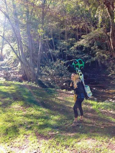
Hannah Lonergan – then a tour guide with Big Sur Guides and Hiking, now a sales associate for the Weekly – was part of that effort. She, along with colleague Hallie Heath, were tasked with mapping out about 20 places in Monterey County with the Trekker.
They shared the load of the large backpack, which weighed more than 40 pounds, making it feel like hiking with a small child riding piggyback. The Trekker contained a battery connected to an array of 15 GoPro cameras through a thick metal cable. The battery powered the cameras and a live feed that linked up to an Android phone they carried. The smartphone allowed them to start and stop the camera, and view the images the Trekker was recording. Lonergan and Heath kept a running log of where they hiked, how long the hikes took and anything else of interest.
“We looked like nerdy Ghostbusters,” Lonergan says.
The resulting images, showing 360-degree views from a hiker’s perspective, are on both Google Maps and SeeMonterey.com, the visitors bureau’s website. MCCVB officials don’t know exactly how much tourism it might bring, but they have a hunch it will. “It is a great program,” MCCVB Content Marketing Manager Allyson Thommen says.
But there are other issues at work. A number of passing hikers asked Longeran and Heath if their faces would appear in Google imagery. (They assured them their faces wouldn’t; but study of the site reveals automatic face-blurring isn’t always successful.) Others wonder aloud how Google-owned documenting of a public resource like a state park was approved and managed. After all, no official word that it was happening came until a majority of the 51 Google Trekker maps were complete. Some locals, including independent Big Sur types, decry public disclosure of a locally known trails like they do semi-secret surf breaks.
The Google Trekker program has mapped out many other wonders of the world beyond Big Sur, including the Himalayas, the pyramids of Giza, the Taj Mahal and the Galapagos Islands. Is it spying or a handy way to reach the summit without leaving your desk? A smart tool to attract tourists, or a lazy shortcut to a hiker’s hard-won reward? Either way, Google Trekker trains its lens where technology and travel are headed – into the digital wild.
(0) comments
Welcome to the discussion.
Log In
Keep it Clean. Please avoid obscene, vulgar, lewd, racist or sexually-oriented language.
PLEASE TURN OFF YOUR CAPS LOCK.
Don't Threaten. Threats of harming another person will not be tolerated.
Be Truthful. Don't knowingly lie about anyone or anything.
Be Nice. No racism, sexism or any sort of -ism that is degrading to another person.
Be Proactive. Use the 'Report' link on each comment to let us know of abusive posts.
Share with Us. We'd love to hear eyewitness accounts, the history behind an article.